| . |  |
. |
The majority of the world's population will soon live in urban rather than rural areas. Adding a spatial dimension to population estimates, a new study finds that as much as three percent of the Earth's land area has already been urbanized, which is double previous estimates. This new data collection, known as the Global Rural Urban Mapping Project, or GRUMP, has provided the basis for a number of important insights not previously known. This project is led by the Center for International Earth Science Information Network (CIESIN), part of the Earth Institute. The following are a few key insights from GRUMP:
"The GRUMP datasets will allow us to rethink trends in urbanization and the relationship between population, ecosystems and land use," explained Dr. Deborah Balk, a demographer at CIESIN and the principal investigator of GRUMP. "GRUMP shows us that the urban experience is not uniform, that city-size matters, and city distribution matters. Coastal areas are more urban than other ecosystems, for example, and even rural populations in coastal ecosystems are much denser than in other rural areas." This study has resulted in the construction of a suite of products constituting the first detailed and systematic data sets on urban population distribution and the extents of human settlements across the globe. Although population census and satellite data have been available for some time, until now minimal effort had been made to combine these two kinds of information to capture the geographic boundaries of human settlements. The GRUMP data collection consists of three individual databases that build upon population datasets mostly from national statistical offices, satellite data and other representations of settlements. GRUMP Human Settlements is a global database of cities and towns of 1,000 persons or more, each represented as a point, and includes information on population sizes, longitude and latitude coordinates, and data sources. Populations were estimated for 1990, 1995 and 2000. The GRUMP Urban ExtentMask is the first systematic global-scale attempt to portray the boundaries of urban areas with defined populations of 5,000 and larger. The GRUMP Population Grid represents the distribution of human population across the globe, accounting for urban population concentration more precisely than previous efforts. It allows for inferences about urban versus rural populations, and cities of different sizes, when used in combination with the Urban Extent Mask. In contrast, prior data sets such as those from the United Nations or the Digital Chart of the World indicated either the population size or extent of urban areas, but not both. "For us, knowing more about the number and distribution of rural populations is critical," said Stanley Wood, head of the Spatial Analysis Research Group at the International Food Policy Research Institute (IFPRI) that supported and collaborated on GRUMP. "Past spatial population datasets have confounded urban and rural populations, but the better we can distinguish patterns of rural population, farming and use of natural resources, the better placed we are to address the major challenges of rural development and poverty alleviation. GRUMP is an important step in the right direction." GRUMP delineates urban boundaries across the planet ranging in size from 1 km2 to the largest of urban extents, Tokyo, which includes more than 500 connected settlements and is the largest urbanized area in the world at 30,000 km2. "The night-time lights satellite, the [primary technology used to detect] urban extents, tends to overestimate the geographic size of highly-electrified cities, but for those cities, we have much more detailed sub-city population data to supplement the extent information," said Balk. GRUMP has shown that in the year 2000, there were 24,000 urban areas across the globe with 5,000 residents or more. "We know that this is an undercount, because the poorest countries have urban areas that were either hard to detect with the satellite or have weak census-taking. This method is novel and a huge improvement over previous databases. It�s not perfect, but it�s an important achievement," Balk said. "Eventually, GRUMP data should revolutionize the way population figures are debated and discussed," said Dr. Gordon McGranahan, Director of the Human Settlements Programme at the International Institute for Environment and Development. "The GRUMP presentation of data, particularly if combined with population estimates by location, is so much more amenable to up- and down-scaling and local verification than conventional tables." GRUMP data took four years to compile. It drew on years of investment from the Gridded Population of the World (GPW) project in which population counts are converted from irregularly and administratively defined census units to a uniform latitude-longitude grid. The GRUMP datasets, as well as the newest release (version 3) of GPW, may be accessed through the NASA Socioeconomic Data and Applications Center (SEDAC), operated by CIESIN, at http://beta.sedac.ciesin.columbia.edu/gpw/ GRUMP and GPW datasets and map collections are distributed free of charge.
CIESIN Millennium Ecosystem Assessment Earth Institute at Columbia University SpaceDaily Search SpaceDaily Subscribe To SpaceDaily Express 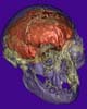 St Louis MO (SPX) Mar 07, 2005
A fossil of a diminutive human nicknamed "the Hobbit" likely represents a previously unrecognized species of early humans, according to the results of a detailed comparison of the fossil's brain case with those of humans, apes and other human ancestors.
|
| ||||||||||
| The content herein, unless otherwise known to be public domain, are Copyright 1995-2016 - Space Media Network. All websites are published in Australia and are solely subject to Australian law and governed by Fair Use principals for news reporting and research purposes. AFP, UPI and IANS news wire stories are copyright Agence France-Presse, United Press International and Indo-Asia News Service. ESA news reports are copyright European Space Agency. All NASA sourced material is public domain. Additional copyrights may apply in whole or part to other bona fide parties. Advertising does not imply endorsement, agreement or approval of any opinions, statements or information provided by Space Media Network on any Web page published or hosted by Space Media Network. Privacy Statement All images and articles appearing on Space Media Network have been edited or digitally altered in some way. Any requests to remove copyright material will be acted upon in a timely and appropriate manner. Any attempt to extort money from Space Media Network will be ignored and reported to Australian Law Enforcement Agencies as a potential case of financial fraud involving the use of a telephonic carriage device or postal service. |
