| . |  |
. |
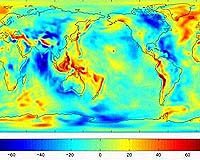
The joint NASA-German Aerospace Center Gravity Recovery and Climate Experiment (Grace) mission has released its first science product, the most accurate map yet of Earth's gravity field. Grace is the newest tool for scientists working to unlock secrets of ocean circulation and its effects on climate. Created from 111 days of selected Grace data, to help calibrate and validate the mission's instruments, this preliminary model improves knowledge of the gravity field so much it is being released to oceanographers now, months in advance of the scheduled start of routine Grace science operations. The data are expected to significantly improve our ability to understand ocean circulation, which strongly influences weather and climate. Dr. Byron Tapley, Grace principal investigator at UT's Center for Space Research, called the new model a feast for oceanographers. "This initial model represents a major advancement in our knowledge of Earth's gravity field. "Pre- Grace models contained such large errors many important features were obscured. Grace brings the true state of the oceans into much sharper focus, so we can better see ocean phenomena that have a strong impact on atmospheric weather patterns, fisheries and global climate change." Grace is accomplishing that goal by providing a more precise definition of Earth's geoid, an imaginary surface defined only by Earth's gravity field, upon which Earth's ocean surfaces would lie if not disturbed by other forces such as ocean currents, winds and tides. The geoid height varies around the world by up to 200 meters (650 feet). "I like to think of the geoid as science's equivalent of a carpenter's level, it tells us where horizontal is," Tapley said. "Grace will tell us the geoid with centimeter-level precision." So why is knowing the geoid height so important? JPL's Dr. Lee-Lueng Fu, scientist on Topex/Poseidon and Jason project said, "The ocean's surface, while appearing flat, is actually covered with hills and valleys caused by currents, winds and tides, and also by variations in Earth's gravity field. "Scientists want to separate out these gravitational effects, so they can improve the accuracy of satellite altimeters like Jason and Topex/Poseidon, which measure sea surface height, ocean heat storage and global ocean circulation. This will give us a better understanding of ocean circulation and how it affects climate." Dr. Michael Watkins, Grace project scientist at JPL, put improvements to Earth's gravity model into perspective. "Scientists have studied Earth's gravity for more than 30 years, using both satellite and ground measurements that were of uneven quality. "Using just a few months of our globally uniform quality Grace data, we've already improved the accuracy of Earth's gravity model by a factor of between 10 and nearly 100, depending on the size of the gravity feature. In some locations, errors in geoid height based upon previous data were as much as 1 meter (3.3 feet). Now, we can reduce these errors to a centimeter (0.4 inches) in some instances. That's progress." Dr. Christoph Reigber, Grace co-principal investigator at GeoForschungsZentrum Potsdam, said, "As we continue to assess and refine Grace's instruments and subsystems, we're confident future monthly gravity solutions will be even better than the map we're releasing now. "Those solutions will allow us to investigate processes associated with slow redistribution of mass inside Earth and on its land, ocean and ice surfaces. Our initial attempts to identify such small gravity signals with Grace look very promising." Grace senses minute variations in gravitational pull from local changes in Earth's mass by precisely measuring, to a tenth of the width of a human hair, changes in the separation of two identical spacecraft following the same orbit approximately 220 kilometers (137 miles) apart. Grace will map the variations from month to month, following changes imposed by the seasons, weather patterns and short-term climate change. Grace is a joint partnership between NASA and the German Aerospace Center. The UT Center for Space Research has overall mission responsibility. GeoForschungsZentrum Potsdam is responsible for German mission elements. Science data processing, distribution, archiving and product verification are managed under a cooperative arrangement between JPL, UT, and GeoForschungsZentrum Potsdam. Related Links Grace at University of Texas Grace at Potsdam SpaceDaily Search SpaceDaily Subscribe To SpaceDaily Express 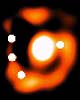 Paris - Jul 18, 2003
Using the ESO 3.6-m telescope at La Silla (Chile), an international team of astronomers [1] has discovered a complex cosmic mirage in the southern constellation Crater (The Cup). This "gravitational lens" system consists of (at least) four images of the same quasar as well as a ring-shaped image of the galaxy in which the quasar reside - known as an "Einstein ring". The more nearby lensing galaxy that causes this intriguing optical illusion is also well visible.
|
| ||||||||||
| The content herein, unless otherwise known to be public domain, are Copyright 1995-2016 - Space Media Network. All websites are published in Australia and are solely subject to Australian law and governed by Fair Use principals for news reporting and research purposes. AFP, UPI and IANS news wire stories are copyright Agence France-Presse, United Press International and Indo-Asia News Service. ESA news reports are copyright European Space Agency. All NASA sourced material is public domain. Additional copyrights may apply in whole or part to other bona fide parties. Advertising does not imply endorsement, agreement or approval of any opinions, statements or information provided by Space Media Network on any Web page published or hosted by Space Media Network. Privacy Statement All images and articles appearing on Space Media Network have been edited or digitally altered in some way. Any requests to remove copyright material will be acted upon in a timely and appropriate manner. Any attempt to extort money from Space Media Network will be ignored and reported to Australian Law Enforcement Agencies as a potential case of financial fraud involving the use of a telephonic carriage device or postal service. |