| . |  |
. |
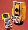 Sunnyvale - October 15, 1998 - Demonstrating its commitment to providing high-performance positioning systems to the land surveying industry, Trimble introduced today the TTS 500 -- an optical
extension to the GPS Total Station Family. The TTS 500 optical surveying
instrument with reflectorless technology is designed to work in areas where Global Positioning System (GPS) signals are weak or obstructed. Sunnyvale - October 15, 1998 - Demonstrating its commitment to providing high-performance positioning systems to the land surveying industry, Trimble introduced today the TTS 500 -- an optical
extension to the GPS Total Station Family. The TTS 500 optical surveying
instrument with reflectorless technology is designed to work in areas where Global Positioning System (GPS) signals are weak or obstructed.Using the TTS 500, surveyors can collect data for topographic maps, stake-out construction sites, perform boundary, seismic and geodetic control surveys as well as photogrammetric work. In addition, Trimble also introduced the Survey Controller field software 7.0 for the TSC1 data collector and Trimble Survey Office software 1.5. These two new software versions provide an open architecture that allows seamless data flow and flexibility between Trimble's GPS Total Station(R) 4700, 4800 and the new TTS 500, as well as with other manufacturer's optical stations and laser rangefinders. This interoperability between GPS and optical instruments optimizes productivity by giving the surveyor a compatible set of tools to tackle any surveying situation. "Trimble is committed to the surveying industry and the TTS 500 is our first step in providing positioning systems that address the surveyor's needs in areas where GPS is not the optimal solution," said Joseph Paiva, Trimble's vice president of land survey. "As part of the Total Station Family, the TTS 500 adds a new dimension of flexibility and versatility to our product line." TTS 500 - Optical Surveying Instrument The TTS 500 is an optical surveying instrument with reflectorless EDM technology that capitalizes on the benefits offered in Trimble's GPS data collection systems. Its unique mechanical design and reflectorless technology allows a single surveyor to speed through measurements that would require significantly more time with conventional optical instruments. The TTS 500 EDM provides millimeter accuracy for surveying areas where GPS signals are obstructed such as tunnels, parking garages and dense forests, as well as building facades or dam faces that are difficult or dangerous to reach. Survey Controller 7.0 Software - Full Interoperability in the Field Trimble's Survey Controller 7.0 software runs on the revolutionary handheld TSC1 data collector. The TSC1 is an extremely rugged, yet easy-to-use, handheld unit for system control and data logging. The software's task-oriented controls take surveyors through every operation efficiently for total control of GPS equipment and conventional surveying instruments, including laser rangefinders and optical stations made by other manufacturers. This new, integrated software version handles everything from processing GPS, optical and Real-Time Kinematic (RTK) data, to the translation and export of the information to survey, CAD design software. Fully interoperable with GPS and conventional instruments from leading manufacturers, the TSC1 with Survey Controller software is the ideal choice today for surveyors. Trimble Survey Office 1.5 Software - Optimizes Productivity Trimble Survey Office 1.5 software is an integral part of Trimble's GPS and conventional surveying system interoperability. It is the first software to allow processing of raw GPS measurements, real-time GPS measurements and data from popular optical survey instruments in a single package. The software is compatible with both Windows(R) 95 and Windows NT 4.0. Users can take advantage of several new features that enhance data flow between the field and the office. Automatic reduction of field data and map generation allow the user to quickly download field data and produce accurate designs for roading, construction and engineering. When the surveyor is ready to return to the field to stakeout points, the Trimble Survey Office translates the design information and transfers a complete project file to the Survey Controller. The controller then navigates the surveyor to each point and instantly calculates a cut or fill. If conditions require optical measurements the surveyor can connect the controller to the TTS 500 or any other conventional total stations to finish the job. Availability The TTS 500 is anticipated to be available in January 1999 through Trimble's authorized Survey and Mapping distributors worldwide. The TSC1 with Survey Controller 7.0 and Trimble Survey Office 1.5 are anticipated to be available November 1998.
|
| |||||||||
| The content herein, unless otherwise known to be public domain, are Copyright 1995-2016 - Space Media Network. All websites are published in Australia and are solely subject to Australian law and governed by Fair Use principals for news reporting and research purposes. AFP, UPI and IANS news wire stories are copyright Agence France-Presse, United Press International and Indo-Asia News Service. ESA news reports are copyright European Space Agency. All NASA sourced material is public domain. Additional copyrights may apply in whole or part to other bona fide parties. Advertising does not imply endorsement, agreement or approval of any opinions, statements or information provided by Space Media Network on any Web page published or hosted by Space Media Network. Privacy Statement All images and articles appearing on Space Media Network have been edited or digitally altered in some way. Any requests to remove copyright material will be acted upon in a timely and appropriate manner. Any attempt to extort money from Space Media Network will be ignored and reported to Australian Law Enforcement Agencies as a potential case of financial fraud involving the use of a telephonic carriage device or postal service. |