| . |  |
. |
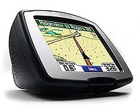
Garmin International has introduced the StreetPilot c320 and c330, a new series of automotive GPS navigators that combine an intuitive, easy-to-use operating system with an elegant and refined design - at a very affordable price. The StreetPilot c320 and c330 were unveiled at the 2005 International Consumer Electronics Show (CES) in Las Vegas, and are currently on display at the company's booth (#31250). "Garmin designed the new StreetPilot c-series from the ground up as a simple yet powerful automotive GPS navigation device - perfect for commuters, cross-country travelers, or anyone else on the go," said Gary Kelley, Garmin's director of marketing. Garmin's new StreetPilot c-series features an intuitive touchscreen interface - designed to make GPS navigation easy for everyone. Selecting a destination is straightforward and requires only a limited amount of input from the user. The c-series provides premium in-car navigation capability with automatic route calculation to any destination and turn-by-turn voice- prompted directions along the way. The c-series offers all of the functions of a premium in-dash system at a fraction of the cost. The StreetPilot c-series also allows users to choose between a three- dimensional navigation view, or the more traditional "bird's eye" overhead view. The new 3D navigation perspective lets drivers see an uncluttered view of what's down the road, and gives visual and voice-prompted turn-by-turn information directly on the unit's map page. For the ultimate out-of-the-box convenience, the StreetPilot c330 comes pre-loaded with highly detailed MapSource City Select street data of the entire United States, Canada, and Puerto Rico. The database features an industry-leading five million-plus points of interest - including hotels, restaurants, gas stations, ATMs, and attractions. Map data is provided by NAVTEQ - a world leader in premium-quality mapping. For budget-conscious users who only require detailed maps for a limited area, the StreetPilot c320 features an SD card slot, a 128MB SD card, and MapSource City Select street data on CD-ROM. The user simply selects the specific area of interest and the data is transferred from a PC via a fast USB connection. For European drivers, the StreetPilot c320 map data is supplied by region onto a pre-programmed SD card. The centerpiece of both units is a bright, 3.5-inch diagonal, 16-bit color display with touchscreen that makes navigation a snap. The StreetPilot c320 and c330 feature dual integrated speakers for high-quality voice prompts, and an internal lithium-ion battery for out-of-car route planning. The new StreetPilot c-series boasts distinctive and sleek styling - the units' only buttons are a rotary volume knob and an on/off switch. The device is secured by a suction-mount cradle that fastens to the windshield, for easy portability between vehicles. Users can customize their unit's appearance with an array of colored faceplates (sold separately). The new StreetPilot c320 and c330 join Garmin's comprehensive line of automotive GPS navigators - from the full-featured StreetPilot 2600 series to the compact and versatile Quest. With its intuitive operating system, the new StreetPilot c-series is designed to attract new customers to the Garmin line - those who haven't yet experienced the ease, convenience, and peace-of- mind that comes with automotive GPS navigation. The StreetPilot c320 and c330 are expected to be available in March 2005 at an MSRP of $749.99 and $964.27, respectively. Both units are sold with a suction cup mount and 12-volt adapter, USB cable, AC charging cable, owner's manual, and setup guide. The StreetPilot c320 also includes a 128MB SD card and fully unlocked MapSource City Select CD-ROM. European versions of the StreetPilot c320 are sold with a pre-programmed regional SD card.
Garmin Builds A Bluetooth GPS Sensor For Mobile Devices Garmin International also introduced Wednesday the GPS 10, a sensor that receives location data from the Global Positioning System (GPS) and transmits that information to mobile devices enabled with Bluetooth wireless technology. The product made its debut at the 2005 International Consumer Electronics Show and will be displayed at the company's booth (#31250). The GPS 10 is compact (WxHxD: 1.8" x 3.5" x 0.8") and lightweight (2.8 oz.). It integrates a 12-parallel channel, WAAS-enabled GPS receiver and a Bluetooth transceiver to provide location data to a variety of mobile devices. The GPS 10 has a magnetic base and is waterproof, so it can be mounted inside or outside a vehicle. The sensor has an internal lithium-ion battery and the Deluxe package includes a 12-volt adapter, allowing the GPS 10 to run on its own power for up to 10 hours or on the vehicle's power. "We are excited to offer consumers a cost-effective GPS sensor, mapping and navigation package that will turn a Bluetooth-enabled PDA or mobile PC into a premium automotive navigation device," said Gary Kelley, Garmin's director of marketing. "The GPS 10 Deluxe package includes our exclusive MapSource City Select mapping data and two intuitive applications to deliver turn-by-turn navigation on a host of mobile devices with Bluetooth connectivity." Initially, the GPS 10 will communicate with Windows Mobile-based Pocket PCs, as well as laptops and tablet PCs that run on the Windows OS. The GPS 10 Deluxe package includes MapSource City Select North America mapping software, which offers more than 5 million points of interest and detailed street-level mapping of the entire U.S. and metropolitan Canada. It is also bundled with two easy-to-use applications for mobile navigation, depending on the device. First, Garmin provides its Que navigation application for handheld devices. This application delivers location awareness, address and points-of- interest lookup features, electronic mapping, automatic route generation, configurable road/area avoidance, off-route recalculation, and turn-by-turn directions with voice prompts. Another key capability within the Que application is the ability to navigate to an address stored within the Contacts database. Second, Garmin's nRoute application is provided for mobile PC users. This application displays City Select map data along with advanced find, routing and voice guidance functions for seamless navigation. Joining the GPS 18 in Garmin's family of GPS modules for mobile devices, the GPS 10 Deluxe with Bluetooth technology is expected to be available in January 2005 for $267.85 (MSRP). Related Links Garmin SpaceDaily Search SpaceDaily Subscribe To SpaceDaily Express Satelinx International has signed a 5 year contract with Auto Spa of Montreal, Canada, a contract representing sales for Satelinx of $1,380,000 USD over 5 years.
|
| ||||||||||
| The content herein, unless otherwise known to be public domain, are Copyright 1995-2016 - Space Media Network. All websites are published in Australia and are solely subject to Australian law and governed by Fair Use principals for news reporting and research purposes. AFP, UPI and IANS news wire stories are copyright Agence France-Presse, United Press International and Indo-Asia News Service. ESA news reports are copyright European Space Agency. All NASA sourced material is public domain. Additional copyrights may apply in whole or part to other bona fide parties. Advertising does not imply endorsement, agreement or approval of any opinions, statements or information provided by Space Media Network on any Web page published or hosted by Space Media Network. Privacy Statement All images and articles appearing on Space Media Network have been edited or digitally altered in some way. Any requests to remove copyright material will be acted upon in a timely and appropriate manner. Any attempt to extort money from Space Media Network will be ignored and reported to Australian Law Enforcement Agencies as a potential case of financial fraud involving the use of a telephonic carriage device or postal service. |