| . |  |
. |
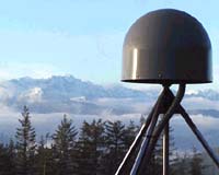
University of Nevada, Reno researchers have for the first time recorded a cluster of nearly 1,600 small earthquakes 20 miles beneath Lake Tahoe - the world's second-largest alpine lake. Based on observations from the university's Nevada Seismic Network and an ultra-sensitive Global Positioning System (GPS) station at Slide Mountain, the researchers believe the quake cluster coincided with an unprecedented 8-millimeter uplifting of the ski resort mountain in the Sierra Nevada. "We've been watching earthquakes for 30 years in the Tahoe area and have never witnessed an earthquake 'swarm' anything like this," said Ken Smith, research seismologist at the university's Nevada Seismological Laboratory and principal author of an article to be published in August in the journal, Science, and on its Science Express Web site on Aug. 5. The deep earthquake activity occurred from Aug. 12, 2003 through Feb. 19, 2004 and then stopped. "We haven't seen any more deep earthquakes or notable movement at the Slide Mountain GPS station since," Smith said. Geoff Blewitt, a research geophysicist with the university's Nevada Bureau of Mines and Geology and co-author of the Science article, added that the centimeter uplift at Slide Mountain "can be explained by the movement of magma about 20 miles deep, which forced several miles of rock apart by about 1 meter." He added that he and his colleagues believe the rapid growth of this fissure caused the series of earthquakes ? no greater than magnitude 2.2 ? that caused the mountain to rise. The university's Nevada Seismological Laboratory operates some 40 real-time seismograph stations in Nevada and eastern California near Lake Tahoe and more than 200 stations throughout the region. Its modern digital seismic instruments can sense the tiniest earthquakes even at depths of 20 miles below the surface. This network is supported by the U. S. Geological Survey as part of the National Earthquake Hazard Reduction Program, the U. S. Department of Energy, and by the State of Nevada. The university's network is part of the Advanced National Seismic System. The GPS stations are supported by the National Science Foundation and the U. S. Department of Energy. The eastern side of the Sierra Nevada is the West's third most seismically active area behind only Alaska and the San Andreas fault system in California. A number of active faults, capable of earthquakes as large as magnitude 7, have been identified in the Lake Tahoe basin. In fact, university researchers noted that over the past several million years, Lake Tahoe itself has been created by repeated earthquakes on the West Tahoe Fault, which runs along the lake's bottom and western side. The eastern front of the Sierra Nevada represents one of the fundamental tectonic boundaries in the United States. The mountain range moves at a rate of about 12 to14 millimeters per year to the northwest. Researchers believe the deep event observed at Lake Tahoe is part of the process of the evolution and westward growth of the Basin and Range Province. Co-authors of the article, "Moving Mountains and Lower Crustal Earthquakes at Lake Tahoe, California: Evidence for 30 km Deep Magma Injection" are Kenneth Smith, David von Seggern, Geoffrey Blewitt, Leiph Preston, John Anderson (all at University of Nevada, Reno), Brian Wernicke (California Institute of Technology); and James Davis (Harvard Smithsonian Center for Astrophysics). The University of Nevada, Reno has one of the world's most respected seismology research and earthquake engineering teams. Its Nevada Seismological Laboratory has overall responsibility for instrumental studies of earthquakes throughout the Silver State. This laboratory serves as a repository of information and a resource for the public on earthquake activity, risks and safety measures in Nevada and adjoining states. The university's Nevada Seismic Network's 200 stations locate over 7,000 earthquakes per year. Reno and Las Vegas are among the 30 urban centers in the nation with the highest estimated annualized earthquake loss, according to the Federal Emergency Management Agency. The Geodesy Group at the university's Nevada Bureau of Mines and Geology operates a 36-station GPS network spanning the Central Nevada Seismic Belt and the northern Walker Lane, capable of monitoring sub-millimeter motions of the Earth's surface, which continuously deforms as stress builds up between earthquakes. The Geodesy Group is also using the same GPS technology to monitor both the geological stability of the Yucca Mountain region and land subsidence due to ground water extraction in Las Vegas Valley. The group made the recent discovery that global redistribution of surface water is the leading cause for the "wobble" of Earth's pole of rotation. In addition, the university's Center for Civil Engineering Earthquake Research boasts one of the United States' top earthquake simulation laboratories. The $30 million laboratory includes the nation's only set of three 50-ton "shake" tables that are able to simulate large earthquakes. The university is a member of the National Science Foundation's Network for Earthquake Engineering Simulation, an exclusive group of only 15 universities involved in carrying out research and obtaining information vital for reducing the nation's vulnerability to catastrophic earthquakes. Related Links University of Nevada SpaceDaily Search SpaceDaily Subscribe To SpaceDaily Express  Seattle WA (SPX) Aug 05, 2004
Mayor Greg Nickels today officially launched the Puget Reference Station Network (PRSN), a regional Global Positioning System (GPS) network, which covers 1,600 square miles and will provide significant benefits for Seattle and the surrounding regions.
|
| ||||||||||
| The content herein, unless otherwise known to be public domain, are Copyright 1995-2016 - Space Media Network. All websites are published in Australia and are solely subject to Australian law and governed by Fair Use principals for news reporting and research purposes. AFP, UPI and IANS news wire stories are copyright Agence France-Presse, United Press International and Indo-Asia News Service. ESA news reports are copyright European Space Agency. All NASA sourced material is public domain. Additional copyrights may apply in whole or part to other bona fide parties. Advertising does not imply endorsement, agreement or approval of any opinions, statements or information provided by Space Media Network on any Web page published or hosted by Space Media Network. Privacy Statement All images and articles appearing on Space Media Network have been edited or digitally altered in some way. Any requests to remove copyright material will be acted upon in a timely and appropriate manner. Any attempt to extort money from Space Media Network will be ignored and reported to Australian Law Enforcement Agencies as a potential case of financial fraud involving the use of a telephonic carriage device or postal service. |