| . |  |
. |
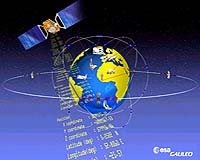
Beijing - Sep 27, 2003 September 19 saw the inauguration of the "China-Europe Global Navigation Satellite System Technical Training and Cooperation Center" for the Galileo project, an independent European satellite constellation that will rival the US military's domination of the Global Positioning System (GPS). September 19 saw the inauguration of the "China-Europe Global Navigation Satellite System Technical Training and Cooperation Center" (CENC) in Beijing to train staff and organize bilateral exchange for the Galileo project, an independent European satellite constellation that will rival the US military's domination of the Global Positioning System (GPS). This marks the beginning of China-Europe cooperation in the project, and the news was immediately relayed by foreign media and drew world attention. Only Americans know precisely the position of any object on the earth, other countries only know "roughly" What is the Galileo project? Let's start from the Global Positioning System (GPS)? People generally use surrounding objects as reference to define a position. For example, we describe the position of the Tiananmen Square as one "on the north side of Chang'an Avenue, the east side of Zhongshan Park, and the west side of the Working People's Cultural Palace". However, it is impossible to find objects of reference in a vast ocean or uninhabited desert when defining the position of a ship or a vehicle. So people invented the conception of latitude and longitude to determine the horizontal position of any object on the earth. But how can a sailing ship, or a running car, know the latitude and longitude where itself is in? That makes it necessary to use the GPS. This is a space technology put into use by the US military in 1973, which was mainly composed of 24 satellites orbiting around the earth, sending out continuously radio signals of a certain frequency from a height about 17,000 kilometers above ground. These satellites can serve as objects of reference for any target on the earth, and a signal receiver could decide its position by only selecting signals from 4 satellites for analyses. From the 1991 Gulf War till now, all the US military operations would have been impossible without GPS--its receivers were equipped to every combating unit and even individuals. Using the GPS, a shot down pilot reported his actual position to get the fastest rescue, and ground-to-air missiles and cruise missiles, with the accurate guidance of GPS, can double or redouble their precise hitting powers. GPS can also be widely used in people's daily life, for instance, using it on ships, planes, automobiles and mobile telephones, thus creating huge economic benefits and social effect. GPS is therefore called another major achievement in space technology following humanity's landing on the moon and the invention of space aircraft. It is a system for both military and civilian use and opens to the globe free of charge. Anybody who buys a GPS locator can receive positioning signals. However, for a long time, what the United States has provided to its military units are precise positioning signals, whereas the ones it provided to other users are low-precision signals (with deliberately added interference). That is to say, only Americans know the exact position of any object on the earth, other countries only have a "general idea" concerning the position. The Galileo project brings a sense of pride to Europeans, it is by no means inferior to "Airbus" aircraft and "Ariane" rocket Let Americans guide their own warships and fighters? Russia is the first to show its worries. Russian Defense Ministry in 1995 launched 24 high and medium-degree circular-orbit satellites at a cost of over US$3 billion and set up its own global positioning system, which, called GLONASS for short, has a precision better than the GPS added with interference. After five years of repeated discussion and analysis, Europe set forth in 1999 the Galileo project. In March 2002, 15 communication ministers from EU members decided to kick off the project when they met in Brussels. The Galileo project, involving an investment estimated at 3.6 billion Euro, is made up of 30 satellites distributed in three orbits at a height of 24,000 kilometers. Unlike the United States and Russia, EU declared that Galileo is tailored for civilian use only, providing precise global positioning service with an error no more than 1 meter. Americans became restless, and tried to hold back the project by employing both hard and soft tactics. On the one hand, the United States stressed that there is no need for Europe to implement the Galileo project, and set barriers in frequency sharing. On the other hand, it canceled long-term interference with the GPS as of May 1, 2000, raising its positioning precision for civilian purposes from the 100-meter level to 10 meters. But these efforts didn't shake EU's determination to build a positioning system of its own. When starting the Galileo project, European Commission President Romano Prodi indicated that this program is a big event concerning Europe's future, a fight between monopoly and anti-monopoly, and a diplomatic combat involving politics, economy and military as well as national interests. The sense of pride it inspires in the European people is by no means inferior to that done by the "Airbus" aircraft and "Ariane" rocket. China's hundred million mobile users and rapid increase in the number of vehicles provide good market prospects for the Galileo program Why does EU cooperate with China in the Galileo program? Researcher Cao Chong, a deputy chief engineer with the 22nd research institute under the China Electronics Technology Group Corporation, said that there are two major factors for this. Firstly, China's support and participation can facilitate EU's negotiation with the United States and Russia on cooperation. Secondly, China's huge market provides promising prospects for the program. By now GPS technology has been fully applied to automobiles and even mobile phones, and China's hundred million mobile users and its rapidly growing number of autos can tremendously expand Galileo's market domain. China also showed high enthusiasm for the project. After negotiations China's Ministry of Science and Technology initialed on September 18 an agreement with EU's Directorate-General Energy and Transport for wide cooperation in the process of implementing the Galileo program in the fields of satellite launching and manufacturing, experiment on the environment of radio transmission, ground system and radio frequency, as well as the standards for receivers. China is sure to become a space power in the 21st century, able and necessary to have its own global positioning system Why is China actively participating in the Galileo program? According to Prof. Guo Jingjun with the Terrestrial Space Information Research Institute of Tsinghua University, except for military uses, the huge economic returns brought by GPS can never be neglected. Although the United States sends GPS signals free of charge, it has made exorbitant money from selling receiving equipment. She gave an example, saying that in 1986 a GPS locator of common precision cost US$50,000, and one with high precision US$100,000. Today, a locator of a cell-phone size costs no more than US$2,000, and a high-precision locator only US$30,000. How much profit American corporations have carried off is imaginable. The Galileo project will be completely in place by 2007 and put into business operation by 2008. China's participation from the very beginning has made it possible to avoid the passive situation of knowing nothing about the GPS in the initial period. Tsinghua University and European corporations have shown intention to jointly R&D a compatible Galileo receiver and the receiver of American and Russian systems, thereby greatly raising positioning reliability. Will participation in the Galileo project clash with the development of China's own navigation system? Cao Chong explained that although the Galileo project is the biggest sci-tech cooperation program between China and EU, China's participation is rather limited, equivalent to only one EU member and accounting for a meager share of the investment. Furthermore, a lion's share of the funds will come from Chinese enterprises taking part in the cooperation. China attaches great importance to its satellite navigation system. Last May, the nation sent into space its third "Beidou" (the Big Dipper-1) navigation positioning satellite, forming a complete positioning system together with the first two "Beidou" satellites launched in 2000, a system with the improved precision reaching dozens of meters and having communication functions. China's "Beidou" navigation system is a regional positioning system mainly covering the country and its neighboring areas, thus making vertical positioning impossible and limiting the number of users. Academician Liang Sili, who once served as the general engineer of the nation's Aerospace Ministry, said that the global positioning system is a apace infrastructure facility. China is bound to be a space power in the 21st century, able and necessary to possess its own navigation system. The Sino-EU cooperation will significantly help China to attain its goal. This article on page 5 of People's Daily, September 24, was written by PD reporter Ren Jianmin and translated by PD Online staff member Li Heng. It is reprinted here on SpaceDaily for research purposes only. Related Links Galileo at ESA Galileo at EU SpaceDaily Search SpaceDaily Subscribe To SpaceDaily Express  Paris - Sep 19, 2003
Europe and China share a common interest in cooperating to bring the benefits of satellite navigation and Galileo in particular to transport, science, land management, disaster prevention and other user sectors. Sharing research results, encouraging education, joint projects and industrial contacts are important means towards such goals.
|
| ||||||||||
| The content herein, unless otherwise known to be public domain, are Copyright 1995-2016 - Space Media Network. All websites are published in Australia and are solely subject to Australian law and governed by Fair Use principals for news reporting and research purposes. AFP, UPI and IANS news wire stories are copyright Agence France-Presse, United Press International and Indo-Asia News Service. ESA news reports are copyright European Space Agency. All NASA sourced material is public domain. Additional copyrights may apply in whole or part to other bona fide parties. Advertising does not imply endorsement, agreement or approval of any opinions, statements or information provided by Space Media Network on any Web page published or hosted by Space Media Network. Privacy Statement All images and articles appearing on Space Media Network have been edited or digitally altered in some way. Any requests to remove copyright material will be acted upon in a timely and appropriate manner. Any attempt to extort money from Space Media Network will be ignored and reported to Australian Law Enforcement Agencies as a potential case of financial fraud involving the use of a telephonic carriage device or postal service. |