| . |  |
. |
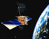
Boeing has been awarded one of two $16 million firm fixed price contract to study a new architecture for the GPS network. GPS III is a new initiative by the Air Force that will look at the next-generation GPS and how requirements for the satellite-based navigation system will evolve over the next 30 years. The GPS III architecture study will assess the mission needs and requirements of the existing system, and will validate their achievability by developing innovative architecture recommendations. Work is scheduled to begin immediately in Seal Beach, Calif. and will be managed out of Boeing Government Information & Communications Systems (GI&CS) headquarters in Anaheim, Calif. "This win provides Boeing with an exciting opportunity to continue its leadership role in helping the U.S. Air Force define the future of global navigation," said Carl O'Berry, GI&CS vice president and general manager. "I'm extremely pleased at the confidence of the Air Force in Boeing, as demonstrated by this important competitive win." Boeing, the world's premier satellite company and developer of navigation systems, has selected a team of industry leaders whose combination of unsurpassed GPS domain knowledge and broad understanding of military, commercial and civil navigation requirements will be vital in the development of a flexible solution to satisfy system users for the next 30 years. Team members include Boeing Satellite Systems, formerly Hughes Space and Communications Company, of El Segundo, Calif.; Computer Sciences Corporation (CSC) of Rockville, MD; Lockheed Martin Management and Data Systems (M&DS) of Gaithersburg, MD; and Raytheon Company of El Segundo, Calif. Boeing Satellite Systems will have responsibility for the space element. CSC, along with Boeing and Lockheed Martin M&DS will support the ground element. Raytheon Company will lead the user element with support from Boeing. The GPS III architecture study, the first of a three-phase program, will conclude in late 2001. Two contracts will then be awarded following open competition for the two-year program definition and risk reduction phase, which will lead to the selection in 2004 of one contractor who will develop and have total systems responsibility for the next-generation navigation system. For nearly three decades, Boeing has played a key role in what has become a vital worldwide utility. Boeing designed and developed 40 first- and second-generation Navstar GPS satellites and provided launch and on-orbit support from Shriever Air Force Base in Colorado. In April 1996, Boeing was selected by the Air Force to design, develop and produce the next-generation of GPS satellites, GPS IIF. GPS IIF is the product of more than 24 years of teamwork with the Air Force to shape a system architecture that ensures sustainment and flexibility to change. Up to 12 Block IIF spacecraft will be built through 2009. The GPS IIF program has recently definitized a $1 billion single prime initiative (SPI) contract for the ground control segment, which controls the Boeing IIF and the Lockheed-built IIR satellites. In addition, the U.S. Government has authorized the development of the GPS IIF modernization program, which includes the upgrade of six GPS IIF satellites and an additional buy of six modernized IIF satellites. "Boeing has built the foundation for a world-wide navigation system that has redefined the way we live our lives," said GPS III Program Manager Allen Lowry. "The Boeing GPS III team is committed to further developing and improving upon that legacy of success to help the Air Force create the vision for a new system that will satisfy military, commercial and civil users for years to come." Related Links SpaceDaily Search SpaceDaily Subscribe To SpaceDaily Express  Turin - Nov. 6, 2000
A Fiat car is putting a European satellite navigation system through its paces in Turin, Italy this week. EGNOS, which is being developed by a collaboration led by the European Space Agency, will be monitoring the car's position on a map with an accuracy of close to one metre.
|
| ||||||||||
| The content herein, unless otherwise known to be public domain, are Copyright 1995-2016 - Space Media Network. All websites are published in Australia and are solely subject to Australian law and governed by Fair Use principals for news reporting and research purposes. AFP, UPI and IANS news wire stories are copyright Agence France-Presse, United Press International and Indo-Asia News Service. ESA news reports are copyright European Space Agency. All NASA sourced material is public domain. Additional copyrights may apply in whole or part to other bona fide parties. Advertising does not imply endorsement, agreement or approval of any opinions, statements or information provided by Space Media Network on any Web page published or hosted by Space Media Network. Privacy Statement All images and articles appearing on Space Media Network have been edited or digitally altered in some way. Any requests to remove copyright material will be acted upon in a timely and appropriate manner. Any attempt to extort money from Space Media Network will be ignored and reported to Australian Law Enforcement Agencies as a potential case of financial fraud involving the use of a telephonic carriage device or postal service. |