| . |  |
. |
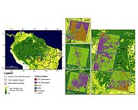
The Amazon, a vast tropical forest stretching across South America, is so large that is virtually impossible to study the evolving landscapes within the basin without the use of satellites. Scientists have used satellite imagery of the Amazon for more than 30 years to seek answers about this diverse ecosystem and the patterns and processes of land cover change. This technology continues to advance and a new study shows that NASA satellite images can allow scientists to more quickly and accurately assess deforestation in the Amazon. Location of Landsat test scenes and field validation area within the Brazilian Amazon. Percent tree cover values from the 2001 Vegetation Continuous Fields (VCF) product show the extent of forest cover in the region. Map subsets show 2002 Instituto Nacional de Pesquisas Espaciais (INPE) Prorgram for the Estimation of Deforestation in the Brazilian Amazon (PRODES) classifications for each test scene over 2001 VCF percent tree cover. Test scenes are presented in counter-clockwise order, beginning in the northeast with scene 223/66 and followed by 227/65 in the north, 232/67 in the west, and the cluster of scenes 226/67, 226/68, and 225/69 in central Mato Grosso state. Click image to enlarge. Credit: Doug Morton, University of Maryland-College Park Researchers from the University of Maryland-College Park, Brazil�s National Institute for Space Research (INPE) of Sao Jose dos Campos, Brazil, and South Dakota State University, Brookings, S.D., compared multiple years of data from NASA's Moderate Resolution Imaging Spectroradiometer (MODIS) aboard the Terra and Aqua satellites to data collected from the high-resolution Landsat satellite. They found that MODIS images can rapidly and reliably detect changes in Amazon land cover. Unlike MODIS data, analyses of high spatial resolution data demand extensive storage and processing requirements. And, in tropical forest regions, image quality is often reduced by cloud cover and infrequent coverage of high-resolution images. But MODIS obtains images of the Amazon up to four times per day and evaluations of the quality of data are provided with the image, clearly marking areas of clouds, water, or high aerosols. These impacts are further minimized with daily composites created through the combination of individual images. While high resolution imagery is still needed when estimating the total area of deforestation or when identifying small clearings, "the most exciting finding of this study is that it shows MODIS can permit regional analyses of land cover in a matter of days, a substantial reduction in effort in comparison to the months now required with Landsat," said Douglas Morton, scientist at the University of Maryland-College Park and lead author of the new study. Deforestation rates in tropical Africa, Southeast Asia, and South America have remained constant or have increased over the past two decades, altering global carbon emissions and climate while elevating the need for frequent and accurate assessment of forest loss. In the Brazilian Amazon alone, where the growth of cattle ranching and cropland agriculture are the primary causes of forest clearing, about 7,700 square miles of forest are clear-cut and burned each year, or roughly the area of New Jersey. This study found a marked trend of larger and more extensive deforestation events between 2001 and 2004 in Mato Grosso State, Brazil, which was later confirmed on the ground. Information like this is so valuable to scientists because the Amazon literally drives weather systems around the world. The tropics receive two-thirds of the world's rainfall, and when it rains, water changes from liquid to vapor and back again, storing and releasing heat energy in the process. With so much rainfall, an incredible amount of heat is released into the atmosphere - making the tropics the Earth's primary source of heat redistribution. And, because of the Amazon's location, any sort of weather hiccup from the area could signal serious changes for the rest of the world like droughts and severe storms. Global climate is also affected when Amazon burning practices to clear fields for farming result in large fires that create air pollution and release tiny particles, known as aerosols. Aerosols can both heat and cool the air, depending on size, shape and color. High concentrations of biomass burning aerosols also directly impact the local climate by increasing cloud formation but decreasing rainfall. In very smoky regions, cloud droplets form around the aerosol particles, but may never grow large enough to fall as rain. Building on the results of this study, Brazil's INPE has developed a near or almost real time monitoring application for deforestation detection known as the Real Time Deforestation Monitoring System (DETER) system. While this study highlights the challenges of monitoring deforestation and the use of MODIS data in the Amazon, it also shows that similar MODIS analyses could form the basis for a wide array of regional studies in a highly-automated fashion, with both scientific and decision-making utility. Related Links DETER SpaceDaily Search SpaceDaily Subscribe To SpaceDaily Express  Paris, France (ESA) Sep 14, 2005
Until now satellites have not been able to monitor melting of ice at the very point where it is most significant: at the ice edge. CryoSat's ability to do just that thrills scientists working in the field.
|
| ||||||||||
| The content herein, unless otherwise known to be public domain, are Copyright 1995-2016 - Space Media Network. All websites are published in Australia and are solely subject to Australian law and governed by Fair Use principals for news reporting and research purposes. AFP, UPI and IANS news wire stories are copyright Agence France-Presse, United Press International and Indo-Asia News Service. ESA news reports are copyright European Space Agency. All NASA sourced material is public domain. Additional copyrights may apply in whole or part to other bona fide parties. Advertising does not imply endorsement, agreement or approval of any opinions, statements or information provided by Space Media Network on any Web page published or hosted by Space Media Network. Privacy Statement All images and articles appearing on Space Media Network have been edited or digitally altered in some way. Any requests to remove copyright material will be acted upon in a timely and appropriate manner. Any attempt to extort money from Space Media Network will be ignored and reported to Australian Law Enforcement Agencies as a potential case of financial fraud involving the use of a telephonic carriage device or postal service. |