| . |  |
. |
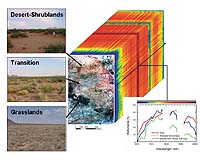
Using advanced remote-sensing techniques from a U-2 surveillance plane and field studies, scientists from the Carnegie Institution Department of Global Ecology have for the first time determined large-scale interactions between ecosystems and the climate during the process of desertification. The study, to be published in the January 2005 issue of Global Change Biology, is a milestone both for the new methods employed and for understanding what is happening as agricultural and grazing lands change into desert--a top environmental worry of the United Nations. "Grazing is the major form of land use on the planet, with the dry, semi-arid, and sub-humid regions supporting most of it throughout the world," explained Dr. Gregory Asner, lead author at Carnegie. "Some of these regions are turning into unusable desert so quickly that the United Nations has put the problem at the top of its environmental agenda. The challenge for science--to understand what is happening to ecosystems during desertification--has been enormous because the areas are so vast it is impossible to study the processes at the field level alone. "Our five-year project in the Northern Chihuahua region of New Mexico has successfully shown how the NASA Airborne Visible and Infrared Imaging Spectrometer (AVIRIS), aboard a NASA U-2, can be used to analyze the vegetation and soil changes in response to rain variation over large areas. I believe that the technique could become a standard for future global desertification studies." Typically, remote-sensing for ecological research looks at the greenness of the top layer of vegetation, which is used to determine the amount of plant growth, or net primary production (NPP). NPP data are useful for understanding the global carbon cycle as plants breath in and lock up the greenhouse gas CO2. NPP data, though, are not as important as are the changes in the type and distribution of vegetation as an area transitions into desert. Using the (AVIRIS), the scientists are able to analyze the physical structure of ecosystems including the live and dead plants. The data are viewed in 3-dimensions at very high resolution and can give a much broader picture of the processes at work, including carbon cycling and other chemical and biological activities. The entire study region was about 500 square miles (800 square kilometers). Each data pixel covered an area 62 feet by 62 feet (19 meters) and looked at the ecosystem-climate interactions of grasslands, transitional terrain, and desert-shrub landscape over a five-year period. The researchers made their measurements after wintertime and summer monsoonal rains, which varied in intensity by more than 300%. "We found that a long-term decrease in litter cover is the most evident sign when an area begins to change to desert." stated Asner. "More bare soil areas and changes in green vegetation are also apparent, but they are secondary. Up to now the scientific community has focused on bare soil much more than the loss of natural litter as dry areas become desert. "We also noted how the different vegetation types changed in response to the variation in rain. As areas exhibited more desert-like vegetation, there was a shift in plant responses from summer to winter precipitation events." he continued. Dr. Christopher Field, director of the Department of Global Ecology, commented on the research: "Desertification affects the future prospects for hundreds of millions of people. Like many of the most important environmental problems of our day, desertification involves complicated interactions among climate, vegetation, and human actions. "Unraveling those interactions will provide the keys to solving the problem. The techniques developed for this study open desertification and a wide range of other environmental problems to detailed analysis. I'm very excited about the potential for this work from the Department of Global Ecology to make a real difference in peoples' futures," he concluded. Related Links Department of Global Ecology Carnegie Institution SpaceDaily Search SpaceDaily Subscribe To SpaceDaily Express  Sydney, Australia (SPX) Dec 10, 2004
The Managing Director of AstroVision Australia, Mr Michael Hewins, announced today the signing of a marketing agreement between AstroVision Australia Limited and Astro Research Corporation of Japan to work together in a business development capacity to develop the Japanese, Korean, and Chinese markets.
|
| ||||||||||
| The content herein, unless otherwise known to be public domain, are Copyright 1995-2016 - Space Media Network. All websites are published in Australia and are solely subject to Australian law and governed by Fair Use principals for news reporting and research purposes. AFP, UPI and IANS news wire stories are copyright Agence France-Presse, United Press International and Indo-Asia News Service. ESA news reports are copyright European Space Agency. All NASA sourced material is public domain. Additional copyrights may apply in whole or part to other bona fide parties. Advertising does not imply endorsement, agreement or approval of any opinions, statements or information provided by Space Media Network on any Web page published or hosted by Space Media Network. Privacy Statement All images and articles appearing on Space Media Network have been edited or digitally altered in some way. Any requests to remove copyright material will be acted upon in a timely and appropriate manner. Any attempt to extort money from Space Media Network will be ignored and reported to Australian Law Enforcement Agencies as a potential case of financial fraud involving the use of a telephonic carriage device or postal service. |