| . |  |
. |
When Georgia Tech Research Institute engineers developed FalconView in the early 1990s, their goal was to make flight planning easier for pilots by moving mapping software off big Unix systems and onto desktop and laptop computers. Yet researchers never envisioned how pervasive FalconView would be - both in terms of its users and uses. The multimedia software displays aeronautical charts, satellite images and elevation maps along with overlay tools that, for example, mark no-fly zones and ground obstructions. Originally designed for the U.S. Air Force's F-16 (known as the Fighting Falcon), FalconView has been adopted by a wide variety of aircraft and spread throughout other branches of the U.S. military. Most recently, it was enhanced for the Army's use. An integral part of the military's Portable Flight Planning Software, FalconView counts more than 20,000 users today. The software has won several awards, and Microsoft chairman Bill Gates even devotes a chapter to it in his book, "Business @ the Speed of Thought." "Convenience and time savings have been two key reasons for FalconView's success," said Terry Hilderbrand, a division chief at the Georgia Tech Research Institute's (GTRI) Information Technology and Telecommunications Lab. In fact, one FalconView user estimated that the software sliced his mission planning from 4.5 hours to 20 minutes. Ease of use is another big benefit. Case in point: Hilderbrand loaded FalconView on his son's laptop computer two days before his son, a member of the Third Infantry Division at Fort Benning, was deployed to Iraq. "There was no time to give him training on the software," Hilderbrand says. "Yet he was able to figure out the program on his own and generate maps for leaders in his platoon and battalion in Iraq, which was important to rapid movement in the desert." FalconView's open architecture and interoperability also have contributed to its popularity, and several European nations use a special version of the software for their air forces. Through the years, GTRI researchers have continued to expand FalconView's capabilities and make it more robust, particularly in the area of situational awareness. By reading and parsing messages from tactical radios, FalconView creates a visual representation that shows users the position in near real-time of friendly and enemy forces. "That's critical in preventing fratricide, which was a problem in the first Gulf War," noted Dave Millard, a GTRI research engineer who works on FalconView. Researchers have also added illumination-planning features to FalconView, which enable Special Forces to plan flight paths that keep their aircraft in the shadows. "If you're flying a mission, you want to stay out of sight," said FalconView project director Chris Bailey. The software helps aviators determine the best place to fly, based on altitude, elevation of terrain and position of the sun or moon. Another recent component is SkyView, a tool that combines elevation data with maps and imagery to create a 3-D perspective. Aviators use SkyView primarily for mission rehearsal. FalconView is used for a wide range of mapping activities, including many non-combat objectives: Firefighting: The U.S. Forest Service has used FalconView to help drop fire retardant and communicate with ground workers about where and how fast forest fires are spreading. Whale sightings: FalconView has helped the U.S. Navy track whales for an environmental study. Drug traffic: U.S. Customs agents use FalconView to track drug-runners who fly small aircraft into the country. Forensics tool: Members of the military's history department have used the mapping software to help in missing-in-action cases by recreating geographic conditions on the days that aircraft have crashed. Components of FalconView are now being adapted to the new Joint Mission Planning System, the military's next-generation mission planner. "Although FalconView was originally designed for a very specific use, it's been successfully adapted to a wide range of applications," Hilderbrand said. "GTRI could do a lot of projects that bring in funding, but we like to do ones that will have a real impact. And FalconView certainly has - it's gone way beyond our expectations." Related Links SpaceDaily Search SpaceDaily Subscribe To SpaceDaily Express  Washington DC (SPX) Jul 20, 2004
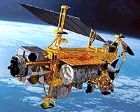
NASA will decommission the Tropical Rainfall Measuring Mission (TRMM) later this year. A highly successful scientific research mission, TRMM has provided data used worldwide in the monitoring and forecasting of hazardous weather on a demonstration basis.
|
| ||||||||||
| The content herein, unless otherwise known to be public domain, are Copyright 1995-2016 - Space Media Network. All websites are published in Australia and are solely subject to Australian law and governed by Fair Use principals for news reporting and research purposes. AFP, UPI and IANS news wire stories are copyright Agence France-Presse, United Press International and Indo-Asia News Service. ESA news reports are copyright European Space Agency. All NASA sourced material is public domain. Additional copyrights may apply in whole or part to other bona fide parties. Advertising does not imply endorsement, agreement or approval of any opinions, statements or information provided by Space Media Network on any Web page published or hosted by Space Media Network. Privacy Statement All images and articles appearing on Space Media Network have been edited or digitally altered in some way. Any requests to remove copyright material will be acted upon in a timely and appropriate manner. Any attempt to extort money from Space Media Network will be ignored and reported to Australian Law Enforcement Agencies as a potential case of financial fraud involving the use of a telephonic carriage device or postal service. |