| . |  |
. |
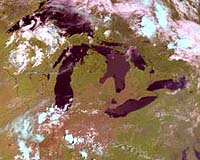
Ohio State University engineers are helping satellites form a clearer picture of water quality in the Great Lakes. The study - the first ever to rate the effectiveness of various computer models for monitoring the Great Lakes - might also aid studies of global climate change. As algae flourishes in the five freshwater lakes every summer, satellite images show the water changing color from blue to green, explained Carolyn Merry, professor of civil and environmental engineering and geodetic science. When algae levels are too high, water takes on a foul taste and odor that isn't easily removed by traditional treatment methods. Some forms of algae, such as one called microcystis, are toxic when consumed in large quantities. Though it can be filtered out of drinking water, microcystis can kill fish and birds, and coastal communities often have to ban swimming and water skiing in the summer when the algae blooms. Computer models enable scientists to measure the color of light reflected from the water to gauge how much algae is present in a lake, and where. The problem: all the available models of this type were originally designed for sea water, not lake water. "They've got it down pat for the ocean," Merry said of the various models developed by NASA and other agencies over the years. "But lakes are shallower and have different water conditions that affect the wavelengths of light collected by the satellites, so we can get erroneous measurements." Merry and master's degree student Raghavendra Mupparthy reported the results of an initial study of Lake Erie May 25 in Denver at the meeting of the American Society for Photogrammetry & Remote Sensing. They determined which four of the top ocean models may perform well for studies of the Great Lakes. Most scientists look for evidence of climate change in the oceans rather than in lakes, but that may change in the future, the engineers said. "Lakes are important because they respond much faster to climate change than oceans do," Mupparthy said. Erie is the warmest of the Great Lakes, the shallowest and richest in life, and has changed much in recent years. For instance, the lake has experienced a microcystis outbreak every summer since 1995. The warmer the temperature, the bigger the outbreak, Merry said. Though lakeside towns routinely measure algae levels firsthand, satellite images give scientists a broader view of trends in the lakes. "If we want to really understand whats happening in Lake Erie, we can take these computer models and marry them to other data to get a more complete picture," Merry said. The models could also apply to other large lakes and seas, such as the Mediterranean. The key to proving the models valid, she said, is to compare them to actual measurements of algae in the water. That's what she and Mupparthy did for Lake Erie, by collecting water samples from four sites in October 2000. They compared the actual algae levels to the levels suggested by 17 different models, each using images of the lake taken by NASA's SeaStar spacecraft. Model performance varied widely; one demonstrated an error of more than 250 percent, while several were off by less than one percent. What set the top-performing models apart was how well they enabled the engineers to remove the interference of atmospheric molecules. Over the ocean, carbon dioxide, ozone, and humidity are fairly constant, but amounts of these molecules fluctuate dramatically over lakes depending on the weather and human activity. The National Oceanic and Atmospheric Administrations Cooperative Institute for Limnology and Ecosystems Research funded this study. Merry and Mupparthy have applied for funding to collect water samples from more sites, with the hope of customizing a model for Lake Erie. Related Links SpaceDaily Search SpaceDaily Subscribe To SpaceDaily Express  Denver CO (SPX) May 25, 2004
DigitalGlobe reports that Denver's Wastewater Management Division (WMD) has evaluated QuickBird imagery and DigitalGlobe's impervious surface map products in order to streamline WMD's storm water billing operation.
|
| ||||||||||
| The content herein, unless otherwise known to be public domain, are Copyright 1995-2016 - Space Media Network. All websites are published in Australia and are solely subject to Australian law and governed by Fair Use principals for news reporting and research purposes. AFP, UPI and IANS news wire stories are copyright Agence France-Presse, United Press International and Indo-Asia News Service. ESA news reports are copyright European Space Agency. All NASA sourced material is public domain. Additional copyrights may apply in whole or part to other bona fide parties. Advertising does not imply endorsement, agreement or approval of any opinions, statements or information provided by Space Media Network on any Web page published or hosted by Space Media Network. Privacy Statement All images and articles appearing on Space Media Network have been edited or digitally altered in some way. Any requests to remove copyright material will be acted upon in a timely and appropriate manner. Any attempt to extort money from Space Media Network will be ignored and reported to Australian Law Enforcement Agencies as a potential case of financial fraud involving the use of a telephonic carriage device or postal service. |