| . |  |
. |
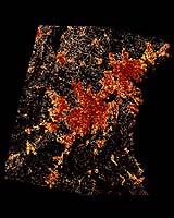
According to NASA-funded researchers, developed land in the greater Washington-Baltimore metropolitan area is projected to increase 80 percent by 2030. Scientists used a computer-based decision support model loaded with NASA and commercial satellite images to simulate three policies affecting land use. The researchers, Claire Jantz and Scott Goetz, from the University of Maryland, College Park, Md., and the Woods Hole Research Center, Woods Hole, Mass., also found a 39 percent increase in developed land in the region from 1986 to 2000. Some of the most striking changes occurred around the Dulles Airport area in Northern Virginia. Observations from NASA and commercial Earth observation satellites were used in a United States Geological Survey (USGS) computer model, called SLEUTH. The model was applied to 23,700 square kilometers (9151 sq. miles) of the Washington-Baltimore metropolitan area. The initial aim was to simulate the impact of future policy scenarios on the area and Chesapeake Bay watershed. "The satellite observations provided us with an unprecedented ability to monitor the urbanization process and capture the patterns of urban sprawl," Goetz said. The study is in the March issue of Environment and Planning B. It explains how models may be used to forecast the effects of urban growth and runoff on the Chesapeake Bay estuary system. The study showed how high resolution commercial imagery from Space Imaging's IKONOS satellite can be used to complement NASA's imagery from Landsat satellites. IKONOS images, with resolutions up to one meter (3.28 feet), were used with county-level air photos to link to 30-meter Landsat observations, which cover vast areas and offer a longer time frame for assessing urban change. The project was designed to study declining water quality in the Chesapeake Bay estuary due in part to disruptions in the hydrological system caused by urban and suburban development. The goal was to create a modeling system that could assess future development and support decision making by exploring the potential impact of different regional management scenarios. Future growth was projected out to 2030 using three different policy scenarios. The scenarios were based on current trends, managed, and ecologically sustainable growth. The current trends scenario simulated how the Washington metropolitan area might change if development policies remained the same. This scenario included forest and agricultural preservation already in place, leaving unprotected areas open for development. In this scenario, development increased by 80 percent by 2030. The managed growth scenario assumed added protection of forests and agriculture areas and placed moderate growth boundaries around already built areas. In this scenario, development increased by 30 percent by 2030. In the ecological scenario, strong protection of most forests and agricultural areas was projected, so development only increased by 20 percent by 2030. "The model is a tool that can be used for land use planning and resource management," Jantz said. "It offers the ability to explore and visualize alternative futures." The model is applicable to land use studies, and it has small to large-scale potential. It can also help decision-makers assess the configuration of landscapes in forests and urban areas, and understand sources of runoff related to water quality in streams. The Maryland Department of Natural Resources is exploring use of the model to target forest resources, restoration and conservation activities. Related Links SpaceDaily Search SpaceDaily Subscribe To SpaceDaily Express  Longmont CO - Mar 24, 2004
DigitalGlobe has unveiled details of the company's next-generation imaging satellite, WorldView. The new satellite, set to launch no later than 2006, will be the world's highest resolution commercial imaging satellite with better agility, accuracy and collection capacity than any other known commercial system.
|
| ||||||||||
| The content herein, unless otherwise known to be public domain, are Copyright 1995-2016 - Space Media Network. All websites are published in Australia and are solely subject to Australian law and governed by Fair Use principals for news reporting and research purposes. AFP, UPI and IANS news wire stories are copyright Agence France-Presse, United Press International and Indo-Asia News Service. ESA news reports are copyright European Space Agency. All NASA sourced material is public domain. Additional copyrights may apply in whole or part to other bona fide parties. Advertising does not imply endorsement, agreement or approval of any opinions, statements or information provided by Space Media Network on any Web page published or hosted by Space Media Network. Privacy Statement All images and articles appearing on Space Media Network have been edited or digitally altered in some way. Any requests to remove copyright material will be acted upon in a timely and appropriate manner. Any attempt to extort money from Space Media Network will be ignored and reported to Australian Law Enforcement Agencies as a potential case of financial fraud involving the use of a telephonic carriage device or postal service. |