| . |  |
. |
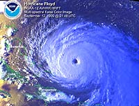
Every year, from June 1 to November 30, the Atlantic Ocean becomes a meteorological mixing bowl, replete with all the needed ingredients for a hurricane recipe. Forecasters who seek to monitor and understand hurricanes are increasingly turning to a cadre of NASA satellites and instruments, including several from NASA�s Jet Propulsion Laboratory, Pasadena, Calif., that serve up a feast of information on these awesome storms. Typically, during the peak of hurricane season, from late August to mid-September, tropical cyclones of interest to US coastal regions form around the Cape Verde Islands off Africa. NASA satellites are critical for helping forecasters determine if all of the ingredients are coming together to create a hurricane. If a hurricane forms, it is critical to know how strong it may be, and which coastal communities or sea lanes will be at risk. NASA provides researchers and forecasters with space-based observations, data assimilation and computer climate modeling. NASA-sponsored measurements and modeling of global sea surface temperature, precipitation, winds and sea surface height have also improved understanding of El Ni�o and La Ni�a events, which respectively tend to suppress and enhance Atlantic and Gulf hurricane development. Thirty years ago, meteorologists were unable to see the factors in hurricane formation and could only spot a hurricane with still pictures from the Television Infrared Operational Satellite - Next-generation (Tiros-N) spacecraft. Over the past 10 years, visible and infrared satellite sensors were the workhorses for monitoring hurricanes. Today, multiple NASA satellites exploit everything from radar pulses to microwaves for the purpose of enhancing forecasts, providing data to researchers several times a day. The first ingredient in the hurricane recipe is a sea surface temperature of at least 27.8 degrees Celsius (82 degrees Fahrenheit). Unlike traditional infrared satellite instruments, the Aqua satellite's Advanced Microwave Scanning Radiometer E and the Tropical Rainfall Measuring Mission's microwave imager can detect sea surface temperatures through clouds. This valuable information can help determine if a tropical cyclone is likely to strengthen or weaken. The joint U.S.-French Jason-1 satellite altimeter, managed by JPL, provides data on sea surface height, a key measurement of ocean energy available to encourage and sustain hurricanes. Another necessary ingredient is rotating winds over the ocean's surface, precursors to tropical cyclone development. The NASA-provided and JPL-built and managed SeaWinds instruments aboard Japan's Midori 2, and NASA's Quick Scatterometer (QuikScat) satellites can detect these winds before other instruments, providing even earlier notice of developing storms to forecasters and scientists. Air temperature and humidity are also important factors. The JPL-managed Atmospheric Infrared Sounder experiment suite aboard the Aqua satellite obtains measurements of global temperature and humidity throughout the atmosphere. This may lead to improved weather forecasts, improved determination of cyclone intensity, location and tracks, and the severe weather associated with storms, such as damaging winds. Rainfall intensity is the final ingredient, and the precipitation radar provided by Japan for the Tropical Rainfall Measuring Mission satellite provides computed tomography (CAT) scan-like views of rainfall in the massive thunderstorms of hurricanes. The mission�s instruments probe young tropical systems for rainfall intensity and the likelihood of storm development. The mission also sees "hot towers" or vertical columns of rapidly rising air that indicate very strong thunderstorms. These towers are like powerful pistons that convert energy from water vapor into a powerful wind- and rain-producing engine. Once a storm develops, the mission provides an inside view of how organized and tightly spiraled rain bands are, key indicators of storm intensity. The Tropical Rainfall Measuring Mission provides tropical cyclone intensity information from the safe distance of space, allowing the National Oceanic and Atmospheric Administration's National Hurricane Center and the Department of Defense Joint Typhoon Warning Center to turn to it, QuikScat and other NASA satellites for early assessment of storms in the open ocean. The hurricane monitoring capabilities enabled by these satellites are funded by NASA's Earth Science Enterprise, which is dedicated to understanding Earth as an integrated system and applying Earth system science to improve prediction of climate, weather and natural hazards using the unique vantage point of space. Related Links SpaceDaily Search SpaceDaily Subscribe To SpaceDaily Express  Pasadena - Aug 21, 2003
If a forest catches fire and no one is around to see it, can it call for help? The forest cannot call, but thanks to new technology developed by NASA, firefighters may get the word faster through new, high-tech eyes in the sky.
|
| ||||||||||
| The content herein, unless otherwise known to be public domain, are Copyright 1995-2016 - Space Media Network. All websites are published in Australia and are solely subject to Australian law and governed by Fair Use principals for news reporting and research purposes. AFP, UPI and IANS news wire stories are copyright Agence France-Presse, United Press International and Indo-Asia News Service. ESA news reports are copyright European Space Agency. All NASA sourced material is public domain. Additional copyrights may apply in whole or part to other bona fide parties. Advertising does not imply endorsement, agreement or approval of any opinions, statements or information provided by Space Media Network on any Web page published or hosted by Space Media Network. Privacy Statement All images and articles appearing on Space Media Network have been edited or digitally altered in some way. Any requests to remove copyright material will be acted upon in a timely and appropriate manner. Any attempt to extort money from Space Media Network will be ignored and reported to Australian Law Enforcement Agencies as a potential case of financial fraud involving the use of a telephonic carriage device or postal service. |