| . |  |
. |
"Just before launch we sit in the control room in the back row, completely quiet," says Palle S�rensen, "We have simulated everything, but when something went wrong we just rewound a little. Now that is no longer possible. We know it is for real and everything has to work." Palle S�rensen is Ground Segment Manager for the Envisat Mission and sees to it that receiving equipment on the ground -- computers, antennas, software, communication networks - and above all the control teams are operational. Up to 50 engineers and scientists sit at consoles in the control room with dozens of computer monitors and a huge screen with pictures, data, and graphics. Their job is to guide the environmental satellite from ESOC, the European Space Operations Centre in Darmstadt. The European Space Agency will launch Envisat early next year and operate it for the next 10 years. The Europe's newest, largest and most expensive satellite will orbit the earth 14 times a day and probe every corner of the earth for environmental pollution and climate change. It will measure and analyse greenhouse gases in the atmosphere, locate environmental polluters, identify ocean currents and algae growth, and keep a watch on the ozone hole. Its ten instruments are among the most sensitive created by modern sensor technology. They are capable of identifying and immediately reporting the smallest changes in natural and man-made processes on land, in water or air. From such information scientists can derive reliable models for climate change and even improve the forecasting of earthquakes, volcanic eruptions and flood tides. Such models demand a high degree of accuracy. When a satellite flies over the same position every few days, measurement errors can be calculated out. From an altitude of 800 kilometres Envisat will be able to see if the earth's surface has sunk a few millimetres -- as it has in Venice, which according to the latest satellite data is threatening to sink rather lopsidedly into the sea -- or risen as it does before a volcanic eruption. These kinds of observation demand the highest degree of precision in satellite orbits. "The location of Envisat is the most exact that we know," says S�rensen. His colleagues will work round the clock to train the satellite on the earth in precise paths "If we do not regulate the orbit correctly, we shall have huge problems. But that's why we have simulated every possible case." This is particularly true of one instrument: the second-generation synthetic aperture radar, or ASAR, which looks like a wide board on the belly of the satellite. It will transmit a weak radar signal to earth and receive its reflection from the surface. It will be able to calculate the height of glaciers, detect deforestation in the rain forest and pick out the smallest oil slick on the high seas. At a speed of almost 20,000 kilometres per hour this is no small feat. If the satellite were to lose its exact angle of vision, the reflection would ricochet into space. "There are different gravitational fields, a residual atmosphere, and there is the solar wind. All of which makes a big difference as to how often corrections are needed," says S�rensen, referring to automatic procedures on board; Envisat has about 50 different independent on-board computers. These recognise position automatically and operate gyroscopic instruments and magnets, with which the satellite maintains its exact orientation. "Position is survival", adds S�rensen. What happens if the eight tonne vehicle goes off course? "That's not the way to think about it," says S�rensen understandingly, "If it goes off course we see immediately on the instruments or know that the solar panel is not delivering enough current." S�rensen has worked on this mission for ten years. He has designed the infrastructure, procured the hardware, and tested software endlessly. After many test runs and countless simulations the fruits of this work are tangible. "It is not the first time we have done something like this," he announces proudly. In an emergency the engineers will have just 400 minutes. The satellite can circle the earth four times without power from the sun. "After that it's over, the satellite would be lost," broods S�rensen, but adds immediately: "we have thought through all procedures, there are rules and exact scenarios for everything and we have done multiple simulations for every contingency." Deployment of the solar panel shortly after launch has been practiced hundreds of times. All possible emergencies and errors are stored in the computer systems and can be called up at all times. The Darmstadt engineers intervene regularly and according to plan when a correction in the orbit becomes necessary. Every ten days, according to the ground manager's estimate, the orbit will have to be adjusted. "We have a lot of experience with this", says S�rensen, mentioning the successful manoeuvre to raise the orbit of the telecommunication satellite Artemis. The Envisat team was especially happy about that because, without Artemis, data traffic from Envisat would be problematic. Envisat will gather so much data that even the two 160 gigabyte hard disks would overflow after a few hours. It will therefore transmit its load of data every time it orbits the earth, when it races over the ESA ground station at Kiruna in northern Sweden. There will be just ten minutes to empty the on-board storage because after that Envisat has already disappeared over the horizon. If Kiruna is out of commission a second station at Svalbard in Norway is available. As an alternative to the giant receiving dishes on the ground Artemis, the telecommunications satellite parked high above the earth, will serve as a transmission station. Because Artemis is at an altitude 45 times higher than Envisat, every orbit gives it almost three quarters of an hour's "eye contact" with environmental satellites and it can very easily receive all data Envisat might want to unload. Afterwards Artemis sends the data to the ground station in its field of view. From there an incessant stream of data will flow directly to ESA's data processing centre, ESRIN, in Frascati, near Rome. In its lifetime ENVISAT will gather a petabyte of data. That is 1 followed by 15 zeros or a hard disk with the storage capacity of a million PCs. Software experts have developed hundreds of programs to make the valuable information available as effectively and quickly as possible. Preferential treatment of individual users is ruled out from the beginning. The ESRIN data is sent directly to six processing and archiving centres in England, Germany, Italy, France, Sweden and Spain. That guarantees equal information status for all participants and long-term security of archiving. These centres will supply thousands of scientists worldwide with raw data for climate research, catastrophe prevention, weather forecasting and environmental observation. Thanks to the fast channels of transmission data, like the analysis of the ozone measuring instrument GOMOS, will often be available in three hours. In order to meet the needs of all users, the experts in Frascati have developed four levels of quality for data security. Where extreme accuracy is required, it might be a month before ESRIN releases the data. That is how long Envisat needs to retrace the same orbit over the same place and confirm the accuracy of its measurements. The participating scientific institutes receive data at cost, approximately what it costs to copy, with the stipulation that it must be used for scientific purposes and published in its entirety. In this category are all researchers who have proposed an idea to a scientific committee and whose projects have been accepted. An impressive community of several thousand earth observers in Europe and worldwide has taken shape in the last few years. The ESRIN centre will serve as the data distribution coordinator for them. Envisat also has interesting economic potenaial. Analysts believe that environmental observation could one day become a branch of industry on the same scale as satellite navigation. This could well be since, as with GPS, the technology is likely to stimulate the imaginations of users. In order to sound out the market for data, two consortia are receiving select data from the Envisat Mission: EMMA under the leadership on the Italian company Eurimage and SARCOM under the direction of the French company SPOT. This could be interesting for ocean-going vessels. Envisat data could help them avoid especially stormy seas and high winds and steer clean of pack ice. Details of water with high plankton content will help freighters avoid filling their ballast in the wrong place and being sent back to sea by harbour authorities. The data from three instruments -- ASAR, MERIS and AATSR -- will be made available to everyone via the internet and on CD-Rom. Regional forecasts of very high UV radiation or warnings about carpets of poisonous algae at certain beaches can be factored in by everyone planning a holiday. And weekend sailors will soon be able to consult special maps to see where wind and surf are to be found. Ten turbulent years await the data managers in Frascati and the space helmsmen in Darmstadt. "We have to guide and manage everything," says S�rensen, but usually the job is "everyday work." he says contentedly. And then he lets slip: "Meanwhile we are already working on the next generation of environmental satellites -- and they will be a lot smaller." The relief in his voice is unmistakable. Related Links Envisat SpaceDaily Search SpaceDaily Subscribe To SpaceDaily Express  Paris - Nov 12, 2001
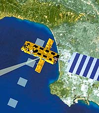
Early in 2002 an Ariane-5 rocket will launch the largest and most advanced Earth observation satellite ever built in Europe from the European Spaceport at Kourou in French Guiana. From an altitude of 800 kilometres Envisat will deliver images and data that will help us better understand and more effectively protect the Earth.
|
| ||||||||||
| The content herein, unless otherwise known to be public domain, are Copyright 1995-2016 - Space Media Network. All websites are published in Australia and are solely subject to Australian law and governed by Fair Use principals for news reporting and research purposes. AFP, UPI and IANS news wire stories are copyright Agence France-Presse, United Press International and Indo-Asia News Service. ESA news reports are copyright European Space Agency. All NASA sourced material is public domain. Additional copyrights may apply in whole or part to other bona fide parties. Advertising does not imply endorsement, agreement or approval of any opinions, statements or information provided by Space Media Network on any Web page published or hosted by Space Media Network. Privacy Statement All images and articles appearing on Space Media Network have been edited or digitally altered in some way. Any requests to remove copyright material will be acted upon in a timely and appropriate manner. Any attempt to extort money from Space Media Network will be ignored and reported to Australian Law Enforcement Agencies as a potential case of financial fraud involving the use of a telephonic carriage device or postal service. |