| . |  |
. |
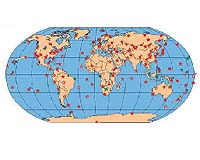
While nothing can undo the devastation from the massive tsunami that recently struck in Southeast Asia, lives can be saved in the future if scientists can rapidly characterize the earthquakes that cause tsunami. The quick response of the Global Seismographic Network to the 26 December 2004 Sumatra- Andaman earthquake offers clear opportunities to reduce the amount of time before an emergency response and assistance could be dispatched to a similarly afflicted area in the future. The 137-station network, funded by the U.S. National Science Foundation in partnership with the U.S. Geological Survey, is managed by the Incorporated Research Institutions for Seismology (IRIS) Consortium and operated by the USGS, the University of California, San Diego, and a number of domestic and international institutions to monitor earthquakes and other seismic activity worldwide. And, according to Jeffrey Park from Yale University and his colleagues, the recent subduction zone rupture that touched off the Asian tsunami was the first full-scale test of the system's technical design goals, set more than 20 years ago. The success of the network will become increasingly apparent as more highly detailed information from the global array is produced and studied, Park writes in an article about the seismographic network and the Sumatran earthquake for the 8 February issue of Eos, Transactions of the American Geophysical Union. The authors note that with the network now online, and with the planned addition of more seismograph locations into the system, strong seismic events in the future can be continuously monitored in unprecedented detail from the instant when the first signals arrive at monitoring stations. Such direct observations could allow scientists to quickly determine the magnitude of an event and its precise location in near real-time. Seismic waves from the 9.3-magnitude Sumatra earthquake, for example, reached a monitoring station in Sri Lanka within four minutes and caused the needles on thousands of seismometers worldwide to dance within 21 minutes, but earlier knowledge of the northwest direction of its rupture would have allowed for a more confident warning to the Indonesian coastline that bore the brunt of the tidal wave. The scientists point out, however, that a communications and public warning system was not yet established to spread the word about the resulting tsunami. "The terrible damage and loss of life wrought by this earthquake humbles the most dispassionate observer, as does the strong likelihood that one or more [similar] earthquakes will occur elsewhere in the coming century," Park writes in the article. "Technological advances have enabled real time data acquisition and rapid response capabilities that were not fully envisioned when the network was designed in 1984 and, while improved station coverage and telemetry would enhance the current system, its capabilities have not been exploited fully." The authors propose that a standardized, continuous system to track seismic signals could allow researchers to compile and interpret information about potential hazards sooner. Also, in an indication how the network could combine with an ocean-pressure tsunami monitoring system, the authors point out that later analyses of seismographic network data shows that it was possible to model at least a portion of the ground slip from the first three minutes of the Asian earthquake's seismic motion, which would have assisted in predicting the event and its subsequent aftershocks. The researchers predict that because of its unparalleled detail, data from the Global Seismographic Network is expected to drive new scientific discoveries in the future, ranging from a better understanding of the preliminary conditions prior to a fault rupture, to honing tsunami and flood models. The authors indicate that such studies, in combination with other geodetic information, could be applied to seismically active regions worldwide, like the Cascadia subduction zone in the Pacific Northwest. Related Links U.S. National Science Foundation U.S. Geological Survey Global Seismographic Network SpaceDaily Search SpaceDaily Subscribe To SpaceDaily Express  Bedminster NJ (SPX) Feb 04, 2005
Loral Skynet has announced that it has been selected to provide satellite communications services to the British Foreign and Commonwealth Office (FCO), through an agreement with Global Crossing, that will support the FCO's recovery efforts related to the tsunami disaster.
|
| ||||||||||
| The content herein, unless otherwise known to be public domain, are Copyright 1995-2016 - Space Media Network. All websites are published in Australia and are solely subject to Australian law and governed by Fair Use principals for news reporting and research purposes. AFP, UPI and IANS news wire stories are copyright Agence France-Presse, United Press International and Indo-Asia News Service. ESA news reports are copyright European Space Agency. All NASA sourced material is public domain. Additional copyrights may apply in whole or part to other bona fide parties. Advertising does not imply endorsement, agreement or approval of any opinions, statements or information provided by Space Media Network on any Web page published or hosted by Space Media Network. Privacy Statement All images and articles appearing on Space Media Network have been edited or digitally altered in some way. Any requests to remove copyright material will be acted upon in a timely and appropriate manner. Any attempt to extort money from Space Media Network will be ignored and reported to Australian Law Enforcement Agencies as a potential case of financial fraud involving the use of a telephonic carriage device or postal service. |