| . |  |
. |
An FAO-produced Atlas on areas affected by the 26 December 2004 tsunami in Southeast Asia has proven to be very useful to FAO teams and to Italian and other European officials and non governmental organizations working in the devastated zones. FAO has prepared the Tsunami Atlas using images collected from FAO databases and completed by major spatial data sources on the web. "These include raw satellite images, interpreted satellite images, topographic maps, thematic maps and geo-statistics," explained FAO remote sensing expert Dominique Lantieri.
Before and after "The Atlas shows the tsunami affected areas before and after the disaster, thus helping experts in evaluating the damage and estimating reconstruction and rehabilitation needs especially in the agricultural lands, the mangroves areas, as well in the coastal infrastructure that is used by farmers and fishermen," Mr. Lantieri added. The FAO Tsunami Atlas is well advanced for Indonesia and Sri Lanka which were hit hard by the waves. FAO is also working intensively regarding the other affected countries. Some of the satellite images showing areas affected by the tsunami have been interpreted by experts with the help of Geographic Information System (GIS) analysis. They show land features and details up to one meter of resolution in some cases.
Topographic maps Topographic maps which provide information on terrain, roads, villages have also been made available at 1:250000 scale, and a 1:50000 scale. In addition, the Atlas displays maps and statistics providing information on the local climate, the cropping calendars, levels of malnutrition, as well as the latest figures provided by aid workers on human losses and material damage, Mr. Lantieri said. The maps and images can be also used to incorporate field information collected by relief organizations, thanks to the GPS technology. So far, FAO has prepared and distributed a paper Atlas and a cd-rom version containing hundreds of tsunami related images and maps for Indonesia and Sri Lanka. The data is also available through Internet.
Wide distribution The Atlas will soon be distributed widely in hard copy throughout the tsunami affected countries, including national ministries, UN agencies and non-governmental organizations. Many of the images can be viewed and understood by non cartographic experts, and are made available in most common image computer format. An effort is underway to extend the Atlas to the other affected countries and to regularly update the maps and satellite images. It is expected that the Atlas will become a key reference cartographic document for operators working at the planning and field levels in the Tsunami affected areas. Related Links Food and Agriculture Organization of the United Nations SpaceDaily Search SpaceDaily Subscribe To SpaceDaily Express 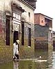 Beijing (XNA) Jan 24, 2005
An early warning system for weather disasters, a key part of China's meteorological strategic research programme, will be ambitiously upgraded this year.
|
| ||||||||||
| The content herein, unless otherwise known to be public domain, are Copyright 1995-2016 - Space Media Network. All websites are published in Australia and are solely subject to Australian law and governed by Fair Use principals for news reporting and research purposes. AFP, UPI and IANS news wire stories are copyright Agence France-Presse, United Press International and Indo-Asia News Service. ESA news reports are copyright European Space Agency. All NASA sourced material is public domain. Additional copyrights may apply in whole or part to other bona fide parties. Advertising does not imply endorsement, agreement or approval of any opinions, statements or information provided by Space Media Network on any Web page published or hosted by Space Media Network. Privacy Statement All images and articles appearing on Space Media Network have been edited or digitally altered in some way. Any requests to remove copyright material will be acted upon in a timely and appropriate manner. Any attempt to extort money from Space Media Network will be ignored and reported to Australian Law Enforcement Agencies as a potential case of financial fraud involving the use of a telephonic carriage device or postal service. |
