| . |  |
. |
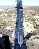
The NOAA-N spacecraft, a Polar Operational Environmental Satellite (POES), is being prepared for launch from Vandenberg Air Force Base, Calif. on May 11, 2005. Lockheed Martin Space Systems in Sunnyvale designed, built and tested the NOAA-N spacecraft. NOAA-N is the latest in the Advanced TIROS-N (ATN) satellite series. All have been designed and built for the National Aeronautics and Space Administration (NASA) by Lockheed Martin since the first Television and Infrared Observational Satellite (TIROS) weather satellite launch in April 1960. NASA is managing the spacecraft's launch and the National Oceanic and Atmospheric Administration (NOAA) will operate the satellite once in space. Over many years of service, the TIROS satellites have earned the reputation as the workhorses of the Civil Space Earth-imaging inventory. "Our long-standing partnership with our NASA customer is a genuine source of pride for Lockheed Martin, and we look forward to the launch of NOAA-N," said Dan Hoffman, Lockheed Martin TIROS program director. "The Lockheed Martin team has been totally dedicated to providing NASA with a series of satellites that extend NOAA's ability to provide uninterrupted environmental data products to users." A constellation consists of two POES satellites circling the planet in nearly north-south orbits. As the Earth rotates, the entire globe, one swath at a time rolls into view of the satellites' instruments. The satellites provide measurements of reflected solar and radiated thermal energy from land, sea, clouds and the atmosphere in the visible and infrared spectrum, atmospheric soundings of temperature and humidity, measurements of global sea surface temperature, aerosol distribution data, ozone concentration data, soil moisture data, and measurements of orbital proton and electron flux. Additionally, POES satellites collect data from remote platforms, relay search and rescue data, and also provide direct broadcast of environmental data worldwide. Data from the spacecraft supports a broad range of environmental monitoring applications including weather analysis and forecasting, climate research and prediction, ocean dynamics research, volcanic eruption monitoring and forest fire detection. Together these data comprise irreplaceable inputs to the numerical weather forecast model and are vital to medium and long-range forecasting. Separately or in combination, the data are utilized to produce sea-surface temperature maps, ice condition charts, vegetation maps and other forecasting and management tools. The NOAA-N spacecraft is 13.75 feet long by 6.2 feet in diameter, and weighs 3130 pounds at liftoff. Its solar array has 180.6 square feet of surface area and generates 833 watts at a zero degree sun angle. The instruments onboard NOAA-N were provided by NASA and NOAA, and include the Advanced Very High Resolution Radiometer (AVHRR/3), the High Resolution Infrared Radiation Sounder (HIRS/4), the Advanced Microwave Sounding Unit-A (AMSU-A1, A2), the Microwave Humidity Sounder (MHS), the Solar Backscatter Ultraviolet Radiometer (SBUV/2), the Space Environment Monitor (SEM/2) and the Data Collection System (DCS/2). In addition, NOAA-N carries two search and rescue instruments, the Search and Rescue Repeater (SARR) and the Search and Rescue Processor (SARP) that are used internationally for locating ships, aircraft, and people in distress. The use of satellites in search and rescue has been instrumental in saving more than 17,000 lives since the inception of the Search and Rescue Satellite-Aided Tracking (SARSAT) system. Spacecraft launch site processing at VAFB includes end-to-end testing with the Satellite Operations Control Center in Suitland, MD, final spacecraft electrical testing and spacecraft inspections. The NOAA-N spacecraft will be launched from the Western Range Space Launch Complex-2 at Vandenberg Air Force Base, by a two-stage Delta II 7320-10 space launch vehicle. Liftoff is slated to occur at 3:22 a.m. PDT. There will be a 10-minute window in which to launch. NASA's Goddard Space Flight Center, in Greenbelt, MD, is responsible for the procurement, development, launch services, and verification of the spacecraft, instruments, and unique ground equipment. Following spacecraft launch, Goddard is responsible for satellite health and safety during a comprehensive on-orbit verification period that lasts 45 days. Following satellite checkout, NASA turns operational control of the satellite over to NOAA. NOAA will operate the satellite from the Satellite Operations Control Center along with the nation's other environmental satellites. The NOAA-N satellite will operate in a circular, near-polar orbit of 470 nautical miles above the Earth with an inclination angle of 98.73 degrees to the equator. Its orbital period - the time it takes to complete one orbit of the Earth - will be approximately 102.14 minutes. The NOAA-N orbit is Sun- synchronous, rotating eastward about the Earth's polar axis 0.968 degrees each day, approximately the same rate and direction as the Earth's average daily rotation about the Sun. The rotation keeps the satellite in a constant position with reference to the Sun for constant scene illumination throughout the year. Related Links SpaceDaily Search SpaceDaily Subscribe To SpaceDaily Express  Richland WA (SPX) May 06, 2005
Earth's surface has been getting brighter for more than a decade, a reversal from a dimming trend that may accelerate warming at the surface and unmask the full effect of greenhouse warming, according to an exhaustive new study of the solar energy that reaches land.
|
| ||||||||||
| The content herein, unless otherwise known to be public domain, are Copyright 1995-2016 - Space Media Network. All websites are published in Australia and are solely subject to Australian law and governed by Fair Use principals for news reporting and research purposes. AFP, UPI and IANS news wire stories are copyright Agence France-Presse, United Press International and Indo-Asia News Service. ESA news reports are copyright European Space Agency. All NASA sourced material is public domain. Additional copyrights may apply in whole or part to other bona fide parties. Advertising does not imply endorsement, agreement or approval of any opinions, statements or information provided by Space Media Network on any Web page published or hosted by Space Media Network. Privacy Statement All images and articles appearing on Space Media Network have been edited or digitally altered in some way. Any requests to remove copyright material will be acted upon in a timely and appropriate manner. Any attempt to extort money from Space Media Network will be ignored and reported to Australian Law Enforcement Agencies as a potential case of financial fraud involving the use of a telephonic carriage device or postal service. |