| . |  |
. |
Beijing - May 28, 2001 Chinese scientists rave about their star meteorological satellite Fengyun 1-C (FY-1C, Fengyun means "Wind and Cloud") which plays a key role in monitoring the changing environment, the Chinese-language weekly aerospace publication China Space News reports in the May 18 edition. In a series of special reports, some written by the scientists who use the metsat data, the contribution and impact of FY-1C in forecasting weather, monitoring environmental changes and disasters both on land and in water, collecting remote sensing data for diverse uses, and even measuring space environment conditions is seen as an important step in the modernization of the Chinese meteorological program. On May 10 FY-1C celebrated its second anniversary in space and the longevity status it achieved on that occasion. FY-1C is the first metsat which functions beyond its design life expectancy in the Chinese meteorological satellite program. In the past two years dramatic swing in weather conditions have caused serious flooding, drought, and severely cold and snowy winter in different parts of China. Observations from FY-1C have given scientists a "bird's eye" view of the unfolding drama and become an invaluable tool in accessing the dynamical situations.
Precipitation, Precipitation Everywhere! Since launch FY-1C has kept up its surveillance of the seven major rivers that are prone to overflow: Chang Jiang (Yangtze River), Huang He (Yellow River), Nen Jiang (Nen River in the northeastern Heilongjiang Province), Liao He (Liao River in the northeastern Liaoning Province), Zhu Jiang (Pearl River in the southern Guangdong Province), Huai He (Huai River in the eastern Henan and Anhui Provinces), and Hai He (Hai River which flows past the city of Tianjin into Bohai Bay in northeastern China). When the Yangtze and Yellow Rivers overflowed in July of both 1999 and 2000 and caused major flooding in the Henan, Anhui, Jiangsu and Zhejiang Provinces, the hydrology department used FY-1C imagery to provide accurate and updated flood bulletins to local officials in disaster relief operations.
Bone Dry Weather And Widlfires The bone dry conditions also raised concerns of wildfires. FY-1C offers early detection and monitoring capabilities which compliment ground-based information. According to NSMC official Zhang Peng, in one instance satellite imagery helped averting a potentially explosive growth of a wildfire. On Oct. 16 last year, early morning satellite images showed that a wildfire was burning in the prairie near the central border of the Inner Mongolia Autonomous Region. Images from subsequent hours indicated that the wildfire had crossed the border into neighbouring Mongolia, then extended ahead and back into the Chinese territory. Smoke plumes in the satellite images suggested a strong southwesterly wind, which would blow the fire towards the Inner Mongolian town Keer Youyi Qianqi. NSMC forwarded these images to the Prairie Fire Prevention Office of the Agricultural Department. Armed with the satellite images and other information, the office issued a "prairie wildfire bulletin" in the early afternoon. Shortly after more than 800 firefighters were sent to combat the wildfire. The timely information helped pinpointing the fire locations. Zhang said that by early next morning FY-1C images confirmed the extinction of the wildfire.
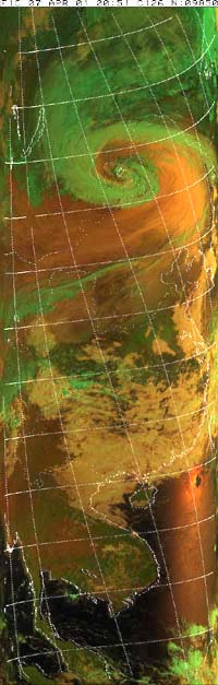
Fierce Sandstorms In the 2000 season twelve sandstorms hit Beijing . Li said at a news conference held earlier today (May 25) that sandstorms and suspended dust particles had invaded Beijing ten times so far this year and the current season was far from over. These sandstorms disrupt people's work, endanger their lives and cause significant economical loss. At times visibility was reduced to 1km or less. East coast cities such as Shanghai and Nanjing observed "muddy rain"; rain that came down with fine sand grains. But one recent sandstorm caught international attention when dust grains travelled across the Pacific Ocean. The enormous April 7 sandstorm brewed in an area bordering Inner Mongolia and China's neighouring country Mongolia. Under the watchful eye of FY-1C, the sandstorm migrated northeastward and began to affect the Korean Peninsula. A week later fine-grain dust particles reached North America. NASA's remote sensing satellites captured images which showed a veil of haze -- particulates from the Chinese sandstorm -- that stretched from Calgary in western Canada to Arizona in southwestern U.S. By the following day dust particles were found in the atmosphere over Florida. On Mar. 1 this year CMA placed its national sand and dust storms forecast system into a trial operation. Li explained that regional meteorological departments would combine data from all meteorological stations, which are now in a 24-hour operation, and hourly observations from FY-1C and its geostationary sister craft FY-2B to monitor storm development. Satellite observations over a large area are particularly important to fill the gaps in isolated regions where no ground meteorological stations exist. Sandstorm forecast is now included in the daily weather forecast that is disseminated through various media. Li said that CMA achieved a better sandstorm forecast accuracy for this season and managed to provide a forecast time of at least 24 to 48 hours before the storm strikes. The task of FY-1C in monitoring the formation and movement of sandstorms, and other environmental factors that contribute to their growth, becomes more vital in light of the assessment that a Washington-based environmental group released on Wednesday (May 23). The Earth Policy Institute issued a dired warning that "If China cannot quickly arrest the trends of deterioration, the growth of the dust bowl could acquire an irreversible momentum. What is at stake is not just China's soil, but its future." Spaceguard In addition to watching environmental phenomena on Earth, FY-1C takes measurements of conditions in space. The metsat carries a high energy particle detector on board to study solar particles which include heavy ions composition, proton energy spectrum and high energy electron integrated flux. The Centre for Space Sciences and Applied Research (CSSAR) of the Chinese Academy of Sciences (CAS) designed and built the detector. CSSAR scientists claim that this is the first time a single instrument can study a wide range of solar particles from proton to ions of iron, when usually two or three instruments are required for the same kind of study. The detector can measure protons in the energy range from 4 to 300 MeV and electron flux of over 2 MeV in the Earth's inner radiation belt. With the solar particle detector aboard, FY-1C joins a fleet of international satellites that collect space weather information. The information constitutes the daily space weather bulletin and is crucial in the current solar cycle 23 which sees the Sun peaks in its activities about a year ago. CAS and other foreign agencies use the space weather data to issue solar storm warnings, which are very useful in protecting orbiting spacecraft and in various terrestrial applications such as surge protection of a power grid. During the two years of operation, the instrument has accumulated a wealth of information on the global particle environment in low Earth orbit. For example data from the detector reveals a short- and long-term change in the distribution of high energy protons and electrons. Such information will help in understanding the origin and the capture and distribution mechanisms of heavy ions in the radiation belt, and in improving the modelling of the radiation belt. An improved model will benefit in designing better radiation-hardened spacecraft components as well as enhancing the safety of manned space missions. Related Links SpaceDaily Search SpaceDaily Subscribe To SpaceDaily Express  Beijing - May 20, 2001
For the first time in the Chinese meteorological satellite program, a metsat functions beyond its design life expectancy. The official Xinhua News Agency reported the milestone that Fengyun 1-C reached on May 10.
|
| ||||||||||
| The content herein, unless otherwise known to be public domain, are Copyright 1995-2016 - Space Media Network. All websites are published in Australia and are solely subject to Australian law and governed by Fair Use principals for news reporting and research purposes. AFP, UPI and IANS news wire stories are copyright Agence France-Presse, United Press International and Indo-Asia News Service. ESA news reports are copyright European Space Agency. All NASA sourced material is public domain. Additional copyrights may apply in whole or part to other bona fide parties. Advertising does not imply endorsement, agreement or approval of any opinions, statements or information provided by Space Media Network on any Web page published or hosted by Space Media Network. Privacy Statement All images and articles appearing on Space Media Network have been edited or digitally altered in some way. Any requests to remove copyright material will be acted upon in a timely and appropriate manner. Any attempt to extort money from Space Media Network will be ignored and reported to Australian Law Enforcement Agencies as a potential case of financial fraud involving the use of a telephonic carriage device or postal service. |