| . |  |
. |
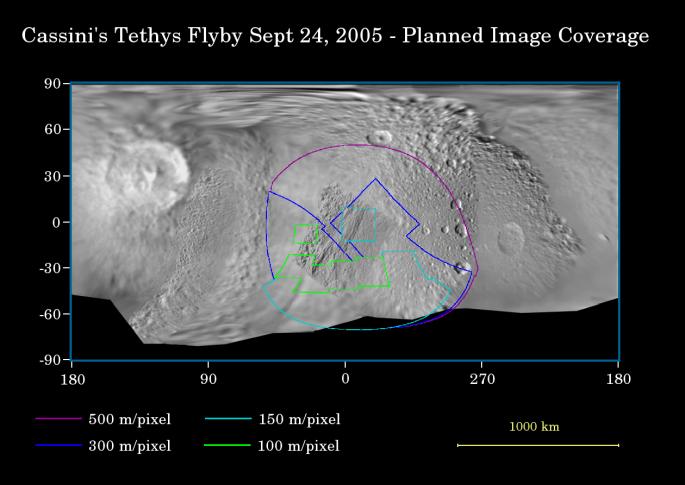
This map of the surface of Saturn's moon Tethys illustrates the regions that will be imaged by Cassini during the spacecraft's close flyby of the moon on Sept. 24, 2005. At closest approach, the spacecraft is expected to pass approximately 1,500 kilometers (930 miles) above the moon's surface. Tethys is 1,071 kilometers (665 miles) across. The colored lines delineate the regions that will be imaged at differing resolutions, listed in the legend at bottom. The new high-resolution coverage will reveal details on the Saturn-facing hemisphere of Tethys, including parts of the giant Ithaca Chasma canyon system. Imaging scientists also are hoping to obtain images of an ancient ridge east of Ithaca Chasma, as well as a section of terrain just west of the giant rift that appeared to be unusually smooth in NASA Voyager images. This flyby is also focused on gathering high-resolution imaging data of the moon's southern polar region. The map was made from images obtained by both the Cassini and Voyager spacecraft. Related Links Cassini-Huygens at JPL Cassini Imaging Team SpaceDaily Search SpaceDaily Subscribe To SpaceDaily Express 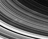 Boulder CO (SPX) Sep 19, 2005
Delighted scientists on the Cassini imaging team will be breaking out the champagne in celebration of the first Cassini sighting of spokes, the ghostly radial markings discovered in Saturn's rings by NASA's Voyager spacecraft 25 years ago.
|
| ||||||||||
| The content herein, unless otherwise known to be public domain, are Copyright 1995-2016 - Space Media Network. All websites are published in Australia and are solely subject to Australian law and governed by Fair Use principals for news reporting and research purposes. AFP, UPI and IANS news wire stories are copyright Agence France-Presse, United Press International and Indo-Asia News Service. ESA news reports are copyright European Space Agency. All NASA sourced material is public domain. Additional copyrights may apply in whole or part to other bona fide parties. Advertising does not imply endorsement, agreement or approval of any opinions, statements or information provided by Space Media Network on any Web page published or hosted by Space Media Network. Privacy Statement All images and articles appearing on Space Media Network have been edited or digitally altered in some way. Any requests to remove copyright material will be acted upon in a timely and appropriate manner. Any attempt to extort money from Space Media Network will be ignored and reported to Australian Law Enforcement Agencies as a potential case of financial fraud involving the use of a telephonic carriage device or postal service. |