| . |  |
. |
Largely natural "ups and downs" in a weather system centered near Iceland have contributed to regional variations and an overall decrease in Arctic sea ice cover over the last twenty years, according to new NASA research. As this semi-permanent low-pressure system intensifies and weakens, it affects the amount of air (generally warm) being brought into the Arctic to the east of the low and the amount of air (generally cold) being swept out of the Arctic to the west. These changes in turn affect the amount of ice cover in the respective regions, adding to the effects of climate warming. Claire L. Parkinson of NASA's Goddard Space Flight Center in Greenbelt, Md., highlights the changes in Arctic sea ice and their possible connection to the Icelandic low-pressure system in a paper appearing in the most recent issue of Polar Geography. Parkinson plotted the extent of sea ice using satellite passive-microwave data from 1979 through 1999. Data were analyzed from the Nimbus 7 satellite and three satellites of the Defense Meteorological Satellite Program (DMSP). Results confirm an overall decline in Arctic ice extent that has been connected with climate warming, but also show regional differences that suggest there are other influences. The "Icelandic Low" is a key to bringing a greater or lesser amount of warm air into the Arctic depending on the intensity of the system, and is part of a larger weather pattern called the North Atlantic Oscillation (NAO). NAO is the name for changes in the difference of air pressure between the semi- permanent low-pressure system centered near Iceland (the Icelandic Low) and a semi-permanent high-pressure system centered near the Azores Islands (better known as the Bermuda-Azores High). On average, both of these systems are present all year; however, both are strongest in winter. When both the high and the low intensify and fluctuate in pressure relative to one another, they change the circulation of cold and warm air in the region. When the Icelandic Low is strong, it forces cold Arctic air southward to the area west of Iceland and Greenland, setting the stage for increasing sea ice cover in Baffin Bay, the Labrador Sea, Hudson Bay and the Gulf of St. Lawrence. At the same time, to the east, warm air that is swept northward reduces ice extent. This warmer air contributes to the reduced ice extents east and north of Greenland, and the reduced extent of ice in the entire Arctic overall. "When the Icelandic Low is weak, it will still bring warm air northward to the east of Iceland, but not as much as when the Icelandic Low is strong," Parkinson said.
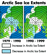
The strength of the Icelandic Low tended to increase from 1979 to 1990, then decrease in the 1990s. From 1979 to 1990 the ice cover to the east and north of the Low, in the Kara and Barents Seas and the Arctic Ocean, decreased, while the ice cover to the west of the Low, in Baffin Bay/Labrador Sea, Hudson Bay and the Gulf of St. Lawrence, increased. From 1990 to 1999 the situation was reversed, with the ice cover to the east and north of the Low increasing and the ice cover to the west of the Low decreasing. "This regional pattern of reversals in the ice extent trends is highly suggestive of an Icelandic Low impact, or, more broadly, of an impact from the North Atlantic Oscillation," Parkinson explained. "Still, the satellite data reveal an overall decrease in Arctic sea ice extent since 1978." The overall decrease in sea ice cover has generated questions about whether Arctic sea ice is being influenced by global warming. Parkinson urges caution in drawing conclusions for decreases in Arctic ice. "The trend of decreasing ice extent showed some signs of reversing in the 1990s," she noted. "Whether the ice cover as a whole will continue to exhibit the decreases that it experienced over the 1979 to 1999 period might depend on the strength and phase of the NAO, as well as on long-term trends in the climate system." Related Links SpaceDaily Search SpaceDaily Subscribe To SpaceDaily Express 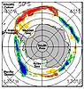 Greenbelt - Sept. 18, 2001
Scientists have been mystified by observations that when sea ice on one side of the South Pole recedes, it advances farther out on the other side. New findings from NASA's Office of Polar Programs suggest for the first time that this is the result of El Ninos and La Ninas driving changes in the subtropical jet stream, which then alter the path of storms that move sea ice around the South Pole. Secret to Earth's 'Big Chill' Found in Underground Water  Rochester - Sept 6, 2001
Scientists studying the oceans depend on data from rivers to estimate how much fresh water and natural elements the continents are dumping into the oceans. But a new study in the Aug. 24 issue of Science finds that water quietly trickling along underground may double the amount of debris making its way into the seas. This study changes the equation for everything from global climate to understanding the ocean's basic chemistry.
|
| ||||||||||
| The content herein, unless otherwise known to be public domain, are Copyright 1995-2016 - Space Media Network. All websites are published in Australia and are solely subject to Australian law and governed by Fair Use principals for news reporting and research purposes. AFP, UPI and IANS news wire stories are copyright Agence France-Presse, United Press International and Indo-Asia News Service. ESA news reports are copyright European Space Agency. All NASA sourced material is public domain. Additional copyrights may apply in whole or part to other bona fide parties. Advertising does not imply endorsement, agreement or approval of any opinions, statements or information provided by Space Media Network on any Web page published or hosted by Space Media Network. Privacy Statement All images and articles appearing on Space Media Network have been edited or digitally altered in some way. Any requests to remove copyright material will be acted upon in a timely and appropriate manner. Any attempt to extort money from Space Media Network will be ignored and reported to Australian Law Enforcement Agencies as a potential case of financial fraud involving the use of a telephonic carriage device or postal service. |
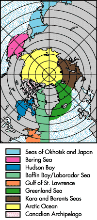 The study examined the ice in nine regions of Northern Hemisphere sea ice cover: the Arctic Ocean, the Kara and Barents Seas, the Greenland Sea, Baffin Bay/Labrador Sea, the Gulf of St. Lawrence, Hudson Bay, the Bering Sea, the Canadian Archipelago, and the Seas of Okhotsk and Japan.