| . |  |
. |
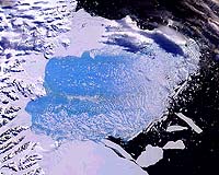
Recent NASA airborne measurements and a new review of space-based measurements of the thickness of Earth's polar ice sheets concludes they are changing much more rapidly than previously believed, with unknown consequences for global sea levels and Earth's climate. Large sectors of ice in southeast Greenland, the Amundsen Sea Embayment in West Antarctica and the Antarctic Peninsula are changing rapidly by processes not yet well understood, said researchers Dr. Eric Rignot of NASA's Jet Propulsion Laboratory, Pasadena, Calif., and Dr. Robert Thomas of EG&G Services at NASA's Wallops Flight Facility, Wallops Island, Va. Their study, published this week in the journal Science, reviews progress in measuring changes in ice sheet thickness based upon technical advances and observations made over the past decade. "Earth's polar ice sheets are changing over relatively short time scales, that is, decades versus thousands of years," Rignot said. Thomas added that today's more precise, widespread measurements tell us rapid changes are common. "These observations run counter to much accepted wisdom about ice sheets, which, lacking modern observational capabilities, was largely based on 'steady-state' assumptions," Thomas said. "Remote sensing is allowing researchers to look at polar processes on continental scales and in greater detail than before," said Dr. Waleed Abdalati, Cryospheric Program manager, NASA Headquarters. "Closer examination using even broader advanced remote sensing techniques, including NASA's upcoming Ice, Cloud and Land Elevation Satellite, the Gravity Recovery and Climate Experiment and Europe's planned Cryosat mission--combined with widespread interferometric synthetic aperture radar (InSAR) data, ice thickness surveys and ground-based measurements--will enable us to estimate ice sheet mass balance for Greenland and Antarctica even more precisely." Rignot said understanding how polar ice sheets evolve is vital to society. "The Antarctic and Greenland ice sheets together hold enough ice to raise sea level by 70 meters (230 feet)," he said. "Even a small imbalance between snowfall and discharge of ice and melt water from ice sheets into the ocean could be a major contributor to the current sea level rise rate of 1.8 millimeters (0.07 inches) a year and impact ocean circulation and climate. During past periods of rapid deglaciation, ice sheet melting raised sea level orders of magnitude faster than today. This is the real threat of the ice sheets." Rignot and Thomas' review summarizes current progress for two methods of measuring changes in ice sheet thickness: the mass budget method, which compares losses by melting and ice discharge with total net input from snow accumulation; and measuring elevation changes over time. These methods use various space remote sensing resources, such as laser and radar altimetry, the Global Positioning System and InSAR. The review reports Greenland's ice sheet is losing 50 cubic kilometers (12 cubic miles) of mass a year due to rapid thinning near its coasts. That's enough to raise sea level 0.13 millimeters (0.005 inches) annually. "Rapid coastal thinning cannot be explained by a few warm summers and is attributed to a dynamic ice sheet response," Rignot said. "A possible contributor to the observed trend is increased lubrication from additional surface melt water reaching glacier beds through crevasses and moulins." Rignot says the mass balance in Antarctica is much harder to calculate because the ice sheet is far larger, more remote and not well covered by existing key satellites. The researchers calculated net ice gains or losses for 33 Antarctic glaciers, including 25 of the 30 largest ice producers. The West Antarctic ice sheet was found to be thickening in the west, thinning rapidly in the north, and probably losing mass overall by roughly 65 cubic kilometers (roughly 15.5 cubic miles) a year, enough to raise sea level by about 0.16 millimeters (0.006 inches) a year. InSAR observations show several major glaciers that are accelerating and contributing to sea level rise. Radar altimetry shows ice shelves in the Amundsen Sea Embayment are rapidly thinning, possibly in reaction to a warmer ocean, as suggested by recent oceanographic data. Melting of ice shelf bottoms is far larger than expected here due to intrusion of warm water on the continental shelf, implying a larger interplay of ice and ocean in ice sheet evolution. Rignot said little is known about the mass balance of Antarctic Peninsula mountain glaciers, which receive a quarter of Antarctica's snow accumulation. The peninsula has warmed 2 to 3 degrees Celsius (3.6 to 5.4 degrees Fahrenheit) over the past 50 years, causing rapid thinning, enhanced melting and rapid disintegration of its ice shelves. The peninsula is a unique laboratory to determine whether retreating ice shelves can induce faster ice sheet flow and raise global sea level, a hypothesis formulated decades ago but still disputed. Recent results show large glacier acceleration in response to ice shelf collapse. If ice shelves do buttress glaciers, the Antarctic ice sheet's contribution to sea level rise could be much larger in the future than previously believed. Related Links SpaceDaily Search SpaceDaily Subscribe To SpaceDaily Express 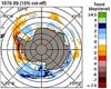 Greenbelt - Aug 26, 2002
While recent studies have shown that on the whole Arctic sea ice has decreased since the late 1970s, satellite records of sea ice around Antarctica reveal an overall increase in the southern hemisphere ice over the same period. Continued decreases or increases could have substantial impacts on polar climates, because sea ice spreads over a vast area, reflects solar radiation away from the Earth's surface, and insulates the oceans from the atmosphere.
|
| ||||||||||
| The content herein, unless otherwise known to be public domain, are Copyright 1995-2016 - Space Media Network. All websites are published in Australia and are solely subject to Australian law and governed by Fair Use principals for news reporting and research purposes. AFP, UPI and IANS news wire stories are copyright Agence France-Presse, United Press International and Indo-Asia News Service. ESA news reports are copyright European Space Agency. All NASA sourced material is public domain. Additional copyrights may apply in whole or part to other bona fide parties. Advertising does not imply endorsement, agreement or approval of any opinions, statements or information provided by Space Media Network on any Web page published or hosted by Space Media Network. Privacy Statement All images and articles appearing on Space Media Network have been edited or digitally altered in some way. Any requests to remove copyright material will be acted upon in a timely and appropriate manner. Any attempt to extort money from Space Media Network will be ignored and reported to Australian Law Enforcement Agencies as a potential case of financial fraud involving the use of a telephonic carriage device or postal service. |