| . |  |
. |
| . | |
. |
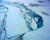
In efforts to determine how Antarctica is changing�whether due to natural or human-produced climate change�scientists use satellite and radar technologies to monitor the height and thickness of the continent's ice shelves. How are global warming and sea temperature changes affecting the thickness of these massive floating ice blocks? The height changes due to climate can be very small, perhaps only an inch or so per year. In contrast, the ocean tides that flow underneath ice shelves can push them up and down by several feet over the course of a day, and this large effect can make it difficult to measure the small climate-related changes with satellites. Now, researchers at Scripps Institution of Oceanography at the University of California, San Diego, and Earth and Space Research of Seattle have measured Antarctic ice shelf tides from space for the first time. Through their research, the effect of tides can be removed more accurately and thus climate-related changes can be tracked more closely. Helen Amanda Fricker of Scripps tapped information from the European Space Agency's European Remote Sensing (ERS) Satellite, which beamed radar signals to the Antarctic surface. Every 35 days, as the satellite orbited over Antarctica, the radar signals would hit the ice shelves and bounce back to the satellite, allowing scientists to calculate how the height of the ice shelves was changing. On floating ice, surface height can be used to estimate the ice thickness. Fricker's information was combined with calculations for Antarctic tides developed by Laurie Padman of Earth and Space Research, together setting the groundwork for a clear measurement of how the ice shelves change. "Ice shelves are floating ice blocks, so if the ocean underneath them is warming, it will increase the melting under the ice shelves and the ice is going to get thinner," said Fricker, of the Cecil H. and Ida M. Green Institute of Geophysics and Planetary Physics at Scripps. "Antarctic ice shelves can be sensitive areas in terms of climate change. We want to monitor their thickness and see if they're in steady-state or whether they are changing with time because of changes in climate." Fricker said the ice shelves can play a critical role in buttressing, or holding back, ice from detaching from the Antarctic continent. Removing them, she said, may increase the flow of ice off the continent. "As that ice melts, it will increase sea level around the world. It's important to monitor not only the grounded ice on the continent and how that's changing, but the floating ice as well," said Fricker. "To do this, we need accurate repeat measurements of ice shelf height and we have to remove the tidal signal because that will mask the true ice shelf elevation." Fricker and Padman's analysis served as a successful "proof of concept" for upcoming studies investigating Antarctic ice shelves and climate change. The collaborative study, published in a recent issue of Geophysical Research Letters (GRL), details their analysis of eight years' worth of ERS information using radar altimeter data concentrated on the 500-mile-wide Filchner-Ronne Ice Shelf in Antarctica's Weddell Sea. "This was a first attempt," said Padman. "Now that we have these results we are encouraged to improve our model of tides by using more sophisticated analysis techniques and combining the new data with numerical models based on the physics of ocean tides." The next step will take the form of a new satellite called ICESat being prepared by NASA for launch later this year. A new instrument on ICESat, the Geoscience Laser Altimeter System (GLAS), will be the first to measure ice shelves using a sophisticated space-based laser instrument. GLAS will beam laser pulses 40 times per second, from approximately 400 miles above the Earth's surface, and time each pulse to determine the surface height with an accuracy of better than six inches. Over time this will result in a determination of the surface height change with an accuracy of better than half an inch per year. "GLAS will be the first spaceborne laser altimeter to cover Antarctica. It will have a much smaller footprint on the ground than the radar altimeter and be able to give us much more accurate measurements than ERS," said Fricker. Related Links Scripps National Science Foundation Office of Polar Programs SpaceDaily Search SpaceDaily Subscribe To SpaceDaily Express  University Park - Jul 26, 2002
Variability in the speed of the ice streams along the Siple Coast of West Antarctica is not an indication the ice sheet is stabilizing, but rather, that capriciousness in the ice streams, their rates and the location of the grounding line is normal and will continue to occur, according to Penn State geoscientists.
|
| ||||||||||
| The content herein, unless otherwise known to be public domain, are Copyright 1995-2016 - Space Media Network. All websites are published in Australia and are solely subject to Australian law and governed by Fair Use principals for news reporting and research purposes. AFP, UPI and IANS news wire stories are copyright Agence France-Presse, United Press International and Indo-Asia News Service. ESA news reports are copyright European Space Agency. All NASA sourced material is public domain. Additional copyrights may apply in whole or part to other bona fide parties. Advertising does not imply endorsement, agreement or approval of any opinions, statements or information provided by Space Media Network on any Web page published or hosted by Space Media Network. Privacy Statement All images and articles appearing on Space Media Network have been edited or digitally altered in some way. Any requests to remove copyright material will be acted upon in a timely and appropriate manner. Any attempt to extort money from Space Media Network will be ignored and reported to Australian Law Enforcement Agencies as a potential case of financial fraud involving the use of a telephonic carriage device or postal service. |