| . |  |
. |
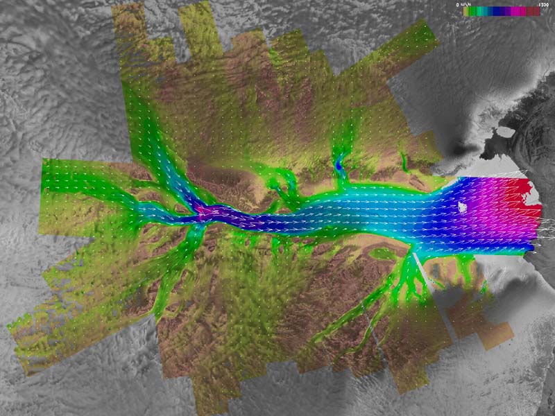
Images produced by Canada's Radarsat-1 is helping scientists study the rate and extent of climate change in Antarctica. Early analyses show that in just three years the Amery Ice Shelf has advanced five kilometres, while the Shirase Glacier has retreated twelve kilometres. Scientists are seeking to understand whether this variability is due to the forces of external climate on the great ice sheet or due to natural and episodic instabilities that arise from the forces that control complex glacier flow. The new velocity measurements from this second completed mission will help answer these questions. "The Antarctic Ice Sheet moves slowly and surely under the force of its own enormous weight," says Principal Scientist Dr. Kenneth C. Jezek of The Ohio State University's Byrd Polar Research Center. "This mission gives us the first, overall snapshot of how the ice moves and important new insight into how and why the ice sheet is changing. Moreover, by measuring the extent and velocity of the moving ice and estimating its thickness, we can estimate how much ice may be lost into the ocean from Earth's largest storehouse of freshwater. These calculations are important for understanding Antarctica's contribution to the present rate of sea level rise of about two millimeters a year." For this mission, the Canadian Space Agency's RADARSAT-1 satellite trained its imaging radar on the outer half of the continent twice during each of three consecutive 24-day periods, ending last Nov. 14. "This was a challenging mission for our professionals who had to accurately navigate the satellite, controlling the 800 kilometre orbit, while periodically firing the spacecraft's onboard thrusters so as to position the satellite within a few hundred meters of its nominal track on each orbit," said Rolf Mamen, Director General of Space Operations at the Canadian Space Agency. Precise navigation and data from the six passes make it possible to create detailed topographic maps and to measure the speed of the moving glaciers. The two scientific missions supported by RADARSAT-1 have produced a new baseline dataset for the scientific community -- one that will prove invaluable in monitoring the state of the Antarctic ice cap. And although RADARSAT-1 is being exploited by the Canadian Space Agency beyond its nominal lifetime, this same leading-edge technology continues to produce outstanding imagery is also being brought to bear on studies of polar ice in Canada's Arctic region. RADARSAT-2, currently under construction for the Canadian Space Agency by MacDonald Dettwiler and Associates of British Columbia and scheduled for launch in 2003, will contribute to expanding the vast data archive already captured by RADARSAT-1. The Antarctic Mapping Mission is a joint project between NASA and the Canadian Space Agency. The project is led by Ohio State University in Columbus in partnership with the Alaska Synthetic Aperture Radar (SAR) Facility at the University of Alaska Fairbanks, NASA's Jet Propulsion Laboratory, Pasadena, Calif., and the Vexcel Corporation, Boulder, Colo. Related Links More Pixs The Mission The Canadian Space Agency SpaceDaily Search SpaceDaily Subscribe To SpaceDaily Express  Pasadena - March 16, 2001
Scientists have had their first inside look at ice layers, frozen debris and a surprising channel of water deep beneath an Antarctic ice stream, thanks to an ice probe designed by NASA's Jet Propulsion Laboratory, Pasadena, Calif. Plunged more than 1,200 meters (more than 3,900 feet) down four boreholes drilled in the West Antarctic ice sheet, JPL's probe paves the way for the development of technology capable of withstanding extreme environments on Earth and other planets.
|
| ||||||||||
| The content herein, unless otherwise known to be public domain, are Copyright 1995-2016 - Space Media Network. All websites are published in Australia and are solely subject to Australian law and governed by Fair Use principals for news reporting and research purposes. AFP, UPI and IANS news wire stories are copyright Agence France-Presse, United Press International and Indo-Asia News Service. ESA news reports are copyright European Space Agency. All NASA sourced material is public domain. Additional copyrights may apply in whole or part to other bona fide parties. Advertising does not imply endorsement, agreement or approval of any opinions, statements or information provided by Space Media Network on any Web page published or hosted by Space Media Network. Privacy Statement All images and articles appearing on Space Media Network have been edited or digitally altered in some way. Any requests to remove copyright material will be acted upon in a timely and appropriate manner. Any attempt to extort money from Space Media Network will be ignored and reported to Australian Law Enforcement Agencies as a potential case of financial fraud involving the use of a telephonic carriage device or postal service. |