| . |  |
. |
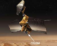
for Washington University in St. Louis St. Louis MO (SPX) Mar 03, 2006 Two Mars orbiter missions - one from NASA, the other from the European Space Agency (ESA) - will open new vistas in the exploration of Mars through the use of sophisticated ground-penetrating radars, providing international researchers with the first direct clues about the Red Planet's subsurface structure. Roger Phillips, Ph.D., Washington University in St. Louis Professor of Earth and Planetary Sciences in Arts & Sciences, is participating in both the Mars Express (ESA) and NASA's Mars Reconnaissance Orbiter (MRO) missions by lending his expertise in radar. Phillips says that the combination of the radars on the two missions will provide important and unique data sets that will directly map the structure of the upper portions of the interior of Mars. The Mars Reconnaissance Orbiter (above) is poised to go into orbit around Mars in March, then spend about six months aerobraking to place the spacecraft in a low circular orbit by this fall. Roger Phillips, Ph.D., WUSTL professor of earth and planetary sciences and director of the university's McDonnell Center for the Space Sciences, is lending his expertise in radar for both the MRO and for the European Space Agency's Mars Express. Mars Express features an instrument called the Mars Advanced Radar for Subsurface and Ionospheric Sounding (MARSIS); Mars Reconnaissance Orbiter's radar instrument is called the Shallow Subsurface Radar (SHARAD). Both instruments have been built primarily by the Italian Space Agency, and, says Phillips, they are complementary. Mars Express went into orbit on Christmas Day of 2003, but the radar developed some technical problems and didn't start operating until the summer of 2005. One of the problems was making sure that the craft's long antennas would unfold without damaging the spacecraft. This necessitated a full stop, followed by many hardware and computer simulations until confidence was gained that the antennas could be deployed safely. The first data were published in the journal Science late last year, with Phillips a co-author along with approximately 30 European and American colleagues. "One of the spectacular results of that paper is the fact that we've sounded the northern polar cap of Mars, the radar signals penetrating all the way to the bottom of the icy cap and bouncing back so that we can see right down to the cap's base, nearly two kilometers deep," Phillips says. "This result tells us that we will eventually be able to map the volume of both the northern and southern ice caps, which will provide a much better understanding of the origins and evolution of these features and the amount of water that is tied up frozen in the caps. The radar is looking inside the planet directly - that's never been done before on Mars." The northern cap data also provide the Mars Express team with the first direct observation of how the load of the ice cap deforms the planet's underlying crust - a phenomenon called flexure. There is in fact no flexure observed within the error limits of the radar data, which means that the crust beneath the northern polar cap is very strong, says Phillips. "That also tells us that the heat output of the planet at present is quite low. There have been theoretical models predicting this, but never a direct observation until now. " Finding unfrozen subsurface water is a possibility, too; this is the Holy Grail of MARSIS, Phillips says. "At the boundary of a water-rich environment we should see a very strong reflection. Whether we find such a reflector remains to be seen - we're in the early days of gathering data. Right now MARSIS is carrying out a campaign to map the structure of the southern polar cap." Phillips says that the MARSIS radar also has mapped buried impact craters, which should revise the theory of how old the martian crust is and how it evolved. SHARAD will likely not probe as deeply as MARSIS, but it has ten times the vertical resolution, allowing for opportunities to map detailed subsurface stratigraphy, says Phillips, who is also director of Washington University's McDonnell Center for the Space Sciences The MRO spacecraft is now poised to go into orbit around Mars in March, and will then spend about six months aerobraking to place the spacecraft in a low circular orbit by this fall. This will mark the start of a two-year mapping campaign that NASA calls the primary science phase. Phillips is Deputy Team Leader for the MRO SHARAD experiment. The Team Leader is Roberto Seu, Ph.D., of the INFOCOM Department at the University of Rome, La Sapienza, Italy. "I think that SHARAD will be an excellent mapper of the sedimentary layers on Mars, and that will help us better understand the water history of the planet, "Phillips says. "One of my hopes is to connect what SHARAD maps in the subsurface in the Terra Meridiani area to the sulfate-rich stratigraphy that has been seen there by the Mars Exploration Rover (MER) Opportunity. This will help place the local stratigraphy at the MER landing site into a more regional context and help refine hypotheses for the origins of these enigmatic sedimentary rocks." Related Links Mars Reconnaissance Orbiter
 Pasadena CA (SPX) March 1, 2006
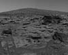
NASA's Spirit recorded this view while approaching the northwestern edge of the formation Mars Exploration Rover mission controllers have named Home Plate, a circular plateau-like area of bright, layered outcrop material roughly 80 meters (260 feet) in diameter. |
|
| The content herein, unless otherwise known to be public domain, are Copyright 1995-2006 - SpaceDaily.AFP and UPI Wire Stories are copyright Agence France-Presse and United Press International. ESA PortalReports are copyright European Space Agency. All NASA sourced material is public domain. Additionalcopyrights may apply in whole or part to other bona fide parties. Advertising does not imply endorsement,agreement or approval of any opinions, statements or information provided by SpaceDaily on any Web page published or hosted by SpaceDaily. Privacy Statement |