| . |  |
. |
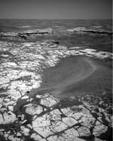
Pasadena CA (JPL) Jun 19, 2006 After the previous week's successful extraction from Jammerbugt, Opportunity resumed its drive southward on the Meridiani Planum toward Victoria Crater. NASA's Mars rover covered approximately 95 meters (312 feet) last week, and reached the five-mile mark for total odometry. This week, Opportunity will be on restricted sols, meaning the end-of-sol data from the rover will not reach Earth until late in the day, so the mission team must plan every other day without it. Consequently, controllers are planning for Opportunity to drive every other day. On the days off, they will order the rover to conduct light remote sensing and downlink some of the unsent data that has been accumulating in its memory. Sol-by-sol summaries Sol 844 (June 9): Opportunity drove 20 meters (66-feet). Planners directed Opportunity south, down the next trough over from the previous drive. The drive stopped after 4.8 meters (16 feet), when the first slip check detected a 42 percent slip, compared with the maximum allowed 40 percent. Sol 845: The rover conducted targeted remote sensing, including panoramic camera imaging of targets called Jylland and Gorm, and an observation of Gorm with the miniature thermal emission spectrometer. The team is informally naming targets in honor of Danish Constitution Day (June 5). Jylland is the main island of the Danish peninsula, and Gorm was the first king of Denmark. Sol 846: After little progress in two adjacent troughs, Opportunity moved one more trough to the west. Slip checks were used to prevent driving with over 40 percent slip. The soil was relatively firm, and the rover made 9 meters (30 feet) of progress. Sol 847: Opportunity conducted atmospheric science and took rear-looking images with its navigation camera. Sol 848: The drive took Opportunity down a trough. The team turned the rover around on a piece of outcrop so that it could drive backwards (to improve UHF data return). The drive proceeded down the trough and made 20.6 meters (68 feet) of progress. Before the drive, the panoramic camera took an image of a small crater, nicknamed Sjaelland for the biggest island of Denmark and the site of the capital. Sol 849: Continuing south, Opportunity made 24 meters (79 feet) of progress. Slip checks were done approximately every 5 meters (16 feet) while on sand. The drive ended on a patch of outcrop. Sol 850: To start the day, Opportunity took a panoramic camera image of target Steno (informally named for Niels Steensen, or Nicholas Steno, a 17th century Danish anatomist and geologist). The drive was completed entirely over outcrop, and approximately 36 meters (118 feet) of progress was made. Opportunity performed one bonus slip check, on an area with a little more sand than the rest. As expected, very little slip was detected. Sol 851 (June 16): Plans called for driving farther south. Opportunity's odometry as of sol 850 (June 15) totaled 8,080.38 meters, or 5.02 miles. Related Links Mars Rovers at JPL Mars Rovers at Cornell
 Washington (UPI) Jun 16, 2006
Eighteen middle school and high school U.S. science teachers will soon depart for Alaska for a Mars exploration and polar science research experience. The teachers, selected from more than 500 applicants to join the June 23 Phoenix Mars Mission team, will perform scientific investigations in the Cold Regions Research and Engineering Laboratory's permafrost tunnel and at University of Alaska-Fairbanks research labs. |
|
| The content herein, unless otherwise known to be public domain, are Copyright 1995-2006 - SpaceDaily.AFP and UPI Wire Stories are copyright Agence France-Presse and United Press International. ESA PortalReports are copyright European Space Agency. All NASA sourced material is public domain. Additionalcopyrights may apply in whole or part to other bona fide parties. Advertising does not imply endorsement,agreement or approval of any opinions, statements or information provided by SpaceDaily on any Web page published or hosted by SpaceDaily. Privacy Statement |