. 24/7 Space News .
Mouth of the mighty Yangtze

This image covers the region of Shanghai in China. The city of Shanghai lies on the south bank of the Yangtze River mouth throwing itself into the East China Sea. The Yangtze River is the longest river in Asia, about 950 kilometers of its 6300 total length are navigable, which makes it an extensive and important transport network. The Yangtze River and its branches and the many lakes are a major source for drainage.

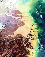
Paris - Mar 26, 2004
The coloured waters shown here in this 21 March Envisat Medium Resolution Imaging Spectrometer (MERIS) image have concluded a long journey across China.

They are surging into the East China Sea from the mouth of the Yangtze River, which at 6300 km long is the longest river in Asia and the third longest in the world.

Rising in the Qinghai-Tibetan Plateau, the Yangtze River snakes through nine provinces and serves as a drain for 1.8 million square kilometres of territory. MERIS is designed to detect ocean colour, and clearly visible here is how the Yangtze's heavy sediment plume discharges into and colours the waters along the Chinese coast. Its total sediment load is estimated at 680 million tonnes a year � equivalent in weight to a hundred Great Pyramids.

Shanghai - China's largest city - is located south of the Yangtze mouth and the 1000-km-long navigable stretch of the Yangtze west of it is a zone of major economic activity.

The downside of recent growth has been a decrease in water quality that the Chinese government say it intends to combat. At the start of the month an accidental chemical spill into a tributary of the Yangtze temporarily deprived almost a million people of drinking water.

Related Links
Envisat
SpaceDaily
Search SpaceDaily
Subscribe To SpaceDaily Express


Memory Foam Mattress Review
Newsletters :: SpaceDaily :: SpaceWar :: TerraDaily :: Energy Daily
XML Feeds :: Space News :: Earth News :: War News :: Solar Energy News


NASA Uses A "Sleuth" To Predict Urban Land Use
Greenbelt MD - Mar 26, 2004
According to NASA-funded researchers, developed land in the greater Washington-Baltimore metropolitan area is projected to increase 80 percent by 2030. Scientists used a computer-based decision support model loaded with NASA and commercial satellite images to simulate three policies affecting land use.


  • Docking With Precision
  • Europe And Russia: A 15-Year Partnership In Human Spaceflight
  • The Bush Space Initiative: Fiscal Nightmare or... Fiscal Nightmare?
  • Space Adventures Scouting Potential Locations For Sub-Orbital Spaceport

  • Martian Spiral Mystery At Poles Explained
  • "Rover and Track" Makes Its Debut
  • Opportunity Finds Beachfront Property on Mars
  • Analysis: Mars water discoveries loom huge

  • NASA's X-43A Hypersonic Aircraft Ready For Flight
  • NASA Looks To Department Of Energy For Nuclear Space Tech Support
  • The Making Of An Ariane 5 Launch
  • ILS To Launch NRO Mission as First Atlas V Flight from Upgraded Pad

  • EU Competitiveness Council Debates Space Policy
  • NASA Uses A "Sleuth" To Predict Urban Land Use
  • Mouth of the mighty Yangtze
  • Land Cover Changes Affect U.S. Summer Climate

  • Gravity Rules: The Nature of Planethood
  • Enigma Of Uranus Solved At Last
  • Latest Kuiper Belt Object Could Be Biggest Yet
  • The Colorful Lives Of The Outer Planets

  • Smart-1 Eclipse Period Over
  • NASA's New Vision Inspires Students In Great Moonbuggy Race
  • Interstellar Hydrogen Shadow Observed For The First Time
  • Three-Ton Science Experiment To Cruise South Pole Skies For Cosmic Rays

  • Armstrong Reflects On A New Visions For Space Exploration
  • Sunny lunar mountain good site for base
  • Lunar Convoys As An Option For A Return To The Moon
  • NASA Planning Steps To Moon, Mars

  • Boeing Delta II Deploys 50th GPS Satellite
  • European Parliamentarian McNally Urges Support For Space
  • GPS 2R-11 Satellite Dedicated to Ivan A. Getting
  • TrimTrac Wins Best Bang For The Buck Awarded In GPS Vehicle Tracking

  • The content herein, unless otherwise known to be public domain, are Copyright 1995-2006 - SpaceDaily.AFP and UPI Wire Stories are copyright Agence France-Presse and United Press International. ESA PortalReports are copyright European Space Agency. All NASA sourced material is public domain. Additionalcopyrights may apply in whole or part to other bona fide parties. Advertising does not imply endorsement,agreement or approval of any opinions, statements or information provided by SpaceDaily on any Web page published or hosted by SpaceDaily. Privacy Statement