| . |  |
. |
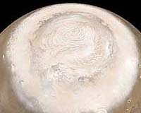
Moffett Field (SPX) Sep 22, 2006 Michael Meyer, lead scientist for NASA's Mars Exploration Program, spoke at the recent Viking anniversary celebration. In part two of this edited transcript, Meyer provides an overview of upcoming martian missions. Like the Viking mission thirty years ago, these future missions all aim to improve our understanding of the Red Planet and its potential for life. "The Mars Reconnaissance Orbiter got into orbit around Mars in March and is now aerobraking. Hopefully all of its instruments will be deployed in the beginning of October. Unfortunately, the planet then becomes occulted by the sun, so we're not going to be able to talk to it for awhile, but come November we'll be in a science orbit and we'll start streaming back the data. MRO has a very ambitious plan: two years of science observation and two more years of relay. That's not to say that during a relay it's also not doing science, but with Phoenix going and landing in 2007, and also Mars Science Laboratory going in 2009, we want MRO with its fantastic data streaming capabilities to help our landed missions. MRO has a wide range of instruments and many objectives. The Climate Sounder will look at seasonal cycles and variations in water. We'll look at atmospheric structure and at minerals. The high resolution camera will look at the geology -- the stratigraphy and the morphology. We'll look at the profile of the upper crust and the subsurface water with radar, which will have a higher resolution than the one on Mars Express. We'll be able to measure the planet's gravitational field. One of the top objectives is to image future landing sites, particularly for Phoenix and Mars Science Laboratory. Because of the higher resolution camera, we'll be able to identify gullies and debris fans. With the high resolution near-infrared, we'll be able to identify the thin layering we've seen from Mars Orbital Camera, and who knows, maybe we'll even see some remnants of hot springs or vents and things of that nature. So we're just on the edges of our seats waiting for MRO to get into that mapping orbit. It's like putting our glasses on and looking at the world again for the first time. Next will be Phoenix, a competed Scout mission that is getting ready to be launched in 2007. This mission doesn't have wheels - it's not a rover - and it's going to the poles. We expect to land in a place with layered terrain that has several tens of centimeters of regolith, or soil on top, and underneath it, ice. We hope these layers will give us some hint of what has been going on in the near past, but we have no idea what sort of time frame we'll be able to sample in the upper meter of soil and ice. Phoenix will look at the polar dynamics, and see how the poles have changed not only on a seasonal basis but a decadal basis or even longer, depending on how thin or how representative the layers are over time. There's a meteorology package to see how the atmosphere interacts with the surface. Also, Phoenix will determine if there is a remnant habitable zone. We don't expect the polar areas to be habitable today, but the past climate variations may have made the planet warm enough. Concentrations of atmospheric dust or organics left in the soil may provide a record of this past habitable environment. In figuring out the landing site, one of the advantages to having orbiters around the planet for an extended period of time is now you can do time-lapsed photography. For instance, the polar area might be completely covered in frost, but one month later the surface frost is gone. Now you can see some details of the subsurface, and see that some frost has remained in the cracks. So that gives you a much better idea of what the terrain is like, and whether or not it's safe for this particular lander. Phoenix is going to access its samples through a scoop. One problem is that as ice gets colder it gets harder, and trying to scoop that ice could be difficult. You can imagine just scratching the ice and never getting a sample. So the project team added a robotic drill, or rasp, to serve as a snowcone maker. You rest it against the ice and turn it on, and it routes the ice into little flakes. So you end up with a pile of snow sitting in the scoop to be analyzed. Phoenix also has a camera that's able to look at the sand grains, and with that we can learn about the history of ice in the soil and how the polar climate has waxed and waned. Looking at the grains will give us some idea if the surrounding area has ever been habitable. The next mission is Mars Science Laboratory. This will be the first analytical roving laboratory. It's still a mission concept because we haven't come to a resolution of whether or not it will be a radioisotope power source, but this is not your MER rover. MSL is about the size of a Mini Cooper. If we want to talk about vehicles and comparison, the MER is like a van, while MSL is like an RV. It has the advantage of having a kitchen inside so you can do your cooking. Just looking at the mass of it, you're about 4 or 5 times the mass of MER. The design lifetime is going to be much longer. Considering how long the Spirit and Opportunity rovers have lasted beyond their design lifetimes, it almost boggles the mind to think how long MSL could last. It may be there to greet the astronauts when they arrive on Mars. One of the things that I'm really pleased about is that while MER has 5.5 kilograms of instruments onboard each rover, MSL will have 75 kilograms. It's a very robust and complicated suite, and it enables us to do some measurements that I think are key to understanding what's happening on Mars. On the mast we have ChemCam and Mastcam. Mastcam is basically a stereo color imager to see the area around us. It also has the capability to zoom in and to make movies, which may be particularly interesting for dust devils or anything else that moves on the surface. ChemCam is a laser-induced breakdown spectrometer. What that means is a laser will "zot" a rock that is within 9 meters. The laser turns a spot on the rock into plasma, and the spectrometer can look at the plasma and read the elemental composition. So with ChemCam you don't have to go completely up to a particular rock that you're interested in sampling. We also have contact instruments that are similar to what is on the MER rovers. We have an alpha particle X-ray spectrometer, which gives you elemental composition when you place it up against a rock or soil. But the integration time is much less, so that will be helpful in speeding up that operation. We have a microscopic imager, and it's about two and a half times the resolution of the imager that's on MER. It also has its own light source, including UV. So that should help in finding differences between mineral grains, and maybe even being able to identify what the mineral grains are. We have instruments for environmental characterization. One of them is MARDI, a descent imager. That will give us great context as the rover lands so that on day one or two, we'll have a reasonable idea of where we want to go first. REMS is a remote environmental monitoring system, a meteorological experiment that will give us wind speed, humidity, temperature, also measure UV radiation. DAN, the neutron backscatter instrument, will measure the missing neutrons coming back off the surface, so it tells you where there's hydrogen. Basically it will monitor the amount of water in the upper meter of the surface. And then, with a broad spectrum sensor for radiation, for the first time we can correlate what we've seen from orbit of the type of radiation hitting the martian surface. This is particularly important for understanding how nasty of an environment it is for humans to go explore in. The centerpiece of the mission is the analytical lab. One component is Chemin, an X-ray diffraction/fluorescence instrument that tells you mineralogy. If you were a geochemist and you want to know what a mineral was, this is the instrument you would use. We've done very well with MER in identifying some minerals, but as the science team will tell you there are times when they're not quite sure what the mineral is. By identifying the mineral, you can tell the history of that particular sample. As you can imagine, this becomes more important as you're trying to determine the past habitability of the environment that you're studying. The rock is the only thing that's going to have a record of what that environment might have been like. SAM is a gas chromatograph mass spectrometer plus a tunable laser system. It can measure the atmosphere, gives us isotopes, look at carbon monoxide, water, methane. When it lands, within a very short time it will confirm or deny whether there is methane in the atmosphere of Mars. One lingering mystery about the Viking science results is not finding organics on the surface of Mars. You can have organics in an oxidized environment -- what you're left with are very refractory materials on the order of graphite. But Viking may not have been able to measure some highly refractory materials. With its high molecular capability and pyrolysis capability, SAM will be able to tell if there are any organics on the surface at all, even something highly refractory that's left over from a long period of time. MSL, by brushing the surface or by drilling cores, may be able to see if there are places where organics have been preserved. I think that's a major step forward. If we find organics, that will help us understand whether or not Mars not only was habitable, but also whether or not life could have gotten started. One of the things we've found studying life here on Earth is that life not only needs water, but also needs organics for any of the complex organic chemistry that all living systems use." Related Links Mars Reconnaissance Orbiter Mars News and Information at MarsDaily.com
 Pasadena CA (SPX) Sep 22, 2006
The Mars Society is holding an International Mars Rover Challenge Competition. The contest, which is open to student teams from universities around the world, will require students to build prototype rovers and operate them remotely in an undeveloped desert area in the American west. |
|
| The content herein, unless otherwise known to be public domain, are Copyright 1995-2006 - SpaceDaily.AFP and UPI Wire Stories are copyright Agence France-Presse and United Press International. ESA PortalReports are copyright European Space Agency. All NASA sourced material is public domain. Additionalcopyrights may apply in whole or part to other bona fide parties. Advertising does not imply endorsement,agreement or approval of any opinions, statements or information provided by SpaceDaily on any Web page published or hosted by SpaceDaily. Privacy Statement |