| . |  |
. |
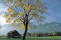
Tuscon - Feb 25, 2004 University of Arizona researchers have created a Web site that allow users to compare greenness from one year to the next, between years, against a 14-year average and at two-week intervals. The information is invaluable for making long-term land management decisions. Ranchers, forest rangers and other natural resource managers work directly on the land nearly every day to observe changes and decide how to handle them, whether grazing cattle, monitoring wildlife or assessing fire danger. In combination with this site-specific approach, a University of Arizona satellite image database called RangeView offers these managers a bird's-eye view of broader terrain. "RangeView provides frequent satellite images online to enhance the ability of natural resource managers, including ranchers, to manage the landscape," says Chuck Hutchinson, director of the Arizona Remote Sensing Center (ARSC), part of the Office of Arid Lands Studies (OALS) in the UA College of Agriculture and Life Sciences. Along with Stuart Marsh, professor of arid lands, and arids-lands researcher Barron Orr, Hutchinson created the Web site to display NASA digital images in configurations that allow users to analyze the characteristics of the land. Orr says, "This tool offers the ability to zoom in on your ranch, forest or habitat and monitor changes in vegetation through time." George Ruyle, Larry Howery and Paul Krausman, faculty from the UA School of Natural Resources, and Mark Enns from the UA department of animal sciences, provided additional input. Hitting the "animate" button to see two-week variations in vegetation over the past year can assess fire potential or other time-dependent applications. To orient themselves, viewers can look at the location of towns, roads, grazing allotments and other features. Finding out that the program can zoom in on geographic areas that are familiar to them often dispels any qualms users may have about learning a new computer application. "Our members are so familiar with the land. When you get them looking at a view of it from space, they forget they're using a computer mouse and want to get that cursor arrow on their ranch," says Doc Lane, director of natural resources for the Arizona Cattlemen's Association and Arizona Wool Producers Association. "You'd be amazed how quickly people forget they're using a computer and connect directly with their ranch on the screen." Though the U.S. Geological Survey has been producing this "vegetation index" from National Oceanic and Atmospheric Administration satellite data since 1989, this is the first time it has been made easily accessible for the general public, the researchers say. Resolution on the satellite images is one square kilometer, enough to show vegetation color without violating people's privacy. Hutchinson says the capability of the site is somewhere between weather information that is not very site-specific and field monitoring that is quite site-specific. "This is something in the middle that can bridge those two scales." RangeView images are available for the entire United States, southern Canada and northern Mexico. With funds that are managed by Raytheon, NASA's Office of Earth Science supports the Web site. Begun in 1999, the site is still being adapted and modified to suit its target audiences. RangeView is the centerpiece of a geospatial UA Cooperative Extension program taught at workshops across Arizona. In addition to research and Cooperative Extension efforts, RangeView is supporting graduate and undergraduate student research in a diverse set of programs, including range sciences, wildlife science, the Arid Lands Resource Sciences doctoral program, mathematics, international studies and geography. "Undergraduates get a real research and development experience while they're going to school," Marsh says. "They are face-to-face with the people who benefit, which doesn't usually happen." Related Links Range View site Arid Lands Studies Arizona Remote Sensing Center SpaceDaily Search SpaceDaily Subscribe To SpaceDaily Express
 Paris (ESA) Feb 25, 2004
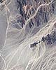
Visible from ESA's Proba spacecraft 600 kilometres away in space are the largest of the many Nasca Lines; ancient desert markings now at risk from human encroachment as well as flood events feared to be increasing in frequency. |
|
| The content herein, unless otherwise known to be public domain, are Copyright 1995-2006 - SpaceDaily.AFP and UPI Wire Stories are copyright Agence France-Presse and United Press International. ESA PortalReports are copyright European Space Agency. All NASA sourced material is public domain. Additionalcopyrights may apply in whole or part to other bona fide parties. Advertising does not imply endorsement,agreement or approval of any opinions, statements or information provided by SpaceDaily on any Web page published or hosted by SpaceDaily. Privacy Statement |