| . |  |
. |
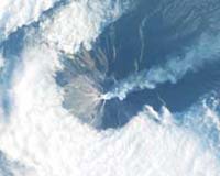
Huntsville AL (SPX) Oct 30, 2006 The Indonesian volcano Talang on the island of Sumatra had been dormant for centuries when, in April 2005, it suddenly rumbled to life. A plume of smoke rose 1000 meters high and nearby villages were covered in ash. Fearing a major eruption, local authorities began evacuating 40,000 people. UN officials, meanwhile, issued a call for help: Volcanologists should begin monitoring Talang at once. Little did they know, high above Earth, a small satellite was already watching the volcano. No one told it to. EO-1 (short for "Earth Observing 1") noticed the warning signs and started monitoring Talang on its own. Indeed, by the time many volcanologists were reading their emails from the UN, "EO-1 already had data," says Steve Chien, leader of JPL's Artificial Intelligence Group. EO-1 is a new breed of satellite that can think for itself. "We programmed it to notice things that change (like the plume of a volcano) and take appropriate action," Chien explains. EO-1 can re-organize its own priorities to study volcanic eruptions, flash-floods, forest fires, disintegrating sea-ice-in short, anything unexpected. Is this real intelligence? "Absolutely," he says. EO-1 passes the basic test: "If you put the system in a box and look at it from the outside, without knowing how the decisions are made, would you say the system is intelligent?" Chien thinks so. And now the intelligence is growing. "We're teaching EO-1 to use sensors on other satellites." Examples: Terra and Aqua, two NASA satellites which fly over every part of Earth twice a day. Each has a sensor onboard named MODIS. It's an infrared spectrometer able to sense heat from forest fires and volcanoes-just the sort of thing EO-1 likes to study. "We make MODIS data available to EO-1," says Chien, "so when Terra or Aqua see something interesting, EO-1 can respond." EO-1 also taps into sensors on Earth's surface, such as "the USGS volcano observatories in Hawaii, Washington and Antarctica." Together, the ground stations and satellites form a web of sensors, or a "sensorweb," with EO-1 at the center, gathering data and taking action. It's a powerful new way to study Earth. Chien predicts that sensorwebs are going to come in handy on other planets, too. Take Mars, for example: "We have four satellites orbiting Mars and two rovers on the ground. They could work together." Suppose one satellite notices a dust storm brewing. It could direct others to monitor the storm when they fly over the area and alert rovers or astronauts-"hunker down, a storm is coming!" On the Moon, Chien envisions swarms of rovers prospecting the lunar surface-"another good application," he says. What if one rover finds a promising deposit of ore? Others could be called to assist, bringing drills and other specialized tools to the area. With the autonomy of artificial intelligence, these rovers would need little oversight from their human masters. Yet another example: the Sun. There are more than a half-a-dozen spacecraft 'out there' capable of monitoring solar activity-SOHO, ACE, GOES-12 and 13, Solar-B, TRACE, STEREO and others. Future missions will inflate the numbers even more. "If these spacecraft could be organized as a sensorweb, they could coordinate their actions to study solar storms and provide better warnings to astronauts on the Moon and Mars," he points out. For now, the intelligence is confined to Earth. The rest of the Solar System awaits. Related Links Making money out of watching earth from space today
 Tokyo, Japan (SPX) Oct 26, 2006
The Japan Aerospace Exploration Agency completed the initial functional verification phase and initial calibration and verification phase of the Advanced Land Observing Satellite "Daichi" (ALOS) and will move on to the operations phase tomorrow. The "Daichi" was launched on January 24, 2006, (Japan Standard Time, JST) from the Tanegashima Space Center. |
|
| The content herein, unless otherwise known to be public domain, are Copyright 1995-2006 - SpaceDaily.AFP and UPI Wire Stories are copyright Agence France-Presse and United Press International. ESA PortalReports are copyright European Space Agency. All NASA sourced material is public domain. Additionalcopyrights may apply in whole or part to other bona fide parties. Advertising does not imply endorsement,agreement or approval of any opinions, statements or information provided by SpaceDaily on any Web page published or hosted by SpaceDaily. Privacy Statement |