| . |  |
. |
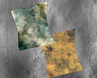
Laurel MD (SPX) Feb 21, 2007 Reaching its first 100 days of operations, the powerful mineral-detector aboard the newest satellite to circle Mars is changing the way scientists view the history of water on the red planet. The Compact Reconnaissance Imaging Spectrometer for Mars (CRISM), designed and built by the Johns Hopkins University Applied Physics Laboratory in Laurel, Md., has teamed with the five other cameras and sensors aboard NASA's Mars Reconnaissance Orbiter (MRO) to provide new clues about where water could have existed on or near the Martian surface. "We're finding that Mars has even more compositional diversity and complicated geology than had been revealed by instruments on other Mars orbiters," says Dr. Scott Murchie, CRISM principal investigator from the Applied Physics Laboratory. "With CRISM's help, this mission is going to rewrite our understanding of the planet." "CRISM's high spatial resolution provides the means to not only identify a greater range of minerals on Mars but also to associate them with small scale geologic features," says Dr. Sue Smrekar, deputy MRO project scientist at NASA's Jet Propulsion Laboratory, Pasadena, Calif. "The result is a tremendous leap forward in interpreting the geologic processes and volatile environments that created different rocks throughout the history of Mars." Since beginning its primary science phase in November 2006, the orbiter has sent home enough data to fill nearly 1,000 compact discs - quickly matching the record for Mars data returned over nine years by NASA's Mars Global Surveyor. About 30 percent of MRO's data has come from CRISM; through its telescopic scanners the instrument has taken more than 700 images of specific targets, including more than 250 at high resolution that pinpoints areas down to 15 meters - or 48 feet - in 544 "colors" of reflected sunlight. The camera has also mapped nearl y a quarter of the planet at lower resolution - showing areas as small as 200 meters (660 feet) in 72 colors - and monitored abundances of atmospheric gases and particulates in the atmosphere, returning over 500 separate measurements that track seasonal variations. "We started mapping in northern Martian summer, so we're able to compile a nearly complete map of the ices and minerals present in and around the north polar cap," says Dr. Frank Seelos, CRISM science operations lead from the Applied Physics Laboratory. Some CRISM images reveal unprecedented details of geologic processes on Mars, such as intricate compositional layering of the polar caps, and ancient rocks from Mars' earliest history that record a time when liquid water was pervasive and long-lasting. Its coverage of the north polar region is providing new insight into the vast field of gypsum-rich sand dunes that surrounds the polar cap. Over the past three months, the CRISM team has placed several of these images on the Web at CRISM's resolution in near-infrared wavelengths is about 20 times sharper than any previous look at Mars at these wavelengths. The instrument is searching for areas that were wet long enough to leave a mineral signature on the surface, looking for the spectral traces of aqueous and hydrothermal deposits, and mapping the geology, composition and stratigraphy of surface features. By identifying sites most likely to have contained water, CRISM data will help determine the best potential landing sites for future Mars missions seeking fossil traces of past life. NASA's Phoenix mission team is using data from CRISM and other high-resolution MRO instruments to support landing-site selection for its spacecraft, scheduled to touch down in the northern Martian plains in May 2008. Phoenix will determine the composition of both dry surface soil and ice-rich subsurface soil; CRISM's infrared sensitivity to the ice and salts typically found on Mars has proven valuable in helping the team find sites with ready access to both features. Email This Article
Related Links
 San Francisco (AFP) Feb 15, 2007
Growing evidence of water on Mars adds weight to the theory that life once existed and could still exist beneath its surface, said a group of scientists meeting in San Francisco. "We have abundant evidence that early Mars was water rich," Houston, Texas, Lunar and Planetary Institute astronomer Stephen Clifford told the annual meeting of the American Association for the Advancement of Science (AAAS). |
|
| The content herein, unless otherwise known to be public domain, are Copyright 1995-2006 - SpaceDaily.AFP and UPI Wire Stories are copyright Agence France-Presse and United Press International. ESA PortalReports are copyright European Space Agency. All NASA sourced material is public domain. Additionalcopyrights may apply in whole or part to other bona fide parties. Advertising does not imply endorsement,agreement or approval of any opinions, statements or information provided by SpaceDaily on any Web page published or hosted by SpaceDaily. Privacy Statement |