| . |  |
. |
Vandenberg AFB CA (SPX) Apr 27, 2007 NASA's Aeronomy of Ice in the Mesosphere (AIM) spacecraft, the first mission dedicated to the exploration of mysterious ice clouds that dot the edge of space in Earth's polar regions, successfully launched from Vandenberg Air Force Base, Calif., at 1:26 p.m. PDT on Wednesday, April 25. The mission will study clouds that are noctilucent, meaning they can be seen from the ground only at night, when they are illuminated by sunlight no longer visible from the Earth's surface. "The successful AIM launch initiates an exciting new era in understanding how noctilucent clouds form and why they vary," said Principal Investigator James M. Russell, III, of Hampton University in Hampton, Va. "The coordinated AIM measurements will provide the first focused and comprehensive data set needed to unravel the mysteries of these clouds." Noctilucent clouds are increasing in number, becoming brighter and are occurring at lower latitudes than ever before. "Such variations suggest a connection with global change," said Russell. "If true, it means that human influences are affecting the entire atmosphere, not just the region near the Earth's surface." The Stargazer L-1011 aircraft released a Pegasus XL rocket at a drop point over the Pacific Ocean, 100 miles offshore west-southwest of Point Sur, Calif. AIM was launched at an azimuth of 192.5 degrees into a circular polar orbit of 375 miles with an inclination of 97.7 degrees. At approximately 1:36 p.m., communications from a Tracking Data and Relay Satellite confirmed spacecraft separation, and the solar arrays deployed autonomously soon thereafter. The spacecraft was declared operating nominally at approximately 2:44 p.m., when it passed over the Svalbard, Norway, ground station. Spacecraft bus commissioning activities will be performed during the next six days while controllers verify satisfactory performance of all spacecraft subsystems. Throughout a 30-day check-out period, all the spacecraft subsystems and instruments will be evaluated and compared to their performance during ground testing to ensure satisfactory operation in the space environment. The instruments will maintain their protective covers to shield the near pristine optical surfaces from contamination while the spacecraft outgases volatile materials. Fourteen days after launch, the optical covers will be removed in sequence by ground commands, and the instruments will begin scientific operations. During the next two years, AIM scientists will methodically address each of six fundamental objectives that will provide critical information needed to understand cloud formation and behavior. "This mission has many firsts, including that Hampton University is the first historically black college and university to have the principle investigator and total mission responsibility for a NASA satellite mission," said Program Executive Victoria Elsbernd, NASA Headquarters, Washington. NASA's Kennedy Space Center, Fla., is responsible for launch vehicle/spacecraft integration and launch countdown management. NASA's Goddard Space Flight Center, Greenbelt, Md., is responsible for the overall AIM mission management in collaboration with Hampton University, the University of Colorado, Boulder, and Virginia Polytechnic Institute and State University, Blacksburg. Orbital Sciences Corporation, Dulles, Va., is responsible for providing the Pegasus XL launch service to NASA. AIM is the ninth small-class mission under NASA's Explorer Program, which provides frequent flight opportunities for world-class scientific investigations from space within the heliophysics and astrophysics science areas.
earlier related report The powered flight sequence for the AIM mission took just over 10 minutes, from the time the Pegasus rocket was released from its L-1011 carrier aircraft at approximately 1:26 p.m. PDT to the time that the satellite was deployed into orbit. The AIM mission was the 38th launch of the Pegasus rocket since its debut in 1990 and its 24th consecutive successful mission since 1997. Orbital also noted that yesterday's successful Pegasus launch from VAFB on the U.S. West Coast came just one day after its Minotaur space launch vehicle team successfully launched the U.S. Missile Defense Agency's NFIRE satellite from NASA's Wallops Flight Facility, on the East Coast. The successful launch of NFIRE was the seventh flight of the Minotaur I rocket, all of which have been successful. Pegasus is the world's leading launch system for the deployment of small satellites into low-Earth orbit. Its patented air-launch system, in which the rocket is launched from beneath Orbital's "Stargazer" L-1011 carrier aircraft over the ocean, reduces cost and provides customers with unparalleled flexibility to operate from virtually anywhere on Earth with minimal ground support requirements. Email This Article
Related Links
 Montreux, Switzerland (SPX) Apr 24, 2007
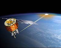
More than 900 scientists from around the world have gathered in Montreux, Switzerland, for a five-day symposium to discuss, present and review their findings on the state of our world's land, oceans, ice and atmosphere using data from ESA Earth observation satellites, in particular Envisat - the largest environmental satellite ever built. |
|
| The content herein, unless otherwise known to be public domain, are Copyright 1995-2006 - SpaceDaily.AFP and UPI Wire Stories are copyright Agence France-Presse and United Press International. ESA PortalReports are copyright European Space Agency. All NASA sourced material is public domain. Additionalcopyrights may apply in whole or part to other bona fide parties. Advertising does not imply endorsement,agreement or approval of any opinions, statements or information provided by SpaceDaily on any Web page published or hosted by SpaceDaily. Privacy Statement |