| . |  |
. |
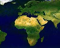
Frascati, Italy (ESA) Oct 04, 2005 Two satellite sensors work better than one for the study of Earth's oceans, atmosphere and land - that was the message of a major ESA workshop bringing together scientific users of Envisat's MERIS and AATSR instruments. Launched three and a half years ago, ESA's Envisat satellite was built with a synergistic approach in mind. Its ten onboard instruments observe the Earth in a variety of ways, but Envisat's two most closely aligned sensors are the Medium Resolution Imaging Spectrometer (MERIS) and Advanced Along-Track Scanning Radiometer (AATSR). Both instruments produce visible-light images of the Earth. MERIS acquires imagery in multispectral bands that return additional environmental information, while AATSR is a radiometer that takes the temperature of the ocean and land to a very high precision, with a dual view design to better characterise the contents of the atmosphere. Their complementary nature means there is a lot of potential in synergistic combination of their data � a possibility explored at this week's event. More than 220 European and world scientists gathered at ESRIN, ESA's European Centre for Earth Observation in Frascati, Italy, to participate in the five-day MERIS/AATSR Workshop. A total of 90 scientific presentations were given during the event, along with 14 keynote speeches, and 65 posters detailing research were on show. The Workshop also hosted training sessions in utilising the software tools used to process images from both sensors - known as the Basic ERS & Envisat AATSR and MERIS (BEAM) toolbox. Both MERIS and AATSR have a similar history: they were originally designed for operation over the ocean but their high performance has led to an increasing amount of applications for the study of atmospheric constituents and land surfaces. MERIS was optimised for the observation of ocean colour � used to derive marine phytoplankton and water contents - while AATSR's main task is to maintain a long-term record of sea surface temperature (SST) commenced by predecessor sensors (ATSR-1 and -2) from 1991 onwards. The Workshop heard that both MERIS and AATSR are still functioning nominally and are projected to continue working well for another five years. For both sensors, calibration and validation is continuing on an ongoing basis and new processing algorithms and products are being developed. Professor David Llewellyn-Jones of the Space Research Centre of the University of Leicester - whose work led to the (A)ATSR series - reviewed the prospects for synergy with MERIS: "We are at a stage now where we have enough of an understanding of our own problems that we can perhaps look outwards to where we can best combine data from the two sensors." In processing terms, AATSR's dual view was judged useful as a means of improved correction for atmospheric or aerosol effects of MERIS data. Conversely, for example, MERIS Full Resolution imagery - with a resolution three times sharper than AATSR - has the potential to better differentiate between pixels of cloud and cold ocean, which currently reduces SST coverage. There was also a lot of scientific potential for this combination of data.
Ocean AATSR records sea surface temperature with an accuracy of less than 0.3 K, and Prof. Llewellyn-Jones emphasised the value of the satellite sensor's long and independently-recorded dataset for the study of climate change. SST is also an important variable for phytoplankton distribution, as blooms are influenced by their local environment. Phytoplankton charts produced by MERIS exhibit similar patterns to SST maps; picking out currents and eddies such as the Gulf Stream and the Kuroshio Current in Asia. Improved knowledge of patterns of SST and phytoplankton correspondence could help predict blooms on regional and ultimately global levels � phytoplankton populations also being important in climate terms as marine sinks of carbon dioxide. Ana Silio of the Laboratoire d�Oc�anographie de Villefranche presented research on the Benguela Current off Africa's west coast using MERIS and AATSR in combination (together with another ocean ocean sensor SeaWIFS) to model its 'primary productivity' � the amount of biomass produced via photosynthesis. MERIS is used operationally for phytoplankton monitoring in a number of regions: a presentation on Harmful Algae Bloom (HAB) detection carried out by the Nansen Environmental and Remote Sensing Center in Norwegian coastal waters recounted that MERIS has now become the primary ocean colour instrument used for this purpose. MERIS data are also being used operationally to derive the quality of coastal water masses as part of the European Union's Framework Water Directive. The Workshop also heard how AATSR data was being assimilated in near-real time together with other SST satellite sensors and information sources for the Medspiration project, an ESA-funded effort to represent the temperatures of the seas around Europe as the continent's contribution to a worldwide project to do the same on a global basis � the Global High Resolution Sea Surface Temperature Pilot Project (GHRSST-PP).
Atmosphere Both sensors are currently the source of a number of atmospheric products: AATSR returns information on cloud properties including aerosol size and optical thickness and depth while MERIS also returns information on the aerosol distribution as well as atmospheric water vapour concentration detection. Combining atmospheric information from both could be useful for atmospheric correction and improving overall data quality. One presentation by Hermann Mannstein of the German Aerospace Center (DLR) recounted how AATSR is being used to detect the straight clouds from aircraft exhausts over Europe and the North Atlantic, as part of an ESA project called Contrails to examine their environmental impact. MERIS results were being used to validate the AATSR-based algorithm used to spot contrails.
Land MERIS's multispectral capability makes it highly adaptable for land cover mapping. A number of MERIS processing algorithms were discussed during the Workshop, including one algorithm developed by the European Commission's Joint Research Centre (EC-JRC) used to monitor photosynthesis activity, and so track plant growth and health across Europe and the world. Jadunandan Dash of Southampton University discussed another MERIS product, the MERIS Terrestrial Chlorophyll Index (MTCI) and its use to identify levels of chlorophyll in forests. MTCI has also shown a chlorophyll reduction on vegetation in low-lying coastal zones affected by the tsunami of 26 December 2004. The reduction is due to salt stress, and the plan is to monitor other affected areas to see how the vegetation recovers. The Workshop also heard presentations on how MERIS Full Resolution mode, with its 300 metre resolution, is being utilised for ESA's GLOBCOVER project, which is planned to provide the world's sharpest land cover map. On land AATSR has been used to maintain a long-term ATSR Fire Atlas, working by night to identify hot spots of fires. One presentation subject was the comparison of ATSR Fire Atlas and MERIS-derived land classifications. A new AATSR Land Surface Temperature (LST) extends the sensor's applications on land, with a maximum accuracy by night of a few degrees K.
The future As well as presenting results, the Workshop was also an opportunity for the MERIS and AATSR communities to exchange information with each other and give their inputs to ESA. Overall the scientists pronounced themselves satisfied with data delivery, particularly MERIS Reduced Resolution data, which is now made available via a rolling internet-based archive. Also MERIS Full Resolution data are now being systematically acquired over land and coastal areas and, in turn, being systematically processed, with the long term intention of being similarly made accessible online. The main area of concern was the issue of data continuity: any interruption in the (A)ATSR data archive, which will stretch across almost two decades by the time Envisat retires, would be scientifically damaging. The need to continue the availability of MERIS data was also stressed. The current ESA plan is for a satellite for oceanography and land surface monitoring to continue MERIS and AATSR-type observations, either within a combined instrument or as separate sensors. This mission forms part of the Earth Watch line of missions within ESA's Living Planet programme, intended to address the sustained observational requirements of the ESA/EU Global Monitoring for Environment and Security (GMES) programme. GMES is a joint initiative of ESA and the European Union to develop independent access to environmental information services in support of European policy goals. ESA's Ministerial Conference in December 2005 is due to consider a mission known as GMES-1 to ensure data continuity beyond Envisat. Related Links ERS overview GLOBCOVER SpaceDaily Search SpaceDaily Subscribe To SpaceDaily Express
Do giant flashes of lightning striking upwards from thunder clouds merely pose an extraordinarily spectacular view? Or do they actually alter the chemical composition of the atmosphere, playing a role in ozone depletion and the climate on Earth? |
|
| The content herein, unless otherwise known to be public domain, are Copyright 1995-2006 - SpaceDaily.AFP and UPI Wire Stories are copyright Agence France-Presse and United Press International. ESA PortalReports are copyright European Space Agency. All NASA sourced material is public domain. Additionalcopyrights may apply in whole or part to other bona fide parties. Advertising does not imply endorsement,agreement or approval of any opinions, statements or information provided by SpaceDaily on any Web page published or hosted by SpaceDaily. Privacy Statement |