| . |  |
. |
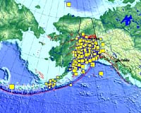
Tacoma WA (SPX) Nov 27, 2007 Earth tremors not linked to volcanic activity first turned up in seismic observations several years ago, but those tremors were almost exclusively in subduction zones such as the Cascadia region off the coast of the Pacific Northwest. New research has found evidence of tremors along non-subduction zone faults in seven California locations. The tremors immediately followed the magnitude 7.8 Denali earthquake in Alaska on Nov. 3, 2002 and are linked to that quake even though they are as much as 2,400 miles from its epicenter. "This suggests there is a much greater variety of ways that faults store up stress and release it," said Joan Gomberg, an affiliate professor of Earth and space sciences at the University of Washington and a research scientist with the U.S. Geological Survey in Seattle. The tremors began within an hour of the Denali earthquake, and their signal was observed as high-frequency pulses among the lower-frequency signals from the main earthquake. The seven distinct areas, stretching from north of San Francisco to southeast of Los Angeles, are near Napa Valley, San Jose, San Juan Bautista, Simi Valley, Hemet and two sites near Parkfield. Five of the sources are close to or on dominant strike-slip faults - the San Andreas, San Jacinto and Calaveras faults - in which two blocks of the Earth's crust slide past each other horizontally. The scientists believe the other two tremor sources, in Napa Valley and Simi Valley, are likely on more minor faults. "All seven of these were set off by the strong passing waves from Denali," Gomberg said. The research is being published Nov. 22 in Science Express, the online edition of the journal Science. Co-authors are Justin Rubinstein, Kenneth Creager, John Vidale and Paul Bodin of the UW and Zhigang Peng of the Georgia Institute of Technology. Tremor episodes have been observed near volcanoes for many years, and more recently they have been seen around subduction zones such as Cascadia, regions where the Earth's tectonic plates are shifting so that one slides beneath another. Tremors in subduction zones are associated with slow-slip events in which energy equivalent to a moderate-sized earthquake is released over days or weeks, rather than seconds. The scientists examined all available recordings of Denali earthquake waves from seismic stations throughout California and were able to identify high-frequency waves that pulsed with passing surface waves. The researchers determined the high-frequency waves were not part of the Denali quake itself, nor were they caused by any smaller nearby earthquakes. Previous studies have indicated a possible link between tremor or slow-slip events and fluids and high temperatures within tectonic plates. So the scientists specifically examined data from stations close to two geothermal fields in California, but they found no apparent signal for tremor. "It was the opposite of what we expected," Gomberg said. The lack of tremor in these areas triggered by the Denali earthquake probably means that while fluids or high temperatures might be necessary for a tremor, they are not sufficient by themselves to produce tremor, the scientists concluded. Gomberg said it is possible that tremor events occur at the edges of zones where two tectonic plates are locked together, gradually building energy toward a major earthquake. If that is the case, she said, the research could help scientists map the locked zones and develop a clearer picture of a particular region's earthquake risk. "This has opened new questions, and perhaps it has provided the start of some answers, about what makes faults move and the ways that they move," Gomberg said. "Such research has made it worth it to put in all the recording equipment that we have measuring seismic events. You never know what you are going to learn." Community Email This Article Comment On This Article Related Links University of Washington Tectonic Science and News
 Tacoma WA (SPX) Nov 26, 2007
For more than a decade geoscientists have detected what amount to ultra-slow-motion earthquakes under Western Washington and British Columbia on a regular basis, about every 14 months. Such episodic tremor-and-slip events typically last two to three weeks and can release as much energy as a large earthquake, though they are not felt and cause no damage. Now University of Washington researchers have found evidence that these slow-slip events are actually affected by the rise and fall of ocean tides. |
|
| The content herein, unless otherwise known to be public domain, are Copyright 1995-2007 - SpaceDaily.AFP and UPI Wire Stories are copyright Agence France-Presse and United Press International. ESA Portal Reports are copyright European Space Agency. All NASA sourced material is public domain. Additional copyrights may apply in whole or part to other bona fide parties. Advertising does not imply endorsement,agreement or approval of any opinions, statements or information provided by SpaceDaily on any Web page published or hosted by SpaceDaily. Privacy Statement |