| . |  |
. |
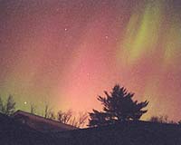
When it comes to space weather, it's not just about whether it's raining or cloudy. Not even close. "Space weather affects radio communications and navigation systems such as the Global Positioning System (GPS) so it's not necessarily a case of what you see is what you get," said Richard Langley, a geodesy and geomatics engineering professor at the University of New Brunswick in Fredericton, Canada. "Space weather includes a variety of phenomena taking place in the Earth's upper atmosphere. Conditions on the sun and in the solar wind, the magnetosphere and the ionosphere can affect our daily lives through the effects they have on satellites, communications, navigation and power systems." With that in mind, Dr. Langley and Hyunho Rho, a PhD candidate in UNBF's GGE department, have developed a new technique for studying space weather using GPS. By analyzing the signals from GPS satellites which travel through the ionosphere on their way to a network of Earth-bound receivers, UNBF's researchers are examining the effects of non-linear spatial variations in the distributions of the ionosphere's free electrons and how those distributions are affected by geomagnetic storms. In order to better estimate the ionospheric parameters which depend on the latitude and longitude variations at a specific height above the Earth, Dr. Langley and Mr. Rho use a second-order model which is a more comprehensive and complicated model than the more conventional linear model. "The way the world works is inherently non-linear," said Dr. Langley. "As a first approximation, researchers typically assume linear behaviour when trying to model a particular phenomenon; a more accurate description is obtained by accounting for non-linearity." There were some obstacles along the way. "One of the most difficult tasks we faced in this research was determining how many stations or how much data we could use," said Mr. Rho. "Increasing the number of stations improves the fidelity of the ionospheric model but places higher demands on the computing facility to provide results in a timely manner." The advanced model requires significant computational power, especially when more and more GPS stations providing more data are used to determine the parameters at each epoch. Mr. Rho programmed the model to run on the new Sun Microsystems V60 computer cluster at UNBF's Advanced Computational Research Laboratory (ACRL). The ACRL is the most powerful publicly accessible high-performance computing facility in Atlantic Canada. "With ARCL's infrastructure and the help provided by its personnel, we could use more data to better explain the variations of the ionosphere with a significant savings in processing time," said Mr. Rho. "We believe this facility could serve other researchers who need to process large datasets with sophisticated models. That's something which could not be done efficiently with standard computing tools." Mr. Rho presented the initial results from the new model last fall at the 17th annual international technical meeting of the satellite division of The Institute of Navigation in Long Beach, CA. His work sparked interest from scientists and engineers from around the world. It appears the results could serve as a baseline for further improvements in the ionospheric modeling techniques required for satellite-based augmentations to GPS. That would include the Wide Area Augmentation System and the Canada-wide Differential GPS Service. Related Links SpaceDaily Search SpaceDaily Subscribe To SpaceDaily Express 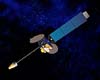 El Segundo CA (SPX) Mar 30, 2005
Raytheon's Japanese Advanced Meteorological Imager has been successfully launched on board Japan's Multi-functional Transport Satellite-1 Replacement (MTSAT-1R), built by prime contractor, Space Systems/Loral (SS/L), and is now providing new images of earth.
|
| ||||||||||
| The content herein, unless otherwise known to be public domain, are Copyright 1995-2016 - Space Media Network. All websites are published in Australia and are solely subject to Australian law and governed by Fair Use principals for news reporting and research purposes. AFP, UPI and IANS news wire stories are copyright Agence France-Presse, United Press International and Indo-Asia News Service. ESA news reports are copyright European Space Agency. All NASA sourced material is public domain. Additional copyrights may apply in whole or part to other bona fide parties. Advertising does not imply endorsement, agreement or approval of any opinions, statements or information provided by Space Media Network on any Web page published or hosted by Space Media Network. Privacy Statement All images and articles appearing on Space Media Network have been edited or digitally altered in some way. Any requests to remove copyright material will be acted upon in a timely and appropriate manner. Any attempt to extort money from Space Media Network will be ignored and reported to Australian Law Enforcement Agencies as a potential case of financial fraud involving the use of a telephonic carriage device or postal service. |