| . |  |
. |
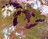
The image is from NOAA-17, which was launched on June 24 from Vandenberg Air Force Base, Calif., and named NOAA-M before launch. The image shows cloud patterns over the Great Lakes area. Like other NOAA satellites, NOAA-17 will collect meteorological data and transmit the information to users around the world to enhance weather forecasting. In the United States, the data will be used primarily by NOAA's National Weather Service for its long-range weather and climate forecasts. NOAA-17 was built by Lockheed Martin Space Systems Co., Sunnyvale, Calif., and launched for NOAA under technical guidance and project management by NASA's Goddard Space Flight Center. NASA will turn operational control of the NOAA-17 spacecraft over to NOAA 21 days after launch. NASA's comprehensive on-orbit verification period is expected to last until approximately 45 days after launch. Related Links NOAA SpaceDaily Search SpaceDaily Subscribe To SpaceDaily Express 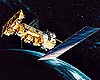 Sunnyvale - June 17, 2002
The NOAA-M spacecraft, a polar-orbiting operational earth observation satellite, is set to launched from Vandenberg Air Force Base, Calif. on June 24, 2002 at 5:22pm PST (1822 GMT). Lockheed Martin Space Systems built the NOAA-M satellite, and a Titan 2 rocket, provided under contract to the U.S. Air Force will carry the satellite into orbit.
|
| ||||||||||
| The content herein, unless otherwise known to be public domain, are Copyright 1995-2016 - Space Media Network. All websites are published in Australia and are solely subject to Australian law and governed by Fair Use principals for news reporting and research purposes. AFP, UPI and IANS news wire stories are copyright Agence France-Presse, United Press International and Indo-Asia News Service. ESA news reports are copyright European Space Agency. All NASA sourced material is public domain. Additional copyrights may apply in whole or part to other bona fide parties. Advertising does not imply endorsement, agreement or approval of any opinions, statements or information provided by Space Media Network on any Web page published or hosted by Space Media Network. Privacy Statement All images and articles appearing on Space Media Network have been edited or digitally altered in some way. Any requests to remove copyright material will be acted upon in a timely and appropriate manner. Any attempt to extort money from Space Media Network will be ignored and reported to Australian Law Enforcement Agencies as a potential case of financial fraud involving the use of a telephonic carriage device or postal service. |