| . |  |
. |
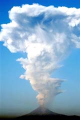
Popocatepetl, a volcano one hour southeast of Mexico's capital, kept up its pattern of erupting every December for ten years, when it spit a plume of ash into the sky on Thursday. "An explosion occurred at 6:53 this morning (1253 GMT)," said Ramon Pena, director of a government agency that monitors the volcano, Popocatepetl Operating Plan. The plume of ash shot five kilometers (three miles) into the sky, raining ash on villages north of the volcano. No alert was sounded, however. The volcano is 60 kilometers (37 miles) outside Mexico City. The army is permanently stationed there and the public is barred within 12 kilometers (seven miles) of the crater. The volcano has been increasingly active in the month of December over the last ten years. At 5,452 meters (17,887 feet) Popocatepetl, or "Don Goyo" as it is popularly known in Mexico, straddles the states of Mexico, Pueblo and Morelos in central Mexico. It first erupted 23,000 years ago. All rights reserved. � 2005 Agence France-Presse. Sections of the information displayed on this page (dispatches, photographs, logos) are protected by intellectual property rights owned by Agence France-Presse. As a consequence, you may not copy, reproduce, modify, transmit, publish, display or in any way commercially exploit any of the content of this section without the prior written consent of Agence France-Presse. Related Links SpaceDaily Search SpaceDaily Subscribe To SpaceDaily Express  Kingston, RI (SPX) Nov 24, 2005
Two University of Rhode Island researchers have been awarded an $86,000 grant from FM Global to create maps of the East Coast of the U.S. that will identify potential flooding and damage that could occur if a tsunami struck the region.
|
| ||||||||||
| The content herein, unless otherwise known to be public domain, are Copyright 1995-2016 - Space Media Network. All websites are published in Australia and are solely subject to Australian law and governed by Fair Use principals for news reporting and research purposes. AFP, UPI and IANS news wire stories are copyright Agence France-Presse, United Press International and Indo-Asia News Service. ESA news reports are copyright European Space Agency. All NASA sourced material is public domain. Additional copyrights may apply in whole or part to other bona fide parties. Advertising does not imply endorsement, agreement or approval of any opinions, statements or information provided by Space Media Network on any Web page published or hosted by Space Media Network. Privacy Statement All images and articles appearing on Space Media Network have been edited or digitally altered in some way. Any requests to remove copyright material will be acted upon in a timely and appropriate manner. Any attempt to extort money from Space Media Network will be ignored and reported to Australian Law Enforcement Agencies as a potential case of financial fraud involving the use of a telephonic carriage device or postal service. |