| . |  |
. |
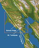
Earthquakes are not unusual in the San Francisco Bay Area, but a team of Penn State geoscientists believes that the hazard may be greater than previously thought because of a hidden fault under Marin County. "We think we have evidence that there is an additional earthquake hazard in the San Francisco area due to a blind thrust fault," says Dr. Kevin P. Furlong, professor of geosciences. "Blind thrust faults are notorious because they are hard to find until an earthquake occurs on them. A blind thrust fault caused the 1994 Northridge earthquake." The San Francisco Bay Area has a variety of known faults running through it. The San Andreas fault runs on the west, while the Hayward fault is on the east and shifts into the Rodgers Creek fault northeast of the city. The San Gregorio fault, west of the San Andreas, meets that fault near the Golden Gate Bridge. The slip rate on the Hayward fault is about 9 millimeters a year and the slip on the Rodgers Creek fault is probably 6 to 9 millimeters a year, according to Furlong. These two rates are consistent. However, the slip on the San Andreas fault south of the Golden Gate Bridge is 17 millimeters per year and the slip rate north of the bridge is 24 millimeters per year. Adding in the San Gregorio fault slip of about 3 millimeters a year, the slip rate on the northern San Andreas is still inconsistent with the southern portion of the fault by as much as 4 millimeters per year. Compounding the geological confusion is the existence of Mt. Tamalpais at 2,640 feet sitting northeast of San Francisco in Marin County. Geologists are unsure why Mt. Tamalpais is there and what formed it. Furlong and Dr. Eric Kirby, assistant professor of geosciences, looked for an explanation for the different slip rates on the San Andreas fault north and south of the Golden Gate that would also explain how Mt Tamalpais came to rise above the bay. "In the past, the thought was that there must be something wrong with the calculations on the San Gregorio fault," says Furlong. "That is, the slip rate must be closer to 7 millimeters per year because we do not see any other faults." The researchers hypothesized that a fault running diagonally from the northern Hayward fault to the San Andreas in Marin County could transfer the necessary motion to the San Andreas and might explain high topography around Mt Tamalpais. However, proving the fault's existence turns out to be a difficult task. Thrust faults occur when one piece of terrain rides up over another forming a characteristic uplift pattern with one side gradually sloping up and the other more precipitous. Blind thrust faults terminate below the Earth's surface and are therefore blind. "We asked, can we demonstrate that Mt Tamalpais is currently going up, thrusting?" said Furlong. "Uplift rates are just at the limit of what can be measured with geographic positioning systems and there are not sufficient prior measurements on the mountain to compare with anyway," he told attendees at the fall conference of the American Geophysical Union in San Francisco. Estimating that the uplift is about 1 millimeter per year � less than normally observable with GPS, the researchers looked for another way to measure uplift. They considered the topography of Marin County. Bolinas Ridge � just east of Point Reyes � runs up the west side of the area just to the west of Mt. Tamalpais and has a gradually rising slope, similar to the uplift predicted by a blind fault. It also has numerous streams running off the ridge peak into the San Andreas fault. "If an area is uplifting, then we typically see steep rivers, but if the uplift is slow or nonexistent, then we see gentle rivers," says Furlong. "What we find is that the rivers become substantially steeper in the southern portion of Bolinas Ridge, implying that there may be active uplift in the area." The rock making up Bolinas Ridge is of uniform composition, so differences in river slopes probably reflect differences in erosion rate. Assuming there is a blind thrust fault, the slip rate on the fault would need to be 3 to 4 millimeters to even out the discrepancies north and south of the Golden Gate Bridge. If the slip is 3 to 4 millimeters, then the researchers calculate that there would be potential for an earthquake of magnitude 6 to 6.5 on the fault occurring on a time scale of several hundred years. Courtney B. Johnson, graduate student in Penn State's department of geosciences, is presenting a poster that further explores the size and earthquake potential of the blind thrust fault. "No large earthquakes have occurred in that area for at least the 150 to 200 years we have records," says Furlong. "In fact, there are very few earthquakes of any size in this general area." The researchers are planning research to prove that the blind thrust fault exists. Unfortunately, standard seismic imaging will not work on the type of rock in the area, so alternative methods are necessary. "The Loma Prieta earthquake did a lot of damage to the East Bay and Marina areas of San Francisco," says Furlong. "An earthquake in Marin County, while smaller, is much closer and is of concern not only to those in the county, but also to that part of San Francisco." Related Links Penn State SpaceDaily Search SpaceDaily Subscribe To SpaceDaily Express  Berkeley CA (SPX) Dec 10, 2004
University of California, Berkeley, seismologists have discovered mysterious tremors deep under the San Andreas Fault that may portend future earthquakes.
|
| ||||||||||
| The content herein, unless otherwise known to be public domain, are Copyright 1995-2016 - Space Media Network. All websites are published in Australia and are solely subject to Australian law and governed by Fair Use principals for news reporting and research purposes. AFP, UPI and IANS news wire stories are copyright Agence France-Presse, United Press International and Indo-Asia News Service. ESA news reports are copyright European Space Agency. All NASA sourced material is public domain. Additional copyrights may apply in whole or part to other bona fide parties. Advertising does not imply endorsement, agreement or approval of any opinions, statements or information provided by Space Media Network on any Web page published or hosted by Space Media Network. Privacy Statement All images and articles appearing on Space Media Network have been edited or digitally altered in some way. Any requests to remove copyright material will be acted upon in a timely and appropriate manner. Any attempt to extort money from Space Media Network will be ignored and reported to Australian Law Enforcement Agencies as a potential case of financial fraud involving the use of a telephonic carriage device or postal service. |