| . |  |
. |
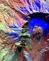
NASA scientists took infrared (IR) digital images of Mount Saint Helens last week. The images revealed signs of heat below the surface one day before the volcano erupted last Friday in southern Washington. The images may provide valuable clues as to how the volcano erupted. Scientists flew an IR imaging system aboard a small Cessna Caravan aircraft over the mountain to acquire the data. "Based on the IR signal, the team predicted an imminent eruption," said Steve Hipskind, acting chief of the Earth Science Division at NASA Ames Research Center, located in California's Silicon Valley. "We were seeing some thermal artifacts in the floor of the Mount Saint Helens crater in southern Washington," said Bruce Coffland, a member of the Airborne Sensor Facility at NASA Ames. "We flew Thursday and used the 50-channel MODIS/ASTER Airborne Simulator (MASTER) digital imaging system. We are working to create images from the IR data that depict the thermal signatures on the dome," Coffland added. MASTER is an airborne simulator instrument similar to the Advanced Spaceborne Thermal Emission and Reflection Radiometer (ASTER) high-resolution infrared imager carried on NASA's Terra Earth observation satellite. Scientists plan to fly the MASTER instrument again over the volcano early this week. The NASA Ames airborne sensor team was in the area taking data for a United States Geological Survey (USGS) study examining some of the effects of the 1980 Mount Saint Helens eruption. "This had been planned for some time, and we were there totally by coincidence," Coffland said. The science objectives for the USGS study were to outline the boundaries of the lava flows associated with Mount Saint Helens' previous eruptions in 1980. "We flew four flight lines over the mountain," Coffland said. "It's a continuous scan image, eight miles long (13 kilometers) and about 2.3 miles (3.7 kilometers) wide." There were four adjoining flight lines flown for Joel Robinson, an investigator at USGS, Menlo Park, Calif. After the plane landed, technicians downloaded data from a computer hard drive, and began to process the data to produce an image format for use by scientists. NASA will post the pre and post eruption infrared images on the Web. Sky Research, based in Ashland, Ore., provided the Cessna Caravan, a propeller driven, single-engine airplane that carried the IR imager. Related Links SpaceDaily Search SpaceDaily Subscribe To SpaceDaily Express 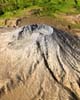 Pasadene CA (JPL) Oct 04, 2004
Mount Saint Helens is a prime example of how Earth's topographic form can greatly change even within our lifetimes. The mountain is one of several prominent volcanoes of the Cascade Range that stretches from British Columbia, Canada, southward through Washington, Oregon, and into northern California.
|
| ||||||||||
| The content herein, unless otherwise known to be public domain, are Copyright 1995-2016 - Space Media Network. All websites are published in Australia and are solely subject to Australian law and governed by Fair Use principals for news reporting and research purposes. AFP, UPI and IANS news wire stories are copyright Agence France-Presse, United Press International and Indo-Asia News Service. ESA news reports are copyright European Space Agency. All NASA sourced material is public domain. Additional copyrights may apply in whole or part to other bona fide parties. Advertising does not imply endorsement, agreement or approval of any opinions, statements or information provided by Space Media Network on any Web page published or hosted by Space Media Network. Privacy Statement All images and articles appearing on Space Media Network have been edited or digitally altered in some way. Any requests to remove copyright material will be acted upon in a timely and appropriate manner. Any attempt to extort money from Space Media Network will be ignored and reported to Australian Law Enforcement Agencies as a potential case of financial fraud involving the use of a telephonic carriage device or postal service. |