| . |  |
. |
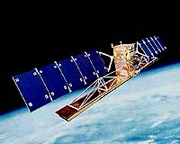
A NASA-funded study of marine pollution in Southern California concluded space-based synthetic aperture radar can be a vital observational tool for assessing and monitoring ocean hazards in urbanized coastal regions. "Clean beaches and coastal waters are integral to Southern California's economy and lifestyle," said Dr. Paul DiGiacomo, an oceanographer at NASA's Jet Propulsion Laboratory. He is lead author of the study recently published in the Marine Pollution Bulletin. "Using Southern California as a model system, we've shown existing high-resolution space-based radar systems can be used to effectively detect and assess marine pollution hazards. This is an invaluable tool for water quality managers to better protect public health and coastal resources," he said. DiGiacomo and colleagues from JPL; the University of California, Santa Barbara; and the University of Southern California, Los Angeles, examined satellite radar imagery of the coastal waters of Southern California. The area is adjacent to 20 million people, nearly 25 percent of the U.S. coastal population. The imaging radar data from the European Space Agency's European Remote Sensing Satellites 1 and 2 and Canada's RADARSAT were complemented by shore-based surface current radar data and other field measurements. "The key to evaluating and managing pollution hazards in urban coastal regions is accurate, timely data," DiGiacomo said. "Since such hazards are usually localized, dynamic and episodic, they're hard to assess using oceanographic field sampling. Space-based imaging radar works day and night, regardless of clouds, detecting pollution deposits on the sea surface. "Combined with field surveys and other observations including shore-based radar data, it greatly improves our ability to detect and monitor such hazards," he said. The study described three major pollutant sources for Southern California: storm water runoff, wastewater discharge and natural hydrocarbon seepage. "During late fall to early spring, storms contribute more than 95 percent of the region's annual runoff volume and pollutant load," said JPL co-author Ben Holt. "Californians are accustomed to warnings to stay out of the ocean during and after storms. Even small storms can impact water quality. Radar data can be especially useful for monitoring this episodic seasonal runoff," he said. DiGiacomo noted a regional Southern California marine water quality monitoring survey is under way involving JPL and more than 60 other organizations, including the Southern California Coastal Water Research Project. Its goal is to characterize the distribution and ecological effects of storm water runoff in the region. Space radar and other satellite sensor data are being combined, including NASA's Moderate Resolution Imaging Spectroradiometers. The sensors provide frequent observations, subject to clouds, of ocean color that can be used to detect regional storm water runoff and complement the finer resolution but less frequent radar imagery. The second largest source of the area's pollution is wastewater discharge. Publicly owned treatment works discharge daily more than one billion gallons of treated wastewater into Southern California's coastal waters. Even though it is discharged deep offshore, submerged plumes occasionally reach the surface and can contaminate local shorelines. Natural hydrocarbon seeps are another local pollution hazard. Underwater seeps in the Santa Barbara Channel and Santa Monica Bay have deposited tar over area beaches. Space imaging radar can track seepage on the ocean surface, as well as human-caused oil spills, which are often affected by ocean circulation patterns that make other tracking techniques difficult. Further research is necessary to determine the composition of pollution hazards detected by radar. "From imaging radar, we know where the runoff is, but not necessarily which parts of it are harmful," Holt said. "If connections can be established, imaging radar may be able to help predict the most harmful parts of the runoff." While the researchers said environmental conditions such as wind and waves can limit the ability of space radar to detect ocean pollution, they stressed the only major limitation of the technique is infrequent coverage. "Toward the goal of a comprehensive coastal ocean observing system, development of future radar missions with more frequent coverage is a high priority," DiGiacomo said. Related Links NASA SpaceDaily Search SpaceDaily Subscribe To SpaceDaily Express  Kiruna (SPX) Mar 10, 2005
The Swedish Space Corporation (SSC) has been awarded the contract to upgrade the MSS 5000 surveillance system for The Norwegian Coastal Administration (Kystverket). The system to be upgraded includes a SLAR (Side Looking Airborne Radar), an IR/UV scanner, cameras and a data link.
|
| ||||||||||
| The content herein, unless otherwise known to be public domain, are Copyright 1995-2016 - Space Media Network. All websites are published in Australia and are solely subject to Australian law and governed by Fair Use principals for news reporting and research purposes. AFP, UPI and IANS news wire stories are copyright Agence France-Presse, United Press International and Indo-Asia News Service. ESA news reports are copyright European Space Agency. All NASA sourced material is public domain. Additional copyrights may apply in whole or part to other bona fide parties. Advertising does not imply endorsement, agreement or approval of any opinions, statements or information provided by Space Media Network on any Web page published or hosted by Space Media Network. Privacy Statement All images and articles appearing on Space Media Network have been edited or digitally altered in some way. Any requests to remove copyright material will be acted upon in a timely and appropriate manner. Any attempt to extort money from Space Media Network will be ignored and reported to Australian Law Enforcement Agencies as a potential case of financial fraud involving the use of a telephonic carriage device or postal service. |