| . |  |
. |
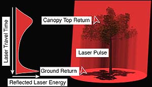
Sydney - March 30, 2000 - Airborne systems that can peer deep into forest canopies to assess their biomass, structure and condition are under development by CSIRO. The Vegetation Canopy Lidar (or light radar) is expected to revolutionise the task of measuring Australia's forest stocks, says Dr David Jupp, head of CSIRO's Office of Space Science and Applications (COSSA) and Earth Observation Centre (EOC). "These new systems will enable us to monitor re-vegetation and regrowth, assess the environmental sustainability of logging or mine rehabilitation and keep track of our forests' ability to soak up greenhouse gases," he says. Forests are central to many current environmental issues. Sustainable development, biodiversity conservation and now greenhouse gas abatement and carbon trading depend on forests. Satellite images are routinely used to map forest area. "What has been missing till now is an accurate description of what's inside the forest, the structure of the forest canopy," Dr Jupp says. CSIRO researchers have developed designs and specifications for airborne and ground based Vegetation Canopy Lidars and how to use their data in Australian conditions. They are part of an international team whose ultimate aim is to use spaceborne systems to map forests globally. EOC is coordinating this effort and is now setting out to bring it to market through commercial partnerships. "Accurate measurement and monitoring of tree cover and biomass are of vital interest to foresters, land managers and ecologists. "The trouble is that accurately assessing tree cover over huge tracts of country is currently slow, costly and difficult using present techniques. Moreover, the relationship between cover and biomass is complex," says Dr Jupp. "However, we are now well placed to carry out accurate large-scale forest surveys using a combination of airborne Lidar sensing systems, current spectral sensors, new methods of data analysis and advanced information technology. "The key to this will be getting local access to the right instruments and focussing the right talent to bring it off. "The Vegetation Canopy Lidar systems will penetrate the forest canopy and assess the size, shape and state of growth of the trees, and how their leaves and stems are arranged both horizontally or vertically in a cost-effective way. "You might say we will for the first time be able to see the whole wood for the trees," Dr Jupp says. "Using Vegetation Canopy Lidar we will soon be able to carry out forest and vegetation surveys over large areas of Australia, as well as other regions of the world." Dr Jupp says the project will also explore the rapidly developing business prospects for Australian industry to manufacture and export canopy Lidar systems to the world market or develop businesses in monitoring the forest inventory and environment. "The technology is ideal for world application. There are business opportunities in both the instrumentation and in the use of its data. We have all the components. Now it's a case of integrating them into a truly effective total system. "Australia has several very advanced laser technology companies, so we have a potential industry to build and market vegetation canopy Lidars for the world market." CSIRO is working with Leadenhall Australia Ltd, corporate advisors, to assess the potential market and identify likely collaborative partners to develop the technology. Dr Jupp says terrain Lidars have been widely used for some years to map ground elevation and features. A classic application of terrain Lidar by NASA was in the mapping of the surface of Mars. "In a terrain Lidar a strong pulse of laser light energy is sent in a narrow beam, and the time it takes to bounce back gives you the range to the surface. The narrow beam is designed to pass through as many gaps in the land cover (such as the vegetation) as possible. Using a high density of these pulses enables you to map hills and valleys and even small variations in elevation with great precision. "On the other hand, in a vegetation canopy Lidar, the laser pulse is spread into a wider spot and information is scanned over a relatively wide area. Multiple returns from each pulse are recorded at a very high rate to build up a picture of the vertical profile and condition of the whole forest canopy as well as the topography. "We use advanced software to convert these return signals into vertical and horizontal canopy information, to create a sort of 3-dimensional map of the canopy. By combining data from a number of sources, we can make estimates of forest biomass," Dr Jupp says. "This will be invaluable for foresters, land managers, ecologists and those with an interest in taking account of the forest and the trees across Australia, and around the world."
RADAR TRACKS AT SPACEDAILY
|
| ||||||||||
| The content herein, unless otherwise known to be public domain, are Copyright 1995-2016 - Space Media Network. All websites are published in Australia and are solely subject to Australian law and governed by Fair Use principals for news reporting and research purposes. AFP, UPI and IANS news wire stories are copyright Agence France-Presse, United Press International and Indo-Asia News Service. ESA news reports are copyright European Space Agency. All NASA sourced material is public domain. Additional copyrights may apply in whole or part to other bona fide parties. Advertising does not imply endorsement, agreement or approval of any opinions, statements or information provided by Space Media Network on any Web page published or hosted by Space Media Network. Privacy Statement All images and articles appearing on Space Media Network have been edited or digitally altered in some way. Any requests to remove copyright material will be acted upon in a timely and appropriate manner. Any attempt to extort money from Space Media Network will be ignored and reported to Australian Law Enforcement Agencies as a potential case of financial fraud involving the use of a telephonic carriage device or postal service. |
 Albuquerque - September 1, 1999 - Lynx, a new fine resolution, real time synthetic-aperture radar (SAR) system, was unveiled here Saturday, Aug. 28 by the Department of Energy's Sandia National Laboratories and General Atomics of San Diego.