| . |  |
. |
Hopes that the El Nino weather phenomenon will come riding out of the west and save the nation from more deadly hurricanes this year may be premature, forecasters say. The Pacific Ocean temperatures put us on the borderline of an El Nino event right now, said David Zierden, an assistant Florida state climatologist. He is also a member of the Southeastern Climate Consortium, an organization of professors dedicated to predicting seasonal climate conditions. Based on the storm activity we're seeing in the Atlantic, I'm not sure this will come on strong enough to affect the hurricane season, said Zierden. El Nino occurs every two to seven years when winds in the tropical Pacific that normally blow east to west over the equator ease or reverse, causing warming of surface waters in the eastern Pacific. The phenomenon upsets normal weather patterns worldwide, spurring warmer, wetter winters in the Americas, droughts in parts of Africa and Asia and other climatic anomalies. Its counterpart, La Niña, follows an El Nino event and has the opposite effect, leading, for example, to drier weather on the west coast of the Americas. The National Oceanic and Atmospheric Administration reported this month that El Nino will be back and is expected to last through early 2005. The events, however, can last up to 12 to 18 months. NOAA also said it was not clear what impact the event would have on the weather. Meteorologist Jim Lushine of the National Weather Service in Miami told the South Florida Sun-Sentinel he doesn't expect El Nino to produce an early end to the flurry of hurricanes this year, or to make them less intense. There's not an instant reaction to El Nino on the hurricane season, he said. But he did say it could be fully in place for the 2005 hurricane season. Next season could be quieter. We could use some quiet, he said. Indeed we could. Florida is suffering through its worse hurricane season in decades. The trouble started Aug. 13 when Charley hit Punta Gorda as a Category 4 hurricane. Then came Hurricane Frances, which hit Stuart, Fla., Sept. 12 as a Category 3 hurricane on the Saffir-Simpson scale of 1 to 5. Ivan arrived Thursday at Gulf Shores, Ala., causing heavy damage. It continued north, causing disastrous flooding as far north as Ohio. Damage estimates from Ivan range from $2 billion to $10 billion and could go higher. Charley and Frances caused at estimated $11 billion in combined insured losses, and when you factor in other losses such as public infrastructure and tourism the figure goes way up. Charley and Frances also are responsible for taking 46 lives in this country, and the unofficial toll for Ivan alone is 50. Getting a final total on the fatalities this hurricane season is going to be iffy at best because so many of them are in the Third World nations of the Caribbean, where counting is difficult. In Haiti, for instance, Jeanne took an estimated 700 lives in northern sections. And Jeanne is not done. Hurricane Jeanne was headed south in the Atlantic with 100 mph winds Wednesday and eventually could turn west in the direction of the U.S. mainland, forecasters said. An advisory by the National Hurricane Center in Miami said Jeanne could turn northwest by Saturday and move north later in the weekend. That could put the North Carolina coast in jeopardy. At 11 a.m. forecasters said Jeanne was located at latitude 26.3 north, longitude 68.5 west or about 530 miles east of Great Abaco Island in the Bahamas. Two other storms posed no immediate threat to land. Hurricane Karl was located about 1,490 miles west-southwest of the Azores. It was moving north at 14 mph with top winds of 105 mph. Tropical storm Lisa carried winds of 50 mph and was centered about 1,165 miles west of the Cape Verde Islands. It was moving west-southwest at 6 mph. Long-range forecaster William Gray of Colorado State University has predicted an above-average month of September for hurricane activity but a below average period in October. His accuracy appears to be assured for September. It's a wait-and-see situation, obviously, for October. So far, however, Gray says he doesn't expect El Nino to have much of an impact this year. Jim Jones, a professor of agricultural and biological engineering at the University of Florida and a member of the Southeastern Climate Consortium along with Zierden, warns that El Nino's impact goes beyond hurricanes. There's no doubt that an early end to the hurricane season would be good for Florida, Jones said. But for farmers growing winter crops, the wet weather associated with El Nino would probably encourage crop disease and limit the amount of sunlight during the growing season, cutting crop production. He also said an El Nino year also could have ill effects in other parts of the country. El Nino typically brings extremely dry weather to the Pacific Northwest, increasing the risk of wildfires. Southern California, like Florida, would be cooler and wetter, he said. If El Nino kicks in you won't be hearing about wildfires in Southern California - you'll be hearing about mudslides, Jones said. All rights reserved. Copyright 2004 by United Press International. Sections of the information displayed on this page (dispatches, photographs, logos) are protected by intellectual property rights owned by United Press International. As a consequence, you may not copy, reproduce, modify, transmit, publish, display or in any way commercially exploit any of the content of this section without the prior written consent of by United Press International. Related Links NOAA Southeastern Climate Consortium SpaceDaily Search SpaceDaily Subscribe To SpaceDaily Express  Pasadena (SPX) Aug 06, 2004
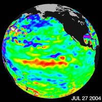
Recent sea-level height data from the U.S./France Jason altimetric satellite during a 10-day cycle ending July 27, 2004, show that weaker than normal trade winds in the western and central equatorial Pacific during June have triggered an eastward moving, warm Kelvin wave.
|
| ||||||||||
| The content herein, unless otherwise known to be public domain, are Copyright 1995-2016 - Space Media Network. All websites are published in Australia and are solely subject to Australian law and governed by Fair Use principals for news reporting and research purposes. AFP, UPI and IANS news wire stories are copyright Agence France-Presse, United Press International and Indo-Asia News Service. ESA news reports are copyright European Space Agency. All NASA sourced material is public domain. Additional copyrights may apply in whole or part to other bona fide parties. Advertising does not imply endorsement, agreement or approval of any opinions, statements or information provided by Space Media Network on any Web page published or hosted by Space Media Network. Privacy Statement All images and articles appearing on Space Media Network have been edited or digitally altered in some way. Any requests to remove copyright material will be acted upon in a timely and appropriate manner. Any attempt to extort money from Space Media Network will be ignored and reported to Australian Law Enforcement Agencies as a potential case of financial fraud involving the use of a telephonic carriage device or postal service. |