| . |  |
. |
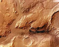
This image, taken by the High Resolution Stereo Camera (HRSC) on board ESA's Mars Express spacecraft, shows a region of Reull Vallis in the southern hemisphere of Mars. The image shows an area located at about latitude 42� South and longitude 102� East. The image was taken with a ground resolution of about 21 metres per pixel during Mars Express orbit 451 in May 2004. Reull Vallis is an outflow channel that extends 1500 kilometres across Promethei Terra in the direction of Hellas Basin. It is approximately 20 kilometres wide and has cut into the surrounding plain to a depth of 1800 metres. It is the major outflow channel in the region and exhibits a high degree of surface modification, suggesting a complex evolution. In this image, Reull Vallis extends from the east to the north-west, and is connected to a tributary in the south (Teviot Vallis). Distinct parallel structures are visible in the channels, possibly caused by glacial flow of loose debris mixed with ice. Small depressions, located on the flow features, are probably caused by the sublimation of ice. Numerous impact craters, visible on the flanks of the valley, have been filled with material from these flows. Distinct flow features can be recognised within impact craters, for example, the 15-kilometre wide crater in the west (bottom) of the image. There is a clear morphological distinction between the heavily eroded south-west and the plains of the north-east, which have experienced much less erosion. While most landforms throughout the image have a rounded, softened appearance, younger structures have a distinctly sharp and raised morphology. On the southern and western edges of the colour image, large impact craters are visible. Their diameters range from 15 to 35 kilometres. These craters have heavily eroded rims and are partly filled with material. Erosion has left distinct, branched gully systems at the edge of the large crater that is located on the southern edge of the image. Image resolution has been decreased for use on the internet. The image was processed using the HRSC nadir (vertical view) and three colour channels. Related Links Mars Express at ESA SpaceDaily Search SpaceDaily Subscribe To SpaceDaily Express 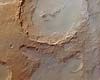 Paris, France (ESA) Nov 25, 2004
This image, taken by the High Resolution Stereo Camera (HRSC) on board ESA's Mars Express spacecraft, shows Crater Hale in the Argyre basin of the southern hemisphere of Mars. The image shows an area close to the northern rim of the Argyre basin, located at latitude 36� South and longitude 324� East. The image was taken with a ground resolution of about 40 metres per pixel during Mars Express orbit 533 in June 2004.
|
| ||||||||||
| The content herein, unless otherwise known to be public domain, are Copyright 1995-2016 - Space Media Network. All websites are published in Australia and are solely subject to Australian law and governed by Fair Use principals for news reporting and research purposes. AFP, UPI and IANS news wire stories are copyright Agence France-Presse, United Press International and Indo-Asia News Service. ESA news reports are copyright European Space Agency. All NASA sourced material is public domain. Additional copyrights may apply in whole or part to other bona fide parties. Advertising does not imply endorsement, agreement or approval of any opinions, statements or information provided by Space Media Network on any Web page published or hosted by Space Media Network. Privacy Statement All images and articles appearing on Space Media Network have been edited or digitally altered in some way. Any requests to remove copyright material will be acted upon in a timely and appropriate manner. Any attempt to extort money from Space Media Network will be ignored and reported to Australian Law Enforcement Agencies as a potential case of financial fraud involving the use of a telephonic carriage device or postal service. |