|
Free Newsletters - Space News - Defense Alert - Environment Report - Energy Monitor |
| . |  |
. |
|
|
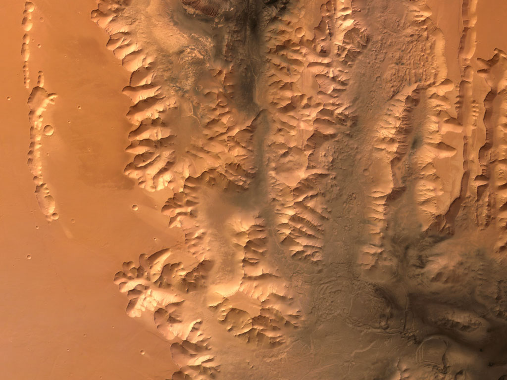
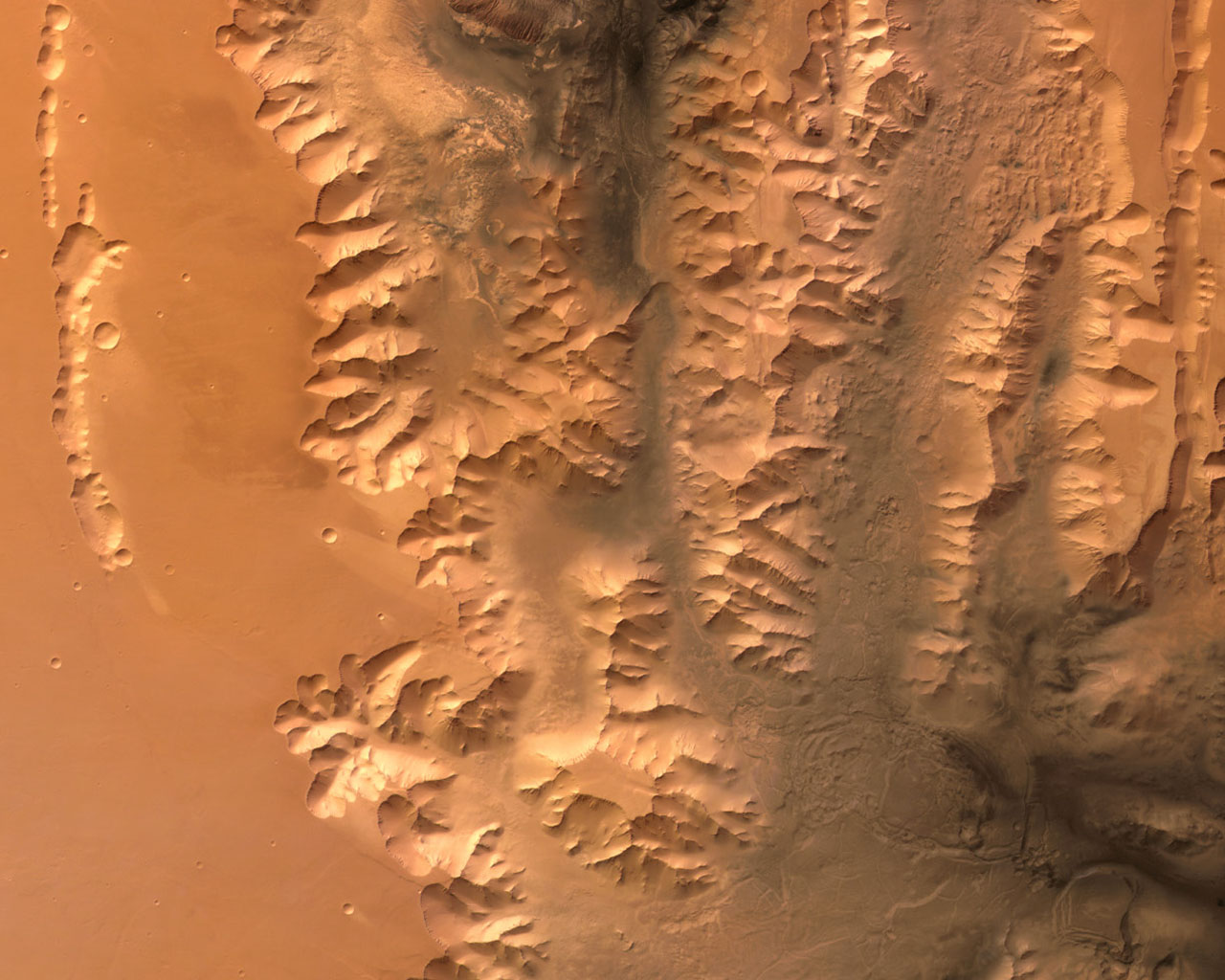
Tithonium Chasma, Valles Marineris, On Mars
This image, taken by the High Resolution Stereo Camera (HRSC) on board ESA's Mars Express spacecraft, shows the western end of the Valles Marineris Canyon system on Mars. The image was taken during orbit 442 with a ground resolution of approximately 52 metres per pixel. The displayed region is located at the beginning of the canyon system at about latitude 7� South and longitude 269� East. The image shows the western end of the canyons Tithonium Chasma and Ius Chasma, part of the Valles Marineris canyon system, which are up to 5.5 kilometres deep. The whole canyon system itself is the result of a variety of geological processes. Probably tectonic rifting, water and wind action, volcanism and glacial activity all have played major roles in its formation and evolution. The canyon floors are covered by a dark, layered material, the so-called 'Interior Layered Deposits'. These deposits are marked by a system of polygonal cracks through which the underlying, lighter-coloured rock can be seen. The Interior Layered Deposits are still a major topic of research. Parts of the deposits are most probably volcanic, while in other areas a sedimentary origin has been proposed. The morphology of the valley flanks has been modified by 'slumping' and rockfalls. Slumping is when a substantial part of a mountain, cliff or hill 'breaks away' and slides more or less intact to the bottom of the slope. Some of the major slumps here are more than thirty kilometres wide. The flanks are often covered to a large extent by their own 'talus', or rock debris that has fallen from the sides of a cliff or steep slope. The large, deeply eroded Crater Oudemans in the south of the area (bottom of the image) has a diameter of about 120 kilometres. Around the central mount of the crater, large plains composed of dark rock can be seen. These plains are covered by lighter sediments, deposited through the action of the wind. Several systems of tectonic faults can be seen in the imaged area. The most prominent is the system of Valles Marineris itself, running east-west. South of Crater Oudemans, smaller tectonic 'grabens' running from the south-west to the north-east can be seen. To the north of the large canyons, there are more fault systems. The Valles Marineris region is one of the most studied areas on Mars. The canyon system is one of the major keys to the tectonic and volcanic history of this planet. Research on the sedimentary rocks and the products of erosion can also provide major insights into its climatic evolution. Due to the stereo capability of the HRSC, the new image data gained can provide new insights into the geology of Mars. This will lead to a new, more precise reconstruction of Martian geological history. Image resolution has been decreased for use on the internet. The colour images were processed using the nadir (vertical view) and colour channels. Related Links Mars Express at ESA SpaceDaily Search SpaceDaily Subscribe To SpaceDaily Express  Paris (ESA) Oct 20, 2004
This image, taken by the High Resolution Stereo Camera (HRSC) on board ESA's Mars Express spacecraft, shows the eastern rim of the Martian impact crater Huygens. The image was taken during orbit 532 in June 2004 with a ground resolution of approximately 70 metres per pixel. The displayed region is centred around longitude 61� East and latitude 14� South.
|
| |||||||||||
| The content herein, unless otherwise known to be public domain, are Copyright 1995-2016 - Space Media Network. All websites are published in Australia and are solely subject to Australian law and governed by Fair Use principals for news reporting and research purposes. AFP, UPI and IANS news wire stories are copyright Agence France-Presse, United Press International and Indo-Asia News Service. ESA news reports are copyright European Space Agency. All NASA sourced material is public domain. Additional copyrights may apply in whole or part to other bona fide parties. Advertising does not imply endorsement, agreement or approval of any opinions, statements or information provided by Space Media Network on any Web page published or hosted by Space Media Network. Privacy Statement All images and articles appearing on Space Media Network have been edited or digitally altered in some way. Any requests to remove copyright material will be acted upon in a timely and appropriate manner. Any attempt to extort money from Space Media Network will be ignored and reported to Australian Law Enforcement Agencies as a potential case of financial fraud involving the use of a telephonic carriage device or postal service. |