| . |  |
. |
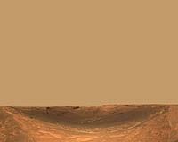
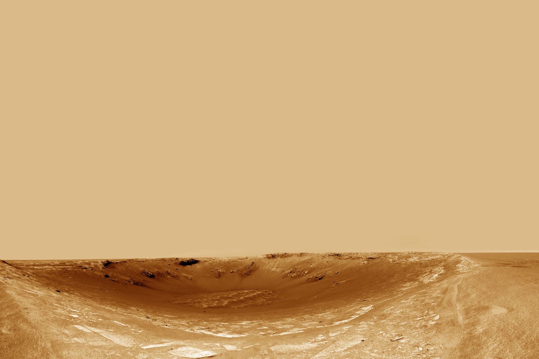
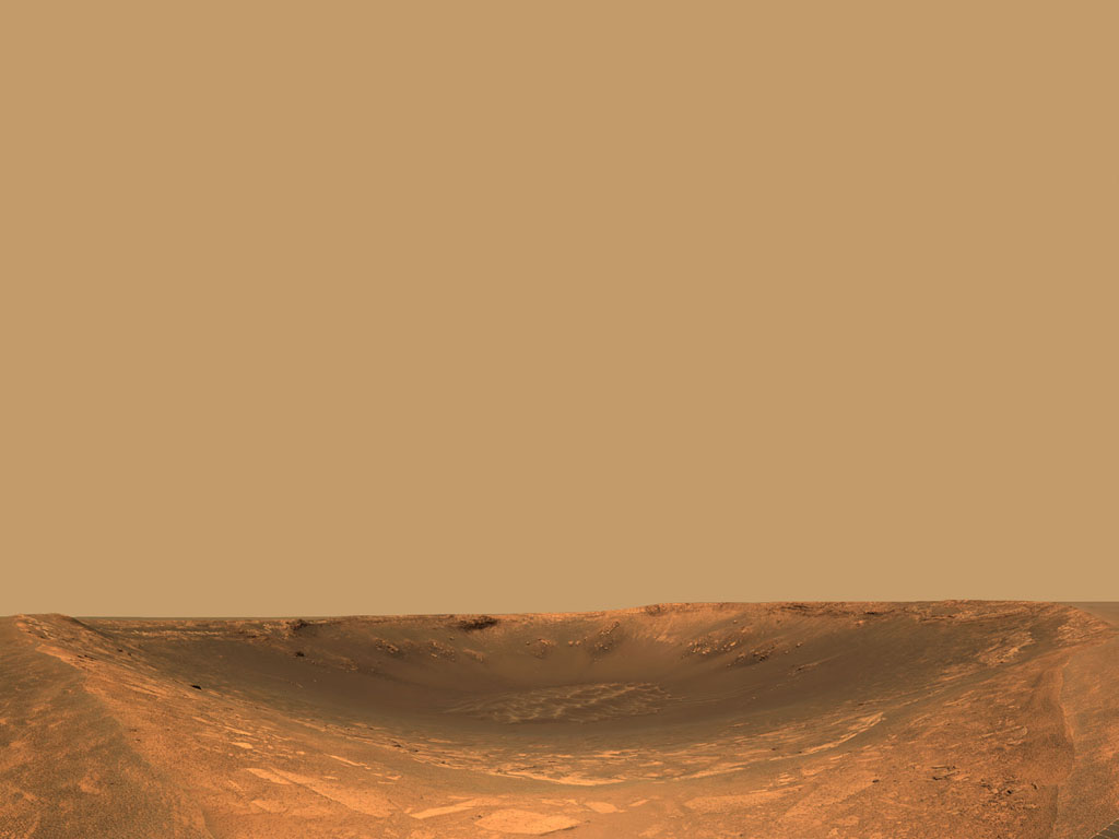
After a 50-meter (164-foot) drive on sol 94, which ended at 10:10 p.m. April 29 PDT, and the final approach of 17 meters (56 feet) on sol 95, which ended at 10:49 p.m. April 30 PDT, Opportunity arrived on the western rim of "Endurance Crater" and began surveying the spectacular new view. Opportunity sits about half a meter (1.6 feet) outside the edge of the crater with a positive pitch of 4.7 degrees, meaning the rover is slightly tilted with its head up. The western side of the crater rim slopes down in front of Opportunity with an angle of about 18 degrees for about 17 meters (56 feet). Sols 96 and 97, which ended at 11:29 p.m. May 1 PDT, and 12:08 a.m. May 3 PDT respectively, focused on remote sensing of Endurance Crater and the interesting features in and around it. All systems are healthy and Opportunity's batteries are near a full state of charge. The plan for sols 98 and 99, which end at 12:48 a.m. May 4 PDT and 1:28 a.m. May 5 PDT respectively, is to take advantage of Opportunity's current vantage point and take high-resolution miniature thermal emission spectrometer readings of the far crater wall.
Spirit explores the 'Big Hole' trench Sol 116 started with a repeat of the microscopic imaging of a target in the trench due to minor communication glitches on sol 115. Spirit then stowed the arm, backed away from Big Hole trench, and took panoramic camera images of the trench before it continued on its trek toward the Columbia Hills. The drive on sol 116, which ended at 11:08 a.m. May 1 PDT, established a new drive record of 90.8 meters (298 feet) for Spirit! On sol 117, which ended at 11:47 a.m. May 2, Spirit drove 37 meters (121 feet) to a small ridge, where the vehicle experienced a pitch up of 12.2 degrees. Engineers believe that the change in tilt caused the vehicle to recompute its "goodness map," which helps the rover autonomously drive over the martian terrain, and the rover declared that it was not safe to continue its drive. One good thing that came out of this is that the end-of-drive tilt positioned the solar arrays to maximize afternoon solar exposure, and the rover's battery state of charge is in good health.
Original Image Caption
The foreground highlights the now familiar ripples and dimples, common on the plains of Meridiani Planum. Some rock outcrop is seen emerging on the hill to the left, indicating that the rover is driving through the eroded remnants of the crater's ejecta blanket and is getting close to its rim. This light-colored outcrop is probably similar to the rocks seen at "Fram Crater" and "Anatolia," and studied in detail at "Eagle Crater." The foreground highlights the now familiar ripples and dimples, common on the plains of Meridiani Planum. Some rock outcrop is seen emerging on the hill to the left, indicating that the rover is driving through the eroded remnants of the crater's ejecta blanket and is getting close to its rim. This light-colored outcrop is probably similar to the rocks seen at "Fram Crater" and "Anatolia," and studied in detail at "Eagle Crater." Several rocks appear to be dotted with the same "blueberries," or iron-rich spherules. Detailed comparisons between soils exposed at the surface and those found at depth reveal that surface soils have higher levels of hematite while subsurface soils show fine particles derived from basalt. The rover may return to Fram for further analysis of its rocks and soils if time permits. The Eagle Crater rocks are believed to have been deposited in an open body of water. The science team is intrigued by the darker rock on the far side of the crater wall. Just right of the center, on the far crater wall, rocks appear to form thick, massive layers, suggesting they may have been formed by a different geologic processes than the lighter rocks in the foreground. The greater thickness of layered rocks at Endurance Crater will provide the team with a longer record of geologic processes operating at Meridiani Planum. Related Links Mars Rovers at JPL Mars Rovers at Cornell SpaceDaily Search SpaceDaily Subscribe To SpaceDaily Express  Pasadena (JPL) Apr 29, 2004
Both of NASA's Mars Exploration Rovers have completed their originally planned mission and are tackling extra-credit assignments.
|
| |||||||||||
| The content herein, unless otherwise known to be public domain, are Copyright 1995-2016 - Space Media Network. All websites are published in Australia and are solely subject to Australian law and governed by Fair Use principals for news reporting and research purposes. AFP, UPI and IANS news wire stories are copyright Agence France-Presse, United Press International and Indo-Asia News Service. ESA news reports are copyright European Space Agency. All NASA sourced material is public domain. Additional copyrights may apply in whole or part to other bona fide parties. Advertising does not imply endorsement, agreement or approval of any opinions, statements or information provided by Space Media Network on any Web page published or hosted by Space Media Network. Privacy Statement All images and articles appearing on Space Media Network have been edited or digitally altered in some way. Any requests to remove copyright material will be acted upon in a timely and appropriate manner. Any attempt to extort money from Space Media Network will be ignored and reported to Australian Law Enforcement Agencies as a potential case of financial fraud involving the use of a telephonic carriage device or postal service. |