|
Free Newsletters - Space News - Defense Alert - Environment Report - Energy Monitor |
| . |  |
. |
|
|
NOAA Offers New Experimental Ionospheric Products
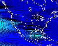
NOAA's Space Environment Center and National Geodetic Survey recently released (November 1) new experimental ionosphere products to help emergency managers and other users quickly assess the effects of solar storm on Global Positioning System applications. NOAA, the National Oceanic and Atmospheric Administration, is an agency of the U.S. Department of Commerce. The SEC has created a near real-time ionospheric specification map of total electron content over the continental United States that updates every 15 minutes. The USTEC map, available online at http://www.sec.noaa.gov/ustec , will aid users affected by ionospheric conditions - GPS applications, surveyors, emergency managers, and others - to quickly assess the current situation that may impact their systems. The ionosphere is the area of the Earth's atmosphere beginning at an altitude of about 30 miles and extending upwards to 10,000 miles. Free electrons slow and disrupt the GPS signal as it passes through the ionosphere. "This map is the initial offering in an ongoing effort to provide improved products and services to a significant part of the SEC users community," said Ernest Hildner, director of NOAA's Space Environment Center in Boulder, Colo. Past maps and related source data will be available from the National Geophysical Data Center Web site This product results from contributions of the National Geodetic Survey, National Geophysical Data Center, Forecast Systems Lab, and the Cooperative Institute for Research in the Environmental Sciences at the University of Colorado. The NGS also announce two new ionosphere models over the continental United States. These two highly accurate models (MAGIC and ICON-1) use the full set of Continuously Operating Reference Stations and provide ionospheric information between CORS stations and GPS satellites with a three-day delay. Thanks to these models, users will be able to more precisely compute positions from GPS. Both MAGIC and ICON-1 are prototype models, part of ongoing research projects, but are being made available free to the general public for testing and evaluation purposes. They may be found at http://www.ngs.noaa.gov/Ionosphere. Related Links NOAA SpaceDaily Search SpaceDaily Subscribe To SpaceDaily Express  Sunnyvale CA (SPX) Oct 26, 2004
Trimble and Nextel Communications announced Monday that the companies will launch Trimble Outdoors service in time for the holiday season. The service is an online solution that enables customers to plan an outdoor adventure, share their trip with friends and family, and research trips taken by others, including reviewing routes and points of interest on street aerial, or topographic maps covering the continental U.S. and parts of Alaska and Hawaii.
|
| |||||||||||
| The content herein, unless otherwise known to be public domain, are Copyright 1995-2016 - Space Media Network. All websites are published in Australia and are solely subject to Australian law and governed by Fair Use principals for news reporting and research purposes. AFP, UPI and IANS news wire stories are copyright Agence France-Presse, United Press International and Indo-Asia News Service. ESA news reports are copyright European Space Agency. All NASA sourced material is public domain. Additional copyrights may apply in whole or part to other bona fide parties. Advertising does not imply endorsement, agreement or approval of any opinions, statements or information provided by Space Media Network on any Web page published or hosted by Space Media Network. Privacy Statement All images and articles appearing on Space Media Network have been edited or digitally altered in some way. Any requests to remove copyright material will be acted upon in a timely and appropriate manner. Any attempt to extort money from Space Media Network will be ignored and reported to Australian Law Enforcement Agencies as a potential case of financial fraud involving the use of a telephonic carriage device or postal service. |