| . |  |
. |
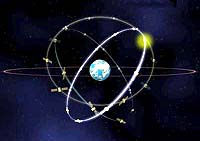
Engineers at Purdue University and NASA have developed a new technique for monitoring the environment by using routine signals that already are being beamed to Earth by global positioning systems. Conventional techniques for gathering information about global climate change and other environmental data require systems that have their own transmitters and receivers on satellites or aircraft. The equipment, though, is relatively heavy and consumes large amounts of power. The new technique could be used for alternative or complementary systems on aircraft and satellites. The method does not require a transmitter because it uses the signals already being transmitted by GPS satellites. That makes it possible to design a system that only requires a receiver, other hardware and special software that is one-tenth the weight and uses about one-tenth the energy of conventional systems, said James Garrison, an assistant professor of aeronautics and astronautics at Purdue University. Garrison will present a paper on this technique July 13 at a special session during the International Geoscience and Remote Sensing Symposium, in Sydney, Australia. The conference is sponsored by the Institute of Electrical and Electronics Engineers, NASA and the National Oceanic and Atmospheric Administration. Satellite GPS systems are constantly broadcasting microwave signals to Earth. The signals are used for everything from military maneuvers to directions for lost motorists, and ship navigation to measurements for agriculture. The systems work by timing how long it takes for signals to get from the satellite to a receiver on the ground. Because the speed of the signal is known, the difference between when the signal is sent and when it is received reveals the distance of the receiver. Signals from several satellites are needed to provide a three-dimensional fix -- a precise location of the receiver on the Earth's surface. Those same microwave signals, however, also bounce off of the Earth's surface and oceans and can be picked up by receivers on aircraft or satellites, recorded and used to study conditions on the planet. "Twenty-four hours a day, all around the world, they are broadcasting this signal," Garrison said. "Our transmitter is provided by the GPS satellite. So we get the transmitter for free 24 hours a day." The new system, invented by Garrison and NASA engineer Stephen Katzberg, would use GPS signals to collect environmental data for studies aimed at understanding global climate change. "The small size and low cost of the instrumentation would make operational deployment on balloons or small aircraft very affordable," Garrison said. Because water is an especially good reflector of GPS signals, the new technique is promising for studying how ocean-related conditions affect global circulation and world climate. For example, scientists monitor wind patterns near the surfaces of the oceans to track global circulation, which influences climate. As each GPS signal bounces off of the water, it reflects from numerous facets on the rough, undulating surface. The signal is then picked up by a receiver, located on an aircraft or a satellite, and then software interprets the data, providing detailed measurements of the changing ocean surface. "The roughness of the surface is directly related to near-surface meteorological conditions," said Garrison, a former NASA engineer who began the research while working for the space agency. Several research papers to be discussed during the upcoming conference in Sydney will specifically address the feasibility of a satellite instrument to measure ocean surface meteorological data using reflected GPS signals. Garrison and Katzberg originally were trying to invent a system that would use GPS signals to take images of objects on the Earth's surface, an application that would have various potential uses, including military operations. They were awarded a patent for that application in 1999 and still may pursue the research, depending on the availability of funding, Garrison said. Because the system is lighter and uses less energy than conventional systems, it would be ideal for installation on small remotely piloted drones called unmanned aerial vehicles. It also would have benefits for satellite systems, he said. "In the design of satellites, power is a big concern because systems that use a lot of power require larger solar arrays," Garrison said. "The larger solar arrays require a larger satellite structure, and large solar arrays also put more demand on attitude control." The new technique also has other advantages. It works well when there is heavy moisture in the atmosphere during storms, unlike some of the conventional remote-sensing systems. It also is easier to use because it does not require complicated calibrations now required for conventional systems. Tests using aircraft equipped with the system have yielded "significant data," which will be used to improve the technology so that it might be incorporated into satellites, Garrison said. Engineers are working on a new version that will not require conventional GPS navigation hardware. Instead, software will perform all of the functions now needed for the GPS hardware, making the system more versatile and increasing its potential applications. Garrison and Katzberg recently won an Exceptional Space Act Award from NASA for the patented system. The awards are granted for scientific and technical contributions that have been "determined to have significant value in the conduct of aeronautical and space activities," according to a NASA description. Garrison said he intends to use his findings as a teaching tool for graduate students learning about GPS signals. Related Links Schools of Engineering at Purdue University SpaceDaily Search SpaceDaily Subscribe To SpaceDaily Express  San Diego - June 21, 2001
E-tenna has launched its new AccuWave product line. AccuWave is designed to improve the performance and reduce the size and cost of global positioning system (GPS) antennas for high-precision applications.
|
| ||||||||||
| The content herein, unless otherwise known to be public domain, are Copyright 1995-2016 - Space Media Network. All websites are published in Australia and are solely subject to Australian law and governed by Fair Use principals for news reporting and research purposes. AFP, UPI and IANS news wire stories are copyright Agence France-Presse, United Press International and Indo-Asia News Service. ESA news reports are copyright European Space Agency. All NASA sourced material is public domain. Additional copyrights may apply in whole or part to other bona fide parties. Advertising does not imply endorsement, agreement or approval of any opinions, statements or information provided by Space Media Network on any Web page published or hosted by Space Media Network. Privacy Statement All images and articles appearing on Space Media Network have been edited or digitally altered in some way. Any requests to remove copyright material will be acted upon in a timely and appropriate manner. Any attempt to extort money from Space Media Network will be ignored and reported to Australian Law Enforcement Agencies as a potential case of financial fraud involving the use of a telephonic carriage device or postal service. |