| . |  |
. |
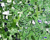
Montana's high tech farmers are looking at their fields with new "eye in the sky" technology this summer, thanks to NASA and the MSU TechLink Center. In its first comprehensive remote sensing evaluation project, the Precision Agriculture Research Association (PARA) is comparing different types of imagery as a real-time decision aid to help determine when and where to apply fertilizers, pesticides, and nutrients to their crops. The aim of the project is to produce a business plan and commercialize the technology that is most cost-effective for wheat and barley producers in the high plains. "In today's Montana agriculture, one can't hire someone to be in the field on an entire farm on a weekly basis," said Chuck Merja, PARA board member. "This technology helps get eyes on each field each week during the growing season." Remote sensing is an efficient way to cover all of a farm's acres and help producers budget physical visits and inputs for specific areas of need. PARA and technical advisors from Montana State University are evaluating several different types of remote sensing imagery for use with their own computer software. The project is being cost-shared roughly equally by the members of PARA, by NASA's Upper Midwest Aerospace Consortium (UMAC), and by TechLink. This summer alone, UMAC reported that the NASA remote sensing project had surveyed some 800 square miles of farmland in Wyoming, South Dakota, and Montana, including sites near Chester, Valier, Conrad, Power, Great Falls, Sun River, Big Timber, and Billings. The images were obtained by flying digital imaging systems over specific growers' fields. Wheat, barley and forage producers in the Golden Triangle area who own the land that was surveyed this season were able to view most of their images by the evening of the flight, thanks to high speed internet delivery. "Getting imagery into growers' hands within a few hours of acquisition was an important part of the project, because they could then use the images to make real decisions," said Gary Arnst, the PARA member who spearheaded the higher resolution, fast turnaround imagery. PARA members are now comparing the remote sensing data obtained from the various systems and will be developing a business plan to make the technology available to a larger audience starting next year. Montana agricultural producers face many challenges including pressures to lower costs, increase production, and maintain good stewardship practices on the land. Consequently, as many producers begin to farm more land and produce larger crops, it becomes increasingly difficult to monitor their fields and respond to multiple crop needs in a timely fashion. PARA is hoping to demonstrate that the use of remote sensing technology will provide fast and convenient monitoring of resources so producers can exercise best-practices for optimal crop management and productivity. NASA has played a key role in growing the remote sensing industry in the United States. PARA members had access to satellite imagery last year through a UMAC project. Observations from that experience led members on a quest for better resolution and more frequent images. While most of the images collected this season were false color composites, the images provided with TechLink funding are 4 band, high resolution, georeferenced images, so they can be viewed in false color or true color and so they drop right into farmers' GIS software. Vegetative indices, which are very helpful for understanding vegetative health can be calculated and viewed using any of the systems flown this summer. "These images were very useful in making real time decisions this summer, but they will also be useful for years to come when they are compared to future images, yield maps, water holding capacity maps, weed maps and other information that PARA members collect from their fields," said Carl Mattson, president of PARA. "We are very thankful for the foresight of university faculty within UMAC and TechLink for helping us collect and make sense out of the images we acquired the last two seasons. This has been a great collaborative effort and will become a good management tool for a lot of crop and livestock producers." TechLink is located at Montana State University in Bozeman and funded by NASA and the Department of Defense to link companies in Montana and the surrounding region with federal laboratories for joint research and technology transfer. Its overriding purpose is to contribute to the success of both technology-based companies and key resource-based industries in the state and region. Related Links MSU TechLink SpaceDaily Search SpaceDaily Subscribe To SpaceDaily Express  Fayetteville - July 23, 2001
In Arkansas, farmers will check their fields for changes in moisture levels and forestry workers can examine forests for pest outbreaks with the click of a few buttons, thanks to new technology created by University of Arkansas researchers and housed on campus.
|
| ||||||||||
| The content herein, unless otherwise known to be public domain, are Copyright 1995-2016 - Space Media Network. All websites are published in Australia and are solely subject to Australian law and governed by Fair Use principals for news reporting and research purposes. AFP, UPI and IANS news wire stories are copyright Agence France-Presse, United Press International and Indo-Asia News Service. ESA news reports are copyright European Space Agency. All NASA sourced material is public domain. Additional copyrights may apply in whole or part to other bona fide parties. Advertising does not imply endorsement, agreement or approval of any opinions, statements or information provided by Space Media Network on any Web page published or hosted by Space Media Network. Privacy Statement All images and articles appearing on Space Media Network have been edited or digitally altered in some way. Any requests to remove copyright material will be acted upon in a timely and appropriate manner. Any attempt to extort money from Space Media Network will be ignored and reported to Australian Law Enforcement Agencies as a potential case of financial fraud involving the use of a telephonic carriage device or postal service. |