| . |  |
. |
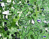
In Arkansas, farmers will check their fields for changes in moisture levels and forestry workers can examine forests for pest outbreaks with the click of a few buttons, thanks to new technology created by University of Arkansas researchers and housed on campus. RAPID-AmericaView, a first-of-its-kind cooperative project between U of A researchers, the U.S. Geological Survey (USGS) and the Arkansas State Land Information Board, provides "same day service" conversion of Earth orbiting satellite data into easy to use, publicly available information that can be downloaded from the World Wide Web. "The technology will demonstrate how remotely sensed data can truly solve near real-time needs that exist within the state of Arkansas," said Chris Doescher of the USGS EROS Data Center in South Dakota, co-leader of the AmericaView project. The University of Arkansas Center for Advanced Spatial Technologies (CAST) has created a program to enhance the work of AmericaView, a USGS program designed to increase public access to geospatial data. Called RAPID (Real-time Acquisition and Processing of Imagery Data), the CAST program quickly translates raw data, taken from the Landsat 7 satellite and processed by the USGS, into usable information. "In this project we will be able to have some processed imagery products accessible to the public in our Oracle-based state warehouse (GeoStor) within 10 minutes of receipt from the USGS," said Fred Limp, director of CAST. More detailed information could take up to six hours, but the turnaround time for public access still beats the current methods, which can take anywhere from two to six weeks. The USGS data comes to users in its raw form, and it takes sophisticated knowledge of remote sensing to turn the data into helpful information, like road locations or elevations. And even programs that offer processed information often require that you download everything -- gigabytes of information that might choke a personal computer. "Through this project, a person will be able to type in his or her address, draw a box around the house, and get the data specifically for the designated area," Limp said. Current information can be vital to farmers, who need to make decisions vital to their crops' survival. The State Land Information Board, created by legislative act 914 of 1997, strives to bring geospatial information to Arkansas' citizens in order to facilitate improved decision making, effective asset management, and reduced costs. The SLIB seeks to facilitate cooperative agreements and partnerships among state entities in order to purchase satellite data that will best meet the needs of its users. The board worked with CAST to develop GeoStor, a warehouse containing geographic data on Arkansas that is currently accessible by Internet. Through Geostor, anyone with an Internet browser can download more than 500 layers of information about the state. Typical layers that one might use in GIS applications include roads, cities, interstates, creeks, streams, state parks, rest areas, churches, railway stations, grain elevators -- anything that might be found on a map and more, according to Learon Dalby, GIS program manager with the State Land Information Coordinator's Office. The RAPID project will add a new dimension to GeoStor, allowing public access to the data as rapidly as possible. Such data could be extremely useful in the wake of natural disasters, such as flooding, fires, tornadoes or ice storms, depending upon the location of the satellite, which sequentially images different locations and may not be sending data during or immediately after a disastrous event. In the long term, it could also help farmers protect their crops from drought and disease more efficiently, said Suzanne Wiley, GIS applications specialist for the U of A Cooperative Extension Service and chairman of the State Land Information Board. "Farmers will have a new management tool on their computer desktops. Access to timely imagery will aid in the surveillance of crop conditions throughout the growing season," she said. The Landsat 7 satellite collects detailed images of earth based on its location and on a number of "spectral bands," the electromagnetic radiation in different parts of the electromagnetic spectrum. Each feature on earth -- corn, wheat, water, concrete -- has a different "signature" based on its electromagnetic radiation. Researchers use sophisticated computer programs to determine these combinations and create a detailed map of the surface in question. Corporate partners have provided key technology pieces for CAST. These include image processing software from PCI Geomatics, computer systems from Sun Microsystems and data base software from Oracle Corporation. Each of these companies has designated CAST as a Center of Excellence and is working with CAST on these next-generation projects. Related Links Center for Advanced Spatial Technologies AmericaView SpaceDaily Search SpaceDaily Subscribe To SpaceDaily Express  Pasadena - May 8, 2001
Some of the people closest to the land will be the first to benefit from a new global positioning technology developed to make NASA satellites more efficient and cost-effective.
|
| ||||||||||
| The content herein, unless otherwise known to be public domain, are Copyright 1995-2016 - Space Media Network. All websites are published in Australia and are solely subject to Australian law and governed by Fair Use principals for news reporting and research purposes. AFP, UPI and IANS news wire stories are copyright Agence France-Presse, United Press International and Indo-Asia News Service. ESA news reports are copyright European Space Agency. All NASA sourced material is public domain. Additional copyrights may apply in whole or part to other bona fide parties. Advertising does not imply endorsement, agreement or approval of any opinions, statements or information provided by Space Media Network on any Web page published or hosted by Space Media Network. Privacy Statement All images and articles appearing on Space Media Network have been edited or digitally altered in some way. Any requests to remove copyright material will be acted upon in a timely and appropriate manner. Any attempt to extort money from Space Media Network will be ignored and reported to Australian Law Enforcement Agencies as a potential case of financial fraud involving the use of a telephonic carriage device or postal service. |