| . |  |
. |
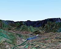
Chairman, ISRO, Shri G Madhavan Nair and a team of senior scientists presented to the Prime Minister the first imageries from the recently launched CARTOSAT-1 satellite, today (May 13, 2005) at the Parliament House, New Delhi. Chairman ISRO made a presentation to the PM on the PSLV C6/ CARTOSAT-1/ HAMSAT mission operations, performance of launch vehicle PSLV, Cartosat-1 and Hamsat. PM was shown the first pictures received from the satellite over Punjab and Gujarat, with 2.5 metre resolution stereoscopic camera and the digital terrain model processed from the satellite pictures over Gujarat. Prime Minister while evincing keen interest in the details depicted in the imagery, congratulated ISRO scientists for their outstanding achievement. Minister of State Shri Prithviraj Chavan, National Security Advisor Shri MK Narayanan and Principal Secretary to Prime Minister, Shri TKA Nair were also present during the meeting and appreciated ISRO's efforts. The ISRO team had Dr PS Goel, Director, ISRO Satellite Center, Dr KN Shankara, Director, Space Applications Centre, Shri K Narayana, Director, Satish Dhawan Space Centre, Dr RR Navalgund, Director, National Remote Sensing Agency, Shri N Narayana Murthy, Mission Director of PSLV C6/Cartosat-1/Hamsat mission along with their senior colleagues. Related Links SpaceDaily Search SpaceDaily Subscribe To SpaceDaily Express 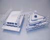 Houston TX (SPX) May 13, 2005
Scientists are preparing to step up research in the Polar Regions, and University of Houston architecture students and staff are designing the facility at the Greenland Summit that sits atop more than 10,000 feet of ice.
|
| ||||||||||
| The content herein, unless otherwise known to be public domain, are Copyright 1995-2016 - Space Media Network. All websites are published in Australia and are solely subject to Australian law and governed by Fair Use principals for news reporting and research purposes. AFP, UPI and IANS news wire stories are copyright Agence France-Presse, United Press International and Indo-Asia News Service. ESA news reports are copyright European Space Agency. All NASA sourced material is public domain. Additional copyrights may apply in whole or part to other bona fide parties. Advertising does not imply endorsement, agreement or approval of any opinions, statements or information provided by Space Media Network on any Web page published or hosted by Space Media Network. Privacy Statement All images and articles appearing on Space Media Network have been edited or digitally altered in some way. Any requests to remove copyright material will be acted upon in a timely and appropriate manner. Any attempt to extort money from Space Media Network will be ignored and reported to Australian Law Enforcement Agencies as a potential case of financial fraud involving the use of a telephonic carriage device or postal service. |