| . |  |
. |
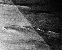
Three of the world's largest and fastest yachts are in the midst of a non-stop trans-global race, hurtling in excess of 25 knots - 46 kilometres per hour - through the Southern Ocean encircling Antarctica. Iceberg collision is a real risk, but ice-sensitive radar satellites are monitoring the area to provide advance warning to crews. "It has been a huge tactical � and psychological - advantage to planning our track through the Southern Ocean," says navigator Will Oxley aboard trimaran Doha2006, current leader in the Oryx Quest race. "We have been very cautious with the knowledge of just how much ice is around and just how far north it is." One million US dollars (755 000 euros) awaits the winner of the 40 000-kilometre Oryx Quest 2005. Three of the world's seven multi-hull super-yachts are taking part (a fourth has just been forced out of the race due to structural problems), all of them exceeding 30 metres long and capable of maximum speeds greater than 40 knots (74 kph). The race began on 5 February 2005 in Doha, capital of the Gulf State of Qatar, and is expected to conclude around fifty days later at the same location, the yachts having to pass through the Southern Ocean and round the Cape of Good Hope and Cape Horn before returning to the Gulf of Arabia. "Icebergs are one of those things you really never want to see," said meteorologist Chris Bedford of Sailing Weather Services. "So if the racers never spot one that will count as success! As an Oryx Quest race meteorologist I help provide weather forecasts to the crews and work on route planning. Safety is a very high priority, and with this new satellite data analysis we can tell crews where they should steer to stay clear of ice fields." The Southern Ocean is home to the world's stormiest waters, along with many icebergs � the largest have been known to extend several hundreds of metres beneath the surface of the sea. There are also many associated broken-off ice pieces. Large or small, running into them at high speed would have the same effect as smashing a car into concrete. Large icebergs can be detected by yachts' onboard radar but smaller, largely submerged 'growlers' or 'bergy bits' cannot. The safest option is to give all icebergs a wide berth. The crews have the knowledge to do this thanks to an iceberg-detection service employing data from the ESA's Envisat and the Canadian Space Agency's Radarsat satellites. The service is provided by Canadian company C-CORE, operating as part of a consortium called The Northern View. This initiative supplies a portfolio of information products and operational services based on Earth Observation data, including an operational iceberg-tracking service for shipping and offshore operations in Canadian waters. "This is the first time we have extended our activities into the waters of the southern hemisphere," said Desmond Power of C-CORE. "We acquire images ahead of the race route, using the Synthetic Aperture Radar (SAR) instruments on Envisat and Radarsat. "Icebergs typically have a stronger radar signal return than the open ocean. After initial processing to get rid of 'cluttering' effects from ocean waves we analyse the shape, number of pixels and intensity of signal returns to differentiate between icebergs and ships, which can appear similar. Sometimes we are uncertain so rather than hold any potentially useful information back we label the returns according to a confidence classification ranging from strong to weak certainty." C-CORE has been using Envisat's Advanced Synthetic Aperture Radar (ASAR) in Wide Swath Mode (WSM) giving 400 km swath to a resolution of 150 metres, together with Radarsat ScanSAR Narrow Mode with a 300 km swath to a resolution of 50 metres. Envisat results have been relayed via ESA's Artemis communications satellite to the satellite's rolling data archive in the European Space Research Institute (ESRIN) in Italy, so they are available to C-CORE for analysis within two hours of acquisition. "This race is the first time we have had full access to this data, and it is proving very useful" added Bedford. "We typically get at least one new satellite image a day. Previously we were relying more on climatology or anecdotal information to get an idea where icebergs were likely to be. Few ships normally sail in these waters so there is little first-hand knowledge to be had." The iceberg-detection service looks likely to be extended to further competitive yacht races in future, starting with the round-the-world Volvo Ocean Race 2005-2006, due in November. The Northern View is part of Global Monitoring for Environment and Security (GMES), a joint initiative by ESA and the European Commission (EC) to establish an independent global monitoring capacity in support of European policy goals. The Northern View is one of 12 initial projects run by ESA under the GMES umbrella known as the GMES Services Element (GSE). Related Links SpaceDaily Search SpaceDaily Subscribe To SpaceDaily Express  Swampscott MA (SPX) Mar 07, 2005
GeoVantage has announced the delivery of a 540,000 acre imagery project to Olympic Resource Management. GeoVantage delivered one meter pixel resolution, multi-spectral orthophotography in both full color and near infrared. The 2004 collection and delivery represents GeoVantage's largest project to date in the Pacific Northwest.
|
| ||||||||||
| The content herein, unless otherwise known to be public domain, are Copyright 1995-2016 - Space Media Network. All websites are published in Australia and are solely subject to Australian law and governed by Fair Use principals for news reporting and research purposes. AFP, UPI and IANS news wire stories are copyright Agence France-Presse, United Press International and Indo-Asia News Service. ESA news reports are copyright European Space Agency. All NASA sourced material is public domain. Additional copyrights may apply in whole or part to other bona fide parties. Advertising does not imply endorsement, agreement or approval of any opinions, statements or information provided by Space Media Network on any Web page published or hosted by Space Media Network. Privacy Statement All images and articles appearing on Space Media Network have been edited or digitally altered in some way. Any requests to remove copyright material will be acted upon in a timely and appropriate manner. Any attempt to extort money from Space Media Network will be ignored and reported to Australian Law Enforcement Agencies as a potential case of financial fraud involving the use of a telephonic carriage device or postal service. |